Map of Juan de la Cosa facts for kids
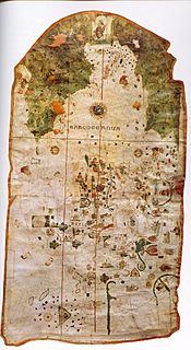
The map of Juan de la Cosa is a very old world map. It was probably made in the year 1500. This map is special because it shows the New World (the Americas) for the first time. It also has the first known drawings of the equator and the Tropic of Cancer on a sea map.
This important map is believed to have been created by Juan de la Cosa. He was a navigator and mapmaker from Castile, a kingdom in what is now Spain.
Contents
What Makes This Map Special?
How the Map Looks
Juan de la Cosa's map is a handmade sea chart of the world. It was drawn on two pieces of parchment (animal skin used for writing). These pieces were then sewn together and put onto a canvas backing. The map is quite large, measuring about 96 centimeters (38 inches) high and 183 centimeters (72 inches) wide.
On the left side of the map, there is a message written in Spanish. It says, "Juan de la Cosa made this (map) in the port of Santa Maria in the year 1500." The map's overall style is similar to other sea charts made around that time. Many maps were made in Majorca, which was a very important place for mapmaking.
Old World and New World
This map is actually made from two different charts put together. One part shows the Old World (Europe, Africa, and Asia) and the Atlantic Ocean. The other part shows the New World (the Americas).
The New World part of the map is colored green. The Old World part is left uncolored. The Old World map includes discoveries made up to 1488. But the New World map is very up-to-date for the year 1500. The two maps are also drawn at different sizes. The New World part is larger than the Old World part.
This map is the first sea chart known to show the equator and the Tropic of Cancer. These are important lines that help people understand Earth's geography.
Mapping the Old World
The way Europe, Africa, and Asia are shown on the map is not very surprising. The shapes of Europe and the Mediterranean Sea were likely copied from portolan charts. These were common sea maps available at the time.
The western and southern coasts of Africa show good knowledge from Portuguese explorations. However, the eastern coast of Africa is not drawn very well. Asia and the Indian Ocean parts of the map follow the ideas of Ptolemy. He was an ancient Greek geographer.
Mapping the New World
While the Old World part of the map is quite standard, including the New World was a huge step forward in mapmaking. Cosa's map is the oldest map that still exists showing the Americas.
It is also the only known map made by someone who was actually there on the first trips of Christopher Columbus. Juan de la Cosa also went on a voyage in 1496 with Alonso de Ojeda along the coast of South America.
The map also includes discoveries made by other explorers. These include John Cabot, Vicente Pinzon, and Pedro Álvares Cabral. The map even has flags of different countries drawn on it. These flags show which country discovered each region.
North and South America on the Map
North America is shown as a large landmass reaching far into the North Atlantic Ocean. South America looks like a continent. However, both are drawn in a way that could mean they are just an extension of Asia. They are not clearly shown as entirely new continents.
The Caribbean islands, such as Cuba, Hispaniola, and Puerto Rico, are drawn fairly accurately. Cuba, in particular, is correctly shown as an island. This is interesting because Columbus believed Cuba was a peninsula of Asia. The first time Cuba was fully sailed around was not until 1508.
The Mystery of Central America
The area of Central America on the map is covered with a picture of Saint Christopher. He is shown carrying the baby Christ across the water. This picture might be a hint about Christopher Columbus. It could mean he was bringing Christianity across the Atlantic Ocean.
It also suggests that there might be a passage to the Indian Ocean in that area. Columbus strongly believed such a passage existed. The promise of an easy way to get valuable spices was probably what convinced the Spanish rulers to pay for Columbus's fourth (and last) voyage.
History of the Map
Columbus might have given this map to the Spanish rulers in 1503. Later, it may have been given to Juan Rodríguez de Fonseca, who was an advisor to the king. After that, no one knew what happened to the map for a long time.
In the early 1800s, a man named Baron Charles-Athanase Walckenaer bought it from a junk shop in Paris. In 1832, a German scientist named Alexander von Humboldt was the first to realize how important this old map was. The Spanish government bought the map in 1853. Today, it is part of the collection at the Naval Museum in Madrid, Spain.
See also
- Ancient world maps
- World map
- Cantino planisphere
 In Spanish: Mapa de Juan de la Cosa para niños
 | Valerie Thomas |
 | Frederick McKinley Jones |
 | George Edward Alcorn Jr. |
 | Thomas Mensah |


