
Cameroon line facts for kids
The Cameroon line is a long chain of volcanoes, about 1,600 kilometers (1,000 miles) long. It includes islands in the Gulf of Guinea and mountains on the African mainland. This volcanic chain stretches from Mount Cameroon on the coast all the way to Lake Chad in the northeast. It also forms a natural border between eastern Nigeria and the West Region of Cameroon.
The islands along the Cameroon line are located near the equator and have warm, tropical weather. They are home to many special plants and birds found nowhere else. The mountain areas on the mainland are much cooler than the flat lands around them. These areas also have unique and important natural environments.
What makes the Cameroon volcanic line special is that it goes through both the ocean and the land. Scientists have different ideas about how this unusual chain of volcanoes formed.
Contents
Where is the Cameroon Line?
.jpg)

The Cameroon line includes several islands and underwater mountains in the Gulf of Guinea. These islands stretch from the southwest to the northeast. They are Annobón, São Tomé, Príncipe, and Bioko. There are also two large underwater mountains (called seamounts) between São Tomé and Príncipe, and between Príncipe and Bioko.
On the mainland, the line begins with Mount Cameroon. It then goes northeast into a mountain range called the Western High Plateau. This area is home to the Cameroonian Highlands forests. Further inland, you'll find other volcanic mountains like Manengouba, Bamboutu, and the Oku Massif. There are even more volcanic mountains to the east in the Ngaoundere Plateau, which might have formed in a similar way.
Islands of the Cameroon Line
Annobón Island
Annobón, also known as Pagalu, is the southernmost island in the chain. It covers about 17.5 square kilometers (6.8 square miles). This island is an extinct volcano that rises from deep ocean waters to 598 meters (1,962 feet) above sea level. Annobón belongs to Equatorial Guinea.
The island's average temperature is about 26.1°C (79°F) all year round. Most of the rain falls from November to May. Annobón has green valleys and steep mountains covered with thick forests. A small number of people live in one community there. They mostly fish for a living, but also do some farming.
São Tomé Island


São Tomé island is about 854 square kilometers (330 square miles) and lies almost exactly on the equator. The entire island is a huge shield volcano. It rises from the bottom of the Atlantic Ocean, which is over 3,000 meters (9,800 feet) deep, and reaches 2,024 meters (6,640 feet) above sea level at Pico de São Tomé. The oldest rocks on São Tomé are 13 million years old. Most of the lava that has erupted here in the last million years is a type of rock called basalt.
Because of the winds, rainfall varies a lot on the island. The northeast side of São Tomé is drier, getting only about 60 centimeters (24 inches) of rain each year. In contrast, the lush south and west parts of the island get about 6 meters (20 feet) of rain, mostly in March and April. The climate is hot and humid, with a rainy season from October to May. The higher slopes of the island are covered in forests and are part of the Obo National Park.
São Tomé has never been connected to Africa. This means it has many unique plants and birds. For example, 16 bird species are found only here. Six species are considered vulnerable, and three are critically endangered. A bright yellow worm-like creature called Schistometopum thomense is also found only on São Tomé.
As of 2010, São Tomé and Príncipe is an independent country with about 167,000 people, most living on São Tomé island. The main language is Portuguese, but many also speak local languages like Forro and Angolar. The economy relies mainly on tourism. Farming is important near the north and east coasts, with cocoa, coffee, and palm products being key exports. There are also large oil reserves in the ocean nearby that have not yet been used.
Príncipe Island
Príncipe is the smaller of the two main islands of São Tomé and Príncipe. It has an area of 136 square kilometers (53 square miles). Volcanic activity here stopped about 15.7 million years ago. The island has been deeply worn away by weather, leaving behind amazing tall rock formations. Príncipe is surrounded by smaller islands and sits in an ocean that is 3,000 meters (9,800 feet) deep.
The island rises in the south to 946 meters (3,104 feet) at Pico de Príncipe. This area is covered in thick forest and is part of the Obo National Park. The north and center of the island used to be farms but have mostly grown back into forest. Like São Tomé, Príncipe has always been separate from the mainland. This means it has many unique plants and animals, including six bird species found only there.
Príncipe has a population of about 5,000 people. Besides Portuguese, some people speak Principense or Lunguyê.
Bioko Island

Bioko is only 32 kilometers (20 miles) off the coast of Cameroon. It sits on the continental shelf, which is the underwater edge of the continent. The island used to be connected to the mainland like a peninsula. But it became an island when sea levels rose 10,000 years ago, after the last ice age. With an area of 2,017 square kilometers (779 square miles), it is the largest island in the Cameroon line.
Bioko has three volcanoes that are connected at their lower parts. San Carlos is 2,260 meters (7,410 feet) high and has a wide crater at its top. It is located at the far southwest of the island and has been active in the last 2,000 years. Santa Isabel is the largest volcano at 3,007 meters (9,865 feet) tall. It has many smaller cones around it. There were reports of three eruptions from its side in the late 1800s and early 1900s. San Joaquin, also known as Pico Biao, is 2,009 meters (6,591 feet) high in the southeast. Its top has a lake-filled crater, and there's another crater lake on its northeast side. San Joaquin has also been active in the last 2,000 years.
The southwestern side of Bioko is very rainy for most of the year. Some places get as much as 10,000 millimeters (390 inches) of rain annually. The climate is tropical at lower heights, getting cooler as you go higher. There are forests above 1,500 meters (4,900 feet) on the mountains, and grasslands above 2,500 meters (8,200 feet). Bioko has an amazing number of unique plants and animals, especially birds. This is partly because of the wide range of altitudes. The mountain forests are protected by the 330 square kilometer (130 square mile) Basilé National Park and the 510 square kilometer (200 square mile) Luba Crater Scientific Reserve. Most of the island's southern slopes are untouched by humans.
Even though hunting is increasing, the animals in the hard-to-reach southern part of the island are mostly safe. This includes a special type of monkey called the drill, Mandrillus leucophaeus poensis.
Bioko is part of Equatorial Guinea. In 2015, the island had 334,463 people. Most of them are Bubi. Other groups include Fernandinos, Spaniards, and people from Río Muni, Nigeria, and Cameroon. Cocoa production used to be the main export but has gone down. Farming, fishing, and logging are still important. Natural gas is also taken from wells in the ocean, processed on the island, and sent out by ships.
Mainland Mountains: Western High Plateau
The Western High Plateau, also called the Western Highlands, is where the Cameroon line continues onto the mainland of Cameroon. This plateau rises in steps from the west. To the east, it ends in mountains that are between 1,000 meters (3,300 feet) and 2,500 meters (8,200 feet) high. The plateau then leads to the Adamawa Plateau in the northeast, which is a larger but less rugged area.
Volcanoes and Lakes

The Western High Plateau has several volcanoes that are not active right now. These include the Bamboutos Mountains, Mount Oku, and Mount Kupe. Many crater lakes are found on the plateau. These lakes formed when water filled the craters of old volcanoes. Some of these lakes, like Lake Barombi Mbo and Lake Bermin, have the most unique fish species per area anywhere in the world.
Mount Cameroon, which is 4,095 meters (13,435 feet) high on the coast, erupted in 2000. Further inland, the volcano Mount Oku is 3,011 meters (9,879 feet) tall. It is the second highest mountain in mainland West Africa south of the Sahara Desert. In 1986, Lake Nyos, a crater lake in the Oku volcanic area, released a dangerous cloud of gas. This event showed how important it is to study these natural areas carefully.
Climate and Rivers
This region has cool temperatures, a lot of rain, and savanna vegetation. The plateau has an equatorial climate with a long wet season (nine months) and a short dry season (three months). During the wet season, humid winds blow in from the west. They drop their moisture when they hit the region's mountains. The average rainfall each year is between 1,000 millimeters (39 inches) and 2,000 millimeters (79 inches). The high elevation makes the region cooler than other parts of Cameroon. For example, the average temperature in Dschang is 20°C (68°F). Towards the north, rainfall decreases as the climate becomes more like the Sudan region.

The Western High Plateau's mountains and heavy rainfall make it a major source of water for Cameroon. Important rivers here include the Manyu, which starts in the Bamboutos Mountains and becomes the Cross River further down. The Nkam is known as the Wouri River in its lower parts. This region also feeds important branches of the Sanaga River. These rivers have high water levels during the wet season and low levels during the dry season.
Nature and Environment
Volcanic activity has created rich, fertile black and brown soils. The Western High Plateau used to be covered in thick forests. However, people have repeatedly cut down trees and burned areas. This has pushed the forest back to areas along rivers and allowed grasslands to spread. The main type of plant life is now Sudan savanna. This includes large grass fields, which is why the area around Bamenda is called the Bamenda grassfields. There are also short shrubs and trees that lose their leaves in the dry season to protect themselves from fires and dry weather. Raffia palms grow in the valleys and low areas.
How the Cameroon Line Formed

Scientists don't fully agree on which volcanic areas should be included in the Cameroon volcanic line. Everyone agrees on the islands and the land stretch up to Oku. Some also include the Ngaoundere Plateau to the east, the Biu plateau in Nigeria to the north, and the Jos Plateau to the west.
There are different ideas about why the volcanoes in the ocean and on land are similar. The rocks from the ocean and land volcanoes are similar in their basic makeup. This might mean they come from the same deep source. Since the Earth's layers under Africa are different from those under the Atlantic Ocean, one idea is that the source is in the very deep part of the Earth called the asthenosphere.
Another idea is that the similarities are due to material from the continent mixing with the ocean rocks. This could happen from sediments washing off the land or from pieces of land getting stuck in the ocean floor when South America and Africa separated.
Some geologists believe that a very hot spot deep inside the Earth, called a mantle plume, has been in this region for about 140 million years. In this idea, the hot plume would melt the rock in the upper mantle. This melting would make the Earth's crust thinner and weaker, making it easier for cracks to form. This might have happened many times in the Benue Trough.
A different view is that the idea of a mantle plume doesn't fully explain everything seen in the region. These scientists think that cracks in the Earth's outer layer (the lithosphere) are more likely the cause. One explanation is that magma (molten rock) leaked from old cracks in the Earth's crust that became active again. Another idea is that hot material from deep inside Africa moved under the Congo Craton and rose through existing cracks, causing the volcanoes. Recent studies suggest that the underlying rock layers are the same, which could explain why the magma from both land and ocean volcanoes is similar.
A study of gravity in the southern part of the Adamawa plateau showed a belt of dense rocks about 8 kilometers (5 miles) deep. This belt runs parallel to a major crack in the Earth called the Foumban shear zone. This dense material seems to be molten rock that pushed its way up, possibly when the shear zone became active again, and it might be connected to the Cameroon line.
Images for kids
-
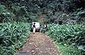
Rainforest trekking is one of São Tomé's attractions
-
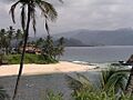
Beach scenery on São Tomé.
-
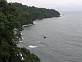
Coastline of Bioko
-
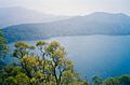
Lake Oku is a crater lake on the plateau.
-
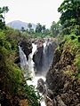
Menchum Falls in the Northwest Province
See also
 In Spanish: Cordillera de Camerún para niños
