Cape Palmas facts for kids
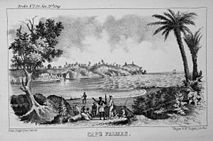
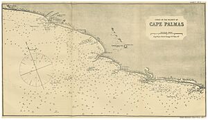
Cape Palmas is a special place located at the very southeastern tip of Liberia, a country in Africa. Think of it as a small, rocky finger of land (a peninsula) that sticks out into the ocean. This peninsula is connected to the main land by a narrow strip of sand called an isthmus.
Right next to Cape Palmas, on its western side, you'll find where the Hoffman River meets the sea. This area is called an estuary. If you travel about 21 kilometers (15 miles) east along the coast, you'll reach the Cavalla River. This river is important because it forms the border between Liberia and another country, the Côte d'Ivoire. Cape Palmas also marks the western edge of a large bay called the Gulf of Guinea.
When you approach Cape Palmas from the sea, you can spot a few interesting things. There's a small, oval-shaped island called Russwurm Island. It was named after John Brown Russwurm, who was the first black governor of a place called Maryland in Africa (which later became part of Liberia). This island is connected to the peninsula by a breakwater, which is like a wall built to protect the coast. You'll also see a lighthouse that helps ships avoid dangerous shallow areas called shoals. From the sea, you might also notice a white building with a large golden ball on its roof. This is a special meeting hall for a group called the Masons, located in the city of Harper, Liberia.
Where Did the Name Cape Palmas Come From?
Back in 1458, a famous explorer from Portugal named Prince Henry the Navigator sent his captain, Diogo Gomes, on a journey. Gomes sailed along the coast of West Africa and reached this cape. He noticed that at this point, the coastline changed direction, turning sharply to the east.
Because of the many palm trees in the area, Gomes named this spot Cabo das Palmas, which means "Cape of the Palms" in Portuguese. Later, this name was changed slightly to Cape Palmas. The river nearby was also named Rio das Palmas, which we now call the Hoffman River. The name Cape Palmas first appeared on maps of Africa as early as 1502, on a map called the Cantino planisphere.
A Look Back in Time: The History of Cape Palmas
In December 1831, the government of Maryland in the United States decided to help free African Americans and former slaves move to Africa. They set aside money for this purpose, and a group called the Maryland State Colonization Society was formed.
An American teacher named Elizabeth Mars Johnson Thomson taught at Cape Palmas from 1835 until 1862. She passed away there in 1864.
The Maryland State Colonization Society decided to create their own settlement for these new arrivals. On February 12, 1834, they established a colony called Maryland in Africa, with Cape Palmas at its center. This colony became a state on February 2, 1841, and then gained its independence on May 29, 1854. However, on March 18, 1857, the state of Maryland in Africa joined the Republic of Liberia and became part of it.
Harper: The Main City of Cape Palmas
The city of Harper, Liberia was founded in 1835 by the Maryland State Colonization Society. It stretches inland along the Hoffman River estuary, which provides a small natural harbor. There's also a settlement called Hoffman Station on the other side of the river.
Often, when people say "Cape Palmas," they are talking about the whole surrounding area of Maryland County. It's also very common for the name Cape Palmas to be used almost like another name for Harper, which is the main city and capital of the county.
 | Delilah Pierce |
 | Gordon Parks |
 | Augusta Savage |
 | Charles Ethan Porter |


