
Herbert Hoover Dike facts for kids


The Herbert Hoover Dike is a large dike built around Lake Okeechobee in Florida. It helps control the water levels in the lake and protects nearby communities from floods.
Contents
History of the Dike
In the early 1900s, a smaller dirt wall was built around Lake Okeechobee. But this wall broke during two big storms, the Great Miami Hurricane in 1926 and the 1928 Okeechobee Hurricane. These storms caused terrible floods and thousands of lives were lost.
After these disasters, the state of Florida decided to work with the U.S. Army Corps of Engineers. Their goal was to build a much stronger system to prevent future floods. President Herbert Hoover even visited the area to see the damage himself.
Because of this, a new plan was made to build bigger walls, called levees, around the lake. This new system was designed to control floods, save water, stop saltwater from getting into fresh water, and protect animals and plants.
In the 1930s, a larger system of levees was built. Then, after more heavy rains and floods in 1947, the dike was made even bigger in the 1960s. This is the Herbert Hoover Dike we see today.
The dike almost completely surrounds the lake. There's only one small break in the dike at Fisheating Creek. Here, the dike goes inland a bit, following the creek. This makes Fisheating Creek the only natural river that still flows into Lake Okeechobee. Building the dike cost about US$165 million. Today, the dike is about 30 feet (9 meters) tall on average. While it's designed to protect against future floods, some people worry that parts of it need repairs.
A special path for bikes, called the Lake Okeechobee Scenic Trail, was opened on top of the dike in 1993. It's part of a much longer trail in Florida.
Environment Around the Lake
Over the years, controlling the water levels around Lake Okeechobee has sometimes caused problems for the environment. For example, in 2016, there was a big bloom of algae in the lake. This happened partly because the natural flow of rivers from the lake was stopped, which usually helps to wash the algae out to sea. Also, water running off from farms and other areas has made the lake's water quality worse over time.
The U.S. Army Corps of Engineers and the Dike
The Herbert Hoover Dike is a key part of a larger project called the Central and Southern Florida (C&SF) Project. This big project helps control floods and manage water in central and south Florida. It was approved by the United States Congress through various laws over many years, starting in 1930.
The Herbert Hoover Dike system includes about 143 miles of levees around Lake Okeechobee. It also has 32 special gates and structures to control water. The very first dirt walls around the lake were built around 1915. But as mentioned, these walls were too small and broke during the hurricanes of 1926 and 1928, leading to many deaths.
After these tragedies, the U.S. Army Corps of Engineers built stronger levees between 1932 and 1938. These new levees were taller, reaching heights of 32 to 35 feet. But after another major hurricane in 1947, it was clear even more protection was needed.
So, by the late 1960s, the new dike system was finished. The levees were made even taller, up to 41 feet high. This was designed to protect against very large floods. However, in the 1980s and 1990s, engineers found that some parts of the dike had issues with water seeping through or not being stable enough. This meant that during times of very high water, some water could leak through the dike. Because of this, the Corps developed a plan to fix and improve the dike. They are still working on making the dike even safer today.
Images for kids
-
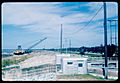
View NNE from atop the Dike from the Canal Point locks during United States Army Corps of Engineers rehabilitation, Canal Point, Florida, 1968.
-
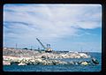
View south of Dike during United States Army Corps of Engineers rehabilitation. Lake Okeechobee is to the right. Canal Point, Florida, 1968.
-
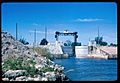
View ESE of Dike Canal Point locks and SCFE train bridge over the West Palm Beach Canal during US Army Corps of Engineers rehabilitation. Lake Okeechobee is behind the photographer. Canal Point, Florida, 1968.
-
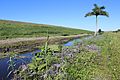
View of the Dike in Canal Point, Florida, along catchment ditch, with Roystonea palm in distance.
-
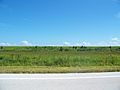
View of the Dike in Glades County from Florida State Road 78, south of the Brighton Seminole Indian Reservation


