Fisheating Creek facts for kids
Quick facts for kids Fisheating Creek |
|
|---|---|

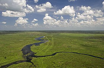
Aerial view
|
|
| Country | United States |
| State | Florida |
| Physical characteristics | |
| Main source | 27°19′58″N 81°32′19″W / 27.33278°N 81.53861°W |
| River mouth | Fisheating Bay, Lake Okeechobee 2 m (6 ft 7 in) 26°58′15″N 81°06′02″W / 26.97083°N 81.10056°W |
Fisheating Creek is a special stream in Florida that flows into Lake Okeechobee. It's unique because it's the only natural river that still flows freely into the lake. It's also the second-biggest natural water source for Lake Okeechobee.
Most of the land around Fisheating Creek is protected. This means it's either owned by the public or has special rules to stop building and keep it natural. The lower part of the creek is still wild and beautiful. People are working hard to make the upper part of the creek natural again, too.
About Fisheating Creek
The name Fisheating Creek comes from the Seminole people. On an old map from 1839, it was called Thlothlopopka-Hatchee. This means "the river where fish are eaten."
Fisheating Creek is about 40 miles (64 km) to 51 miles (82 km) long. It starts in the Cypress Swamp area of Highlands County. Then it flows south into Glades County. About 1 mile (1.6 km) north of County Road 731, it turns east. From there, it flows for about 30 miles (48 km) until it reaches Lake Okeechobee.
Before it enters the lake, the creek spreads out into a marsh called Cowbone Marsh. This marsh is about 8 miles (13 km) long. Fisheating Creek provides almost 9% of the water that flows into Lake Okeechobee. Only the Kissimmee River brings more natural water to the lake.
Where the Creek Begins
Fisheating Creek used to start in a series of marshes in Highlands County. These marshes were west of Lake Placid. Each marsh would overflow into the next one, forming the creek.
In the 1900s, people dug ditches and a canal. This drained the marshes so the land could be used for farming. But now, there are plans to bring these marshes back. In 2010, the United States Department of Agriculture bought rights to 26,000 acres (110 km2) of land. This land is in Highlands County, south of State Road 70. The goal is to restore this area to its natural marshy state.
The Creek's Surroundings
Fisheating Creek flows through many different types of land. You can find dry and wet prairies, flatwoods, and freshwater marshes. There are also hammocks, forests along the river, and swamps that flood.
People have also changed some areas. They've created pastures for animals and planted eucalyptus and pine trees. In 1842, someone described Fisheating Creek as a large stream. They said it changed from a wide river to a small brook and was very winding.
Lake Okeechobee's water level is now kept lower than it used to be. This is because of human changes. As a result, much of Cowbone Marsh has been drained and turned into farmland.
The Herbert Hoover Dike
Lake Okeechobee is almost completely surrounded by a large wall called the Herbert Hoover Dike. The only place where the dike has a gap is at Fisheating Creek. Here, the dike turns away from the lake and runs alongside the creek for several miles. This makes Fisheating Creek the only natural river that still flows freely into Lake Okeechobee. The Lake Okeechobee Scenic Trail runs along the Herbert Hoover Dike.
Wildlife and Protected Areas
Most of Fisheating Creek is inside the Fisheating Creek Wildlife Management Area. The only towns nearby are Palmdale, where U.S. Route 27 crosses the creek, and Lakeport, near where the creek meets Lake Okeechobee.
Many rare animals live in the Fisheating Creek area. Protecting this ecosystem is very important for animals like Florida panthers, black bears, swallow-tailed kites, whooping cranes, sandhill cranes, and crested caracaras.
History of the Area
People from the Belle Glade culture lived around Fisheating Creek a very long time ago. They were here as early as 1000 BCE. Many old archaeological sites from that time have been found here. The most famous one is Fort Center. People lived at Fort Center from before 450 BCE until about 1700.
Fort Center and Early Explorers
During the Second Seminole War (1835–1843), a fort called "Fort Center" was built on the banks of Fisheating Creek. It was a fence made of cabbage-palm tree trunks. The archaeological site is named after this old fort.
In 1842, a group of 83 sailors and marines went on an expedition. They traveled in dugout canoes from Key Biscayne through the Everglades, across Lake Okeechobee, and up Fisheating Creek. They went as far as they could go on the creek. Fort Center was empty then, so the group had to fix it up to stay there for a few days. They found signs that Seminoles had lived in the area, but they didn't meet any during their 60-day trip.
Fort Center was used again during the Third Seminole War (1853–55). It was a stop on a military road that went from Fort Myers to Fort Jupiter. Part of this route involved crossing Lake Okeechobee by canoe.
Seminole People and New Settlements
In 1881, a survey showed that Fisheating Creek was one of five main areas where Seminole people lived in Florida. But in the 1900s, more non-Indian settlers started moving into the area. Lakeport, a town near the mouth of Fisheating Creek, was founded in 1915. By 1930, the Seminoles had been forced out of most of the Fisheating Creek area due to new development. The Brighton Seminole Indian Reservation, which was created in 1935, is in Glades County right next to Fisheating Creek.
Modern History and Public Access
Early in the 1900s, a company called Lykes Brothers, Inc. bought the land around Fisheating Creek. They used it mostly for raising cattle. This company owned a huge amount of land in Glades County. For many years, Lykes Brothers allowed the public to visit Fisheating Creek and the land around it. There was a park, a campground, and a place to rent canoes at Palmdale. They also leased 76,000 acres (310 km2) of land to the state of Florida for hunting.
Changes in Public Access
In the 1980s, Lykes Brothers started closing off public access to their land along Fisheating Creek. This was likely because of more vandalism and illegal hunting. In 1987, Lykes Brothers did not renew the state's lease for the Wildlife Management Area. Instead, they leased the land to a private company that charged fees for hunting. In 1989, Lykes closed the park, campground, and canoe rental area. They also put up fences and gates to block roads that people used to access the land. They even put logs and other things in Fisheating Creek to stop boats from passing.
Legal Battle for the Creek
In March 1989, people living in Glades County broke open a gate that Lykes Brothers had put up. The Glades County Commission then ordered the gate and a nearby fence to be removed with a bulldozer. They said the land belonged to the county. Lykes Brothers then sued the county.
The legal fight mainly focused on whether Fisheating Creek was a navigable waterway. If a stream is navigable, it means its bed, up to the high water mark, belongs to the state. In 1998, a court decided that Fisheating Creek was navigable. This meant the creek bed belonged to Florida. Lykes Brothers planned to appeal this decision. However, Florida and Lykes Brothers agreed to a settlement to end the lawsuit.
The Settlement and Protection
As part of the settlement, Florida paid $46.4 million to Lykes Brothers. With this money, Florida bought 18,272 acres (73.94 km2) of land along the creek. This land became the Fisheating Creek Wildlife Management Area (WMA). The state also bought special rights to another 41,523 acres (168.04 km2) of Lykes Brothers' land. These rights mean that the land must be protected and cannot be developed.
The settlement also requires the state to keep a clear path for boats in Fisheating Creek. This path goes from Lake Okeechobee to the U.S. Route 27 bridge at Palmdale. To protect the wildlife, motor vehicles and jet-powered boats are not allowed in the WMA. Airboats are also banned from parts of Cowbone Marsh. Hunting is allowed in the WMA, but it is limited.
 | Jewel Prestage |
 | Ella Baker |
 | Fannie Lou Hamer |


