Bridgeport, Alabama facts for kids
Quick facts for kids
Bridgeport
|
|
|---|---|

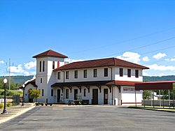
Bridgeport Depot
|
|

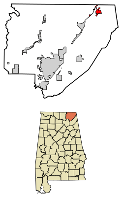
Location of Bridgeport in Jackson County, Alabama.
|
|
| Country | United States |
| State | Alabama |
| County | Jackson |
| Area | |
| • Total | 4.46 sq mi (11.54 km2) |
| • Land | 4.33 sq mi (11.21 km2) |
| • Water | 0.13 sq mi (0.33 km2) |
| Elevation | 673 ft (205 m) |
| Population
(2020)
|
|
| • Total | 2,264 |
| • Density | 523.11/sq mi (201.96/km2) |
| Time zone | UTC-6 (Central (CST)) |
| • Summer (DST) | UTC-5 (CDT) |
| ZIP code |
35740
|
| Area code(s) | 256 |
| FIPS code | 01-09328 |
| GNIS feature ID | 0114905 |
Bridgeport is a city in Jackson County, Alabama, United States. In 2020, about 2,264 people lived there. This was a small decrease from 2,418 people in 2010. Bridgeport is part of a larger area that includes Chattanooga, Tennessee.
Contents
History of Bridgeport
Bridgeport started growing in the 1840s. European settlers created a landing here for riverboats. This spot on the Tennessee River was where local farmers could trade their crops. Soon, a small village called "Jonesville" grew around the landing. It had a trading post, a mill, warehouses, and saloons. The Jonesville post office opened in 1852.
Railroads and a New Name
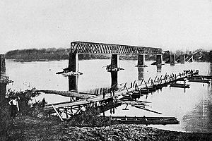
Riverboat trade was not always reliable because the river's water level changed. So, merchants wanted a railroad. The first train line reached Jonesville in 1852. A railroad bridge was built over the Tennessee River in 1854. This bridge connected the town with Chattanooga, Tennessee. Because of this important bridge, the town's name was changed to "Bridgeport." Another rail line to Jasper, Tennessee, started in 1860. It was finished after the Civil War.
Bridgeport During the Civil War
Bridgeport was a very important place during the Civil War. This was because it had both a railroad and the Tennessee River. The rail bridge was a target in November 1861. It was burned down twice during the war.
Bridgeport saw many small battles in 1862 and 1863. Union General Ormsby Mitchel took control of the city. Confederate forces tried to get it back. Confederate troops under General Braxton Bragg burned the city in the summer of 1863. But Union forces quickly took it back. Later in the war, Bridgeport became a major Union shipyard. They built gunboats and transport boats there. The USS Chattanooga was built here. It helped break the Confederates' siege of Chattanooga in November 1863.
Growth and Challenges
In the early 1880s, the Kilpatrick family from New York started a lumber company. They believed Bridgeport had great potential to grow. They bought a lot of land in the area. Other investors became interested too. In 1889, the Bridgeport Land and Development Company was formed. This company bought land and planned a new layout for the city. Bridgeport officially became a city in 1891.
Frank Kilpatrick became the city's mayor. He built many large Queen Anne-style houses. These houses are still on Kilpatrick Row today. Several factories were built along the river. These included places that made pipes, stoves, and train cars. But Bridgeport's fast growth stopped suddenly in 1893. This was due to a financial crisis called the Panic of 1893. Investors left, and the development company closed.
Frank Kilpatrick returned in 1895. He helped bring some new businesses to the city. The beautiful Mission Revival-style Bridgeport Depot was finished in 1917. By the 1920s, two hosiery (sock) mills were open. In the 1950s, the nearby Widows Creek Power Plant was built. This brought more people and homes to Bridgeport.
On January 22, 1999, a gas pipeline exploded in downtown Bridgeport. This serious accident damaged several buildings and affected many people. It happened because the pipeline was accidentally hit during digging, causing gas to leak and ignite.
Geography of Bridgeport
Bridgeport covers about 3.2 square miles (8.3 square kilometers). Most of this area is land, with a small part being water. The city is on the western bank of the Tennessee River. This part of the river is called Guntersville Lake. The lake is formed by Guntersville Dam, which is about 60 miles downstream.
To the northwest, you can see the Cumberland Plateau. Across the river to the east is Sand Mountain. U.S. Route 72 connects Bridgeport to South Pittsburg, Tennessee, to the north. It also connects to Stevenson, Alabama, to the southwest.
Russell Cave National Monument is also located near Bridgeport.
Climate in Bridgeport
Bridgeport has hot, humid summers. Its winters are usually mild to cool. This type of weather is called a humid subtropical climate. It's often shown as "Cfa" on climate maps.
| Climate data for Russell Cave National Monument (5 miles northwest of Bridgepoint) (1991–2020 normals, extremes 1955–present) | |||||||||||||
|---|---|---|---|---|---|---|---|---|---|---|---|---|---|
| Month | Jan | Feb | Mar | Apr | May | Jun | Jul | Aug | Sep | Oct | Nov | Dec | Year |
| Record high °F (°C) | 76 (24) |
81 (27) |
86 (30) |
91 (33) |
97 (36) |
100 (38) |
102 (39) |
105 (41) |
102 (39) |
97 (36) |
88 (31) |
77 (25) |
105 (41) |
| Mean daily maximum °F (°C) | 48.4 (9.1) |
53.0 (11.7) |
62.1 (16.7) |
71.3 (21.8) |
78.2 (25.7) |
84.8 (29.3) |
87.7 (30.9) |
87.2 (30.7) |
82.1 (27.8) |
71.6 (22.0) |
60.2 (15.7) |
51.3 (10.7) |
69.8 (21.0) |
| Daily mean °F (°C) | 38.8 (3.8) |
42.6 (5.9) |
50.4 (10.2) |
58.7 (14.8) |
67.0 (19.4) |
74.2 (23.4) |
77.6 (25.3) |
76.8 (24.9) |
71.2 (21.8) |
59.7 (15.4) |
49.0 (9.4) |
41.5 (5.3) |
59.0 (15.0) |
| Mean daily minimum °F (°C) | 29.1 (−1.6) |
32.2 (0.1) |
38.7 (3.7) |
46.0 (7.8) |
55.7 (13.2) |
63.6 (17.6) |
67.5 (19.7) |
66.4 (19.1) |
60.3 (15.7) |
47.8 (8.8) |
37.7 (3.2) |
31.7 (−0.2) |
48.1 (8.9) |
| Record low °F (°C) | −13 (−25) |
−4 (−20) |
9 (−13) |
22 (−6) |
23 (−5) |
38 (3) |
49 (9) |
46 (8) |
32 (0) |
21 (−6) |
10 (−12) |
−6 (−21) |
−13 (−25) |
| Average precipitation inches (mm) | 5.64 (143) |
5.66 (144) |
5.72 (145) |
5.74 (146) |
4.16 (106) |
4.75 (121) |
5.42 (138) |
4.01 (102) |
4.43 (113) |
3.63 (92) |
4.90 (124) |
6.18 (157) |
60.24 (1,530) |
| Source: NOAA | |||||||||||||
People of Bridgeport (Demographics)
| Historical population | |||
|---|---|---|---|
| Census | Pop. | %± | |
| 1900 | 1,247 | — | |
| 1910 | 2,125 | 70.4% | |
| 1920 | 2,018 | −5.0% | |
| 1930 | 2,124 | 5.3% | |
| 1940 | 2,031 | −4.4% | |
| 1950 | 2,386 | 17.5% | |
| 1960 | 2,906 | 21.8% | |
| 1970 | 2,908 | 0.1% | |
| 1980 | 2,974 | 2.3% | |
| 1990 | 2,936 | −1.3% | |
| 2000 | 2,728 | −7.1% | |
| 2010 | 2,418 | −11.4% | |
| 2020 | 2,264 | −6.4% | |
| U.S. Decennial Census 2013 Estimate |
|||
2010 Census Information
In 2010, Bridgeport had 2,418 people living in 1,012 homes. About 686 of these were families. The city had about 755 people per square mile. Most residents (84%) were White. About 8.6% were Black or African American. Other groups included Native American, Asian, and people of two or more races. About 1.7% of the population was Hispanic or Latino.
About 26.4% of homes had children under 18. About 45% were married couples. The average household had 2.39 people. The average family had 2.89 people. The median age in Bridgeport was 40.5 years old.
2020 Census Information
| Race | Num. | Perc. |
|---|---|---|
| White (non-Hispanic) | 1,851 | 81.76% |
| Black or African American (non-Hispanic) | 190 | 8.39% |
| Native American | 30 | 1.33% |
| Asian | 10 | 0.44% |
| Other/Mixed | 151 | 6.67% |
| Hispanic or Latino | 32 | 1.41% |
As of the 2020 United States census, there were 2,264 people living in Bridgeport. There were 1,031 households and 586 families.
Culture and Fun
The Bridgeport Depot Museum is a great place to visit. It has old railroad items and other local artifacts. The museum is in the town's fourth railroad depot, built in 1917.
Every April, Bridgeport hosts a special event. It's a reenactment of the Siege of Bridgeport. This helps people remember the city's role in the Civil War.
See also
 In Spanish: Bridgeport (Alabama) para niños
 | Ernest Everett Just |
 | Mary Jackson |
 | Emmett Chappelle |
 | Marie Maynard Daly |


