South Pittsburg, Tennessee facts for kids
Quick facts for kids
South Pittsburg, Tennessee
|
|
|---|---|

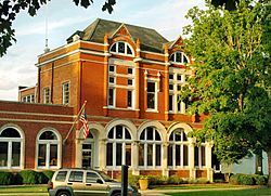
South Pittsburg City Hall
|
|

Location of South Pittsburg in Marion County, Tennessee.
|
|
| Country | United States |
| State | Tennessee |
| County | Marion |
| Area | |
| • Total | 8.22 sq mi (21.29 km2) |
| • Land | 8.22 sq mi (21.29 km2) |
| • Water | 0 sq mi (0.00 km2) |
| Elevation | 633 ft (193 m) |
| Population
(2020)
|
|
| • Total | 3,106 |
| • Density | 377.86/sq mi (145.89/km2) |
| Time zone | UTC-6 (Central (CST)) |
| • Summer (DST) | UTC-5 (CDT) |
| ZIP code |
37380
|
| Area code(s) | 423 |
| FIPS code | 47-70060 |
| GNIS feature ID | 1314091 |
South Pittsburg is a city in Marion County, Tennessee, United States. It is part of the larger Chattanooga area. In 2020, about 3,106 people lived there. South Pittsburg is famous for hosting the National Cornbread Festival every year.
Contents
History of South Pittsburg
Early Days and Railroads
For a long time, the area where South Pittsburg is now was mostly farmland. This changed in the late 1860s when a railroad line was built into the Sequatchie Valley. Soon after, small mining operations started. In 1869, a post office opened, and the community was called Battle Creek Mines.
A New Name and Big Dreams
In the mid-1870s, some investors from Britain wanted to build a large industrial area in the Sequatchie Valley. They sent James Bowron to find the best spots. He chose the Battle Creek Mines area to be a center for making iron and a business hub. This spot was great because it was close to both the railroad and the Tennessee River.
On May 23, 1876, the name of Battle Creek Mines was changed to "South Pittsburg." People hoped the city would grow to be a huge iron-making center, just like Pittsburgh, Pennsylvania.
Growth and Challenges
After some changes in leadership, a new company called the Tennessee Coal, Iron and Railroad Company (TCI) took over in 1882. They continued to build mines and iron factories. In 1886, a banker named William Duncan bought the land where South Pittsburg was planned. He helped create the South Pittsburg City Company. The city was officially started in 1887.
Around this time, two large blast furnaces and a foundry were finished. These allowed the city to start making iron on a large scale. South Pittsburg grew quickly in the 1890s. However, it faced challenges when TCI moved its main operations to Alabama.
Richard City and Cement Production
In 1906, the Dixie-Portland Cement Company started making cement in an area south of South Pittsburg. This area became known as "Richard City," named after Richard Hardy, an executive who helped build the company town. Many of the buildings in Richard City, like houses and churches, were made using the company's own cement. The cement plant worked until 1980. In 1985, Richard City became part of South Pittsburg.
Geography of South Pittsburg
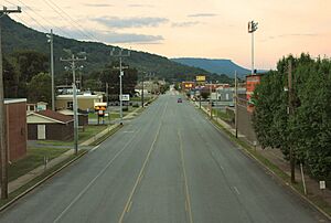
South Pittsburg is located at 35°0′30″N 85°42′38″W / 35.00833°N 85.71056°W. The city sits in the southwestern part of the Sequatchie Valley. To the west are the mountains of the Cumberland Plateau, and to the east is the Tennessee River. The city is surrounded by two steep ridges, Whitacre Point and Lodge Point.
South Pittsburg is about 633 feet (193 meters) above sea level. This makes it the lowest city in the eastern part of Tennessee. The city's southern border reaches the state line with Alabama. Nearby towns include Kimball to the north and New Hope across the river to the east. Chattanooga is about 25 miles (40 km) to the east.
Roads and Transportation
- U.S. Route 72 goes through South Pittsburg, connecting it to Jasper in the north and Bridgeport, Alabama in the south.
- Tennessee State Route 156 crosses the river on the Shelby Reinhart Bridge. It connects the city to New Hope and Haletown to the east. It also leads to the Sewanee and Monteagle areas on top of the Plateau to the west.
- Interstate 24 passes through Kimball, which is just north of South Pittsburg.
The city covers about 5.9 square miles (15.3 square kilometers) of land.
Population of South Pittsburg
| Historical population | |||
|---|---|---|---|
| Census | Pop. | %± | |
| 1880 | 1,045 | — | |
| 1890 | 1,479 | 41.5% | |
| 1900 | 1,789 | 21.0% | |
| 1910 | 2,106 | 17.7% | |
| 1920 | 2,356 | 11.9% | |
| 1930 | 2,103 | −10.7% | |
| 1940 | 2,285 | 8.7% | |
| 1950 | 2,573 | 12.6% | |
| 1960 | 4,130 | 60.5% | |
| 1970 | 3,613 | −12.5% | |
| 1980 | 3,636 | 0.6% | |
| 1990 | 3,295 | −9.4% | |
| 2000 | 3,295 | 0.0% | |
| 2010 | 2,992 | −9.2% | |
| 2020 | 3,106 | 3.8% | |
| Sources: | |||
2020 Census Information
In 2020, there were 3,106 people living in South Pittsburg. There were 1,251 households and 734 families.
| Race | Number | Percentage |
|---|---|---|
| White (not Hispanic) | 2,252 | 72.5% |
| Black or African American (not Hispanic) | 565 | 18.19% |
| Native American | 10 | 0.32% |
| Asian | 36 | 1.16% |
| Other/Mixed | 176 | 5.67% |
| Hispanic or Latino | 67 | 2.16% |
Famous People from South Pittsburg
- Chris Jones - A head coach for the Edmonton Elks in the Canadian Football League.
- James M. Lewis - A pharmacist and a state senator in Tennessee.
- Eddie Moore - An NFL linebacker, a type of football player.
- Jobyna Ralston - A famous silent film actress.
See also
 In Spanish: South Pittsburg (Tennessee) para niños
 | Toni Morrison |
 | Barack Obama |
 | Martin Luther King Jr. |
 | Ralph Bunche |


