Monteagle, Tennessee facts for kids
Quick facts for kids
Monteagle, Tennessee
|
|
|---|---|

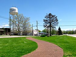
Greenway and water tower in Monteagle
|
|

Location of Monteagle in Franklin, Grundy, and Marion counties Tennessee.
|
|
| Country | United States |
| State | Tennessee |
| Counties | Grundy, Marion, Franklin |
| Founded | 1870 |
| Incorporated | 1962 |
| Named for | Eagles that once lived in the area |
| Area | |
| • Total | 9.15 sq mi (23.71 km2) |
| • Land | 9.04 sq mi (23.42 km2) |
| • Water | 0.11 sq mi (0.29 km2) |
| Elevation | 1,926 ft (587 m) |
| Population
(2020)
|
|
| • Total | 1,393 |
| • Density | 154.02/sq mi (59.47/km2) |
| Time zone | UTC-6 (Central (CST)) |
| • Summer (DST) | UTC-5 (CDT) |
| ZIP code |
37356
|
| Area code(s) | 931, 423 |
| FIPS code | 47-49740 |
| GNIS feature ID | 1314141 |
Monteagle is a small town in the state of Tennessee, in the United States. It is located in the southeastern part of the state. The town is spread across three different counties: Franklin, Grundy, and Marion.
In 2020, about 1,393 people lived in Monteagle. Most of the town's residents live in Grundy County. Monteagle is known for its location on the Cumberland Plateau.
One of the most famous things about Monteagle is the challenging stretch of Interstate 24 that goes through it. This part of the highway is often called "The Monteagle" or "Monteagle Mountain". It is a major landmark for drivers traveling between Chattanooga and Nashville. Sometimes, bad weather can cause the interstate to close. When this happens, traffic is sent onto U.S. Route 41.
Monteagle has also been mentioned in popular culture. The country singer Jerry Reed sang about surviving brake failure on the "Monteagle Grade" in his song "The Legend". This song was featured in the movie Smokey and the Bandit. Johnny Cash also has a song called "Monteagle Mountain".
The town is home to important places like the DuBose Conference Center and the Monteagle Sunday School Assembly. The Highlander Folk School, which played a big role in the civil rights movement, was also located here for many years. Famous civil rights leader Rosa Parks attended workshops at the school.
Contents
History of Monteagle
Monteagle has always been an important place for crossing the Cumberland Plateau. This is because it is located on a narrow part of the plateau in southern Tennessee. In 1838, one of the last groups of Cherokee people, who were being forced to move from their homes, passed through this area. They were on their way to Oklahoma as part of the Trail of Tears.
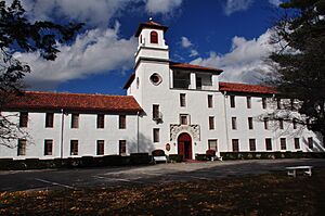
The town was first called "Moffat Station". It was named after John Moffat, who was a Scottish-Canadian activist. He bought a lot of land in the area in 1870. In 1872, Moffat gave 50 acres (20 hectares) of land to Fairmount College. This was a women's college that moved to Monteagle from Jackson, Mississippi. Today, the land where the college once stood is home to the DuBose Conference Center.
In 1882, the Monteagle Sunday School Assembly was started. This assembly was inspired by the Chautauqua Institution. Its goal was to train Sunday school teachers.
Over time, the town's name changed. It went from "Moffat Station" to "Mount Eagle", then to "Mounteagle". By the time the town officially became a town in 1962, its name was spelled "Monteagle".
Geography and Climate
Monteagle is located where Grundy, Marion, and Franklin counties meet. The line between Marion and Grundy counties runs right through the middle of the town.
The town sits on a narrow part of the Cumberland Plateau. People often call this area "Monteagle Mountain". This part of the plateau is about 2 miles (3.2 km) wide. It has steep drops on both the northwest and southeast sides. Monteagle is nearly 2,000 feet (610 meters) above sea level. In comparison, nearby cities like Cowan and South Pittsburg are much lower, less than 1,000 feet (300 meters) above sea level.
Interstate 24 goes through Monteagle. You can get on or off the interstate at Exits 134 and 135. I-24 leads northwest to Nashville and southeast to Chattanooga. U.S. Route 41 is the main street in Monteagle. It goes east to Tracy City and northwest to Manchester. Another road, U.S. Route 41A, branches off from US 41 in Monteagle. It goes southwest to Sewanee.
The town has a total area of about 9.15 square miles (23.71 square kilometers). Most of this area is land, with a small amount of water. Water from the north side of town flows into the Elk River. Water from the south side flows into Battle Creek. Both of these eventually reach the Tennessee River.
Monteagle's Climate
Monteagle has a humid subtropical climate. This is common for Tennessee. However, it also has a lot of rain, making it similar to a temperate rainforest. This type of climate is more typical of the southern Blue Ridge Mountains.
| Climate data for Monteagle, Tennessee (1991–2020 normals, extremes 1938–present) | |||||||||||||
|---|---|---|---|---|---|---|---|---|---|---|---|---|---|
| Month | Jan | Feb | Mar | Apr | May | Jun | Jul | Aug | Sep | Oct | Nov | Dec | Year |
| Record high °F (°C) | 73 (23) |
80 (27) |
82 (28) |
88 (31) |
95 (35) |
100 (38) |
101 (38) |
99 (37) |
98 (37) |
91 (33) |
81 (27) |
73 (23) |
101 (38) |
| Mean maximum °F (°C) | 64.0 (17.8) |
67.6 (19.8) |
74.7 (23.7) |
80.5 (26.9) |
83.4 (28.6) |
87.9 (31.1) |
89.6 (32.0) |
89.0 (31.7) |
85.9 (29.9) |
79.7 (26.5) |
72.3 (22.4) |
63.7 (17.6) |
91.2 (32.9) |
| Mean daily maximum °F (°C) | 44.3 (6.8) |
48.7 (9.3) |
57.3 (14.1) |
66.8 (19.3) |
73.8 (23.2) |
80.3 (26.8) |
83.2 (28.4) |
82.7 (28.2) |
78.0 (25.6) |
67.8 (19.9) |
56.7 (13.7) |
47.9 (8.8) |
65.6 (18.7) |
| Daily mean °F (°C) | 35.4 (1.9) |
39.3 (4.1) |
47.1 (8.4) |
56.0 (13.3) |
63.8 (17.7) |
70.8 (21.6) |
74.0 (23.3) |
73.3 (22.9) |
68.1 (20.1) |
57.3 (14.1) |
46.8 (8.2) |
39.1 (3.9) |
55.9 (13.3) |
| Mean daily minimum °F (°C) | 26.4 (−3.1) |
29.8 (−1.2) |
36.8 (2.7) |
45.2 (7.3) |
53.8 (12.1) |
61.3 (16.3) |
64.8 (18.2) |
64.0 (17.8) |
58.2 (14.6) |
46.7 (8.2) |
36.8 (2.7) |
30.3 (−0.9) |
46.2 (7.9) |
| Mean minimum °F (°C) | 7.1 (−13.8) |
12.9 (−10.6) |
18.9 (−7.3) |
29.4 (−1.4) |
38.8 (3.8) |
51.0 (10.6) |
57.3 (14.1) |
56.6 (13.7) |
44.5 (6.9) |
31.1 (−0.5) |
21.1 (−6.1) |
14.2 (−9.9) |
4.4 (−15.3) |
| Record low °F (°C) | −20 (−29) |
−8 (−22) |
1 (−17) |
19 (−7) |
30 (−1) |
40 (4) |
48 (9) |
44 (7) |
33 (1) |
21 (−6) |
−7 (−22) |
−9 (−23) |
−20 (−29) |
| Average precipitation inches (mm) | 5.68 (144) |
5.77 (147) |
6.31 (160) |
6.26 (159) |
5.31 (135) |
5.76 (146) |
6.40 (163) |
4.75 (121) |
4.59 (117) |
4.09 (104) |
5.22 (133) |
6.82 (173) |
66.96 (1,701) |
| Average snowfall inches (cm) | 1.5 (3.8) |
1.9 (4.8) |
0.8 (2.0) |
0.0 (0.0) |
0.0 (0.0) |
0.0 (0.0) |
0.0 (0.0) |
0.0 (0.0) |
0.0 (0.0) |
0.0 (0.0) |
0.1 (0.25) |
1.1 (2.8) |
5.4 (14) |
| Average precipitation days (≥ 0.01 in) | 12.8 | 12.3 | 12.8 | 11.6 | 11.9 | 12.5 | 12.8 | 11.0 | 8.6 | 9.1 | 10.1 | 13.0 | 138.5 |
| Average snowy days (≥ 0.1 in) | 1.1 | 1.1 | 0.6 | 0.0 | 0.0 | 0.0 | 0.0 | 0.0 | 0.0 | 0.0 | 0.1 | 0.7 | 3.6 |
| Source: NOAA | |||||||||||||
Population Data
Monteagle's population has changed over the years. Here's a look at how many people have lived there during different census counts:
| Historical population | |||
|---|---|---|---|
| Census | Pop. | %± | |
| 1970 | 934 | — | |
| 1980 | 1,126 | 20.6% | |
| 1990 | 1,138 | 1.1% | |
| 2000 | 1,238 | 8.8% | |
| 2010 | 1,192 | −3.7% | |
| 2020 | 1,393 | 16.9% | |
| Sources: | |||
2020 Census Information
In the 2020 United States census, there were 1,393 people living in Monteagle. These people made up 614 households and 458 families. The town is mostly made up of people who identify as White. There are also smaller numbers of people from other racial and ethnic backgrounds.
| Race | Number | Percentage |
|---|---|---|
| White (non-Hispanic) | 1,256 | 90.17% |
| Black or African American (non-Hispanic) | 12 | 0.86% |
| Native American | 1 | 0.07% |
| Asian | 23 | 1.65% |
| Other/Mixed | 67 | 4.81% |
| Hispanic or Latino | 34 | 2.44% |
Places to Visit
Monteagle has a few interesting places to visit:
- DuBose Conference Center: This center is located on the former grounds of Fairmount College.
- Monteagle Sunday School Assembly: This historic assembly was founded to train Sunday school teachers.
- Highlander Folk School: This school was important for the labor and civil rights movements.
Famous People from Monteagle
Some notable individuals have connections to Monteagle:
- Mary Anderson: She invented the windshield wiper.
- May Justus: An award-winning author.
- Edwin A. Keeble: A well-known architect.
- William Millsaps: A presiding bishop in the Episcopal Missionary Church.
- William Alexander Percy: A poet and lawyer who owned a summer house in Monteagle.
See also
 In Spanish: Monteagle (Tennessee) para niños
 | Tommie Smith |
 | Simone Manuel |
 | Shani Davis |
 | Simone Biles |
 | Alice Coachman |


