Magoffin County, Kentucky facts for kids
Quick facts for kids
Magoffin County
|
|
|---|---|

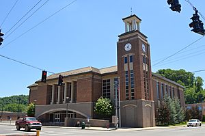
Magoffin County justice center in Salyersville
|
|

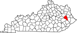
Location within the U.S. state of Kentucky
|
|
 Kentucky's location within the U.S. |
|
| Country | |
| State | |
| Founded | 1860 |
| Named for | Beriah Magoffin |
| Seat | Salyersville |
| Largest city | Salyersville |
| Area | |
| • Total | 309 sq mi (800 km2) |
| • Land | 308 sq mi (800 km2) |
| • Water | 0.7 sq mi (2 km2) 0.2% |
| Population
(2020)
|
|
| • Total | 11,637 |
| • Estimate
(2023)
|
11,228 |
| • Density | 37.66/sq mi (14.541/km2) |
| Time zone | UTC−5 (Eastern) |
| • Summer (DST) | UTC−4 (EDT) |
| Congressional district | 5th |
Magoffin County is a place in Kentucky, a state in the United States. It is a type of local government area called a county. In 2020, about 11,637 people lived here.
The main town and center of the county is Salyersville. Magoffin County was created in 1860. It was formed from parts of nearby Floyd, Johnson, and Morgan Counties. The county is named after Beriah Magoffin. He was the Governor of Kentucky from 1859 to 1862.
Contents
History
How Magoffin County Was Formed
The land that is now Magoffin County has a long history. In 1772, this area was part of a large frontier region called Fincastle County, Virginia. Later, in 1776, it became part of Kentucky County, Virginia.
Over many years, Kentucky County was divided into smaller areas. In 1780, it was split into three counties: Jefferson, Fayette, and Lincoln. Then, Fayette County was divided in 1785, creating Bourbon County.
More divisions happened over time. In 1792, Clark County was formed from Bourbon County. Montgomery County was created in 1796. Then, Fleming County was made in 1798.
Floyd County was created in 1800 from parts of Fleming, Mason, and Montgomery Counties. In 1843, Johnson County was formed. It was carved out of an area that had been Bath County since 1811.
Finally, in 1860, the Kentucky government decided to create Magoffin County. They used parts of Johnson, Floyd, and Morgan Counties to form it. The borders of Magoffin County have stayed the same ever since.
Magoffin County During the Civil War
During the American Civil War, Magoffin County was a "border county." This meant people had mixed feelings about joining the Union or the Confederacy. Most people in the area supported the Union.
About 123 men from Magoffin County joined the Confederate Army. However, more men, around 292, chose to serve in the Union Army. This shows how divided the county was during the war.
Early Industries
As the 1800s ended, Magoffin County became important for its natural resources. It was a major supplier of oil and natural gas. Some of the very first oil wells in Eastern Kentucky were built right here in the county.
Geography
Magoffin County covers a total area of about 309 square miles. Most of this land, about 308 square miles, is dry land. Only a small part, about 0.7 square miles, is water. The Licking River flows through the county.
Neighboring Counties
Magoffin County shares its borders with several other counties:
- Morgan County (to the northwest)
- Johnson County (to the northeast)
- Floyd County (to the southeast)
- Knott County (to the south)
- Breathitt County (to the southwest)
- Wolfe County (to the west)
Population Information
| Historical population | |||
|---|---|---|---|
| Census | Pop. | %± | |
| 1870 | 4,684 | — | |
| 1880 | 6,944 | 48.2% | |
| 1890 | 9,196 | 32.4% | |
| 1900 | 12,006 | 30.6% | |
| 1910 | 13,654 | 13.7% | |
| 1920 | 13,859 | 1.5% | |
| 1930 | 15,719 | 13.4% | |
| 1940 | 17,490 | 11.3% | |
| 1950 | 13,839 | −20.9% | |
| 1960 | 11,156 | −19.4% | |
| 1970 | 10,443 | −6.4% | |
| 1980 | 13,515 | 29.4% | |
| 1990 | 13,077 | −3.2% | |
| 2000 | 13,332 | 1.9% | |
| 2010 | 13,333 | 0.0% | |
| 2020 | 11,637 | −12.7% | |
| 2023 (est.) | 11,228 | −15.8% | |
| U.S. Decennial Census 1790-1960 1900-1990 1990-2000 2010-2021 |
|||
In 2010, there were 13,333 people living in Magoffin County. Most of the people, about 98.6%, were White. A small number were Native American, Black, or Asian. About 0.7% of the population was Hispanic or Latino.
In 2000, the county had 13,332 people. There were 5,024 households, which are groups of people living together. The average household had about 2.62 people.
The population was spread out by age. About 26.8% of people were under 18 years old. About 10.6% were 65 years or older. The average age in the county was 34 years.
Economy
For many years, coal mining was a big part of Magoffin County's economy. The last active coal mine in the county closed in 2015. However, in 2022, the TipTop Coal Mine reopened. This means there is now one coal mine operating in the county.
Today, major employers in Magoffin County include several businesses that transport coal using trucks.
Communities
City
- Salyersville (This is the county seat, meaning it's the main town where the county government is located.)
Unincorporated Communities
These are smaller towns or areas that do not have their own local government.
Education
Magoffin County has one main school system. It is called the Magoffin County School District. This district manages the public schools for children in the county.
Notable People
- Samuel Wilber Hager - He was an important politician from Kentucky. He served as the Kentucky State Treasurer from 1900 to 1904. After that, he was the Kentucky State Auditor from 1904 to 1908. He was also a candidate for governor of Kentucky in 1907.
See also
 In Spanish: Condado de Magoffin para niños
 | Charles R. Drew |
 | Benjamin Banneker |
 | Jane C. Wright |
 | Roger Arliner Young |

