
Floyd County, Kentucky facts for kids
Quick facts for kids
Floyd County
|
|
|---|---|
,_Prestonsburg.jpg)
Floyd County Courthouse
|
|

Location within the U.S. state of Kentucky
|
|
 Kentucky's location within the U.S. |
|
| Country | |
| State | |
| Founded | 1800 |
| Named for | John Floyd |
| Seat | Prestonsburg |
| Largest city | Prestonsburg |
| Area | |
| • Total | 396 sq mi (1,030 km2) |
| • Land | 393 sq mi (1,020 km2) |
| • Water | 2.4 sq mi (6 km2) 0.6%% |
| Population
(2020)
|
|
| • Total | 35,942 |
| • Estimate
(2023)
|
34,423 |
| • Density | 90.76/sq mi (35.04/km2) |
| Time zone | UTC−5 (Eastern) |
| • Summer (DST) | UTC−4 (EDT) |
| Congressional district | 5th |
Floyd County is a county located in the state of Kentucky. In 2020, about 35,942 people lived there. Its main town, or county seat, is Prestonsburg. The county was started in 1800 and is named after Colonel John Floyd.
Contents
History
On December 13, 1799, the lawmakers in Kentucky decided to create Floyd County. It became the 40th county in Kentucky. Parts of Fleming, Montgomery, and Mason County, Kentucky counties were used to form it. This decision became official on June 1, 1800.
The county was named after James John Floyd. He was a pioneer who helped plan the city of Louisville. The county seat was first called Preston's Station, and later renamed Prestonsburg. The first courthouse burned down in 1808. This meant many early records were lost.
During the American Civil War, Prestonsburg was used by the Confederate soldiers. Two battles happened nearby. The Battle of Ivy Mountain was on November 8, 1861. The Battle of Middle Creek was on January 10, 1862. Both battles were won by the Union army.
Since the early 1900s, coal mining has been very important in Floyd County. In 1900, the first commercial coal mine in eastern Kentucky opened in Betsy Layne. Soon, coal became the biggest industry. Many coal towns grew up around the mines. These towns included Wheelwright, Bypro, Emma, Garrett, and Wayland.
By 1950, the county had over 50,000 people. But as coal mining slowed down, many people moved away. This movement is sometimes called the Hillbilly Highway. In 2016, there were still 23 coal mines working in the county. They produced about 640,000 tons of coal.
On February 28, 1958, a very serious bus accident happened in the county. It was near Prestonsburg and 27 people died.
On June 30, 2022, a sad event happened in Allen. Police officers were killed or injured while doing their job. Three officers and a police dog died, and four other people were hurt.
Geography
Floyd County covers a total area of about 396 square miles. Most of this, 393 square miles, is land. The rest, about 2.4 square miles, is water.
Adjacent counties
Floyd County shares borders with these other counties:
- Johnson County (to the north)
- Martin County (to the northeast)
- Pike County (to the east)
- Knott County (to the southwest)
- Magoffin County (to the northwest)
Demographics
| Historical population | |||
|---|---|---|---|
| Census | Pop. | %± | |
| 1810 | 3,485 | — | |
| 1820 | 8,207 | 135.5% | |
| 1830 | 4,347 | −47.0% | |
| 1840 | 6,302 | 45.0% | |
| 1850 | 5,714 | −9.3% | |
| 1860 | 6,388 | 11.8% | |
| 1870 | 7,877 | 23.3% | |
| 1880 | 10,176 | 29.2% | |
| 1890 | 11,256 | 10.6% | |
| 1900 | 15,552 | 38.2% | |
| 1910 | 18,623 | 19.7% | |
| 1920 | 27,427 | 47.3% | |
| 1930 | 41,942 | 52.9% | |
| 1940 | 52,986 | 26.3% | |
| 1950 | 53,500 | 1.0% | |
| 1960 | 41,642 | −22.2% | |
| 1970 | 35,889 | −13.8% | |
| 1980 | 48,764 | 35.9% | |
| 1990 | 43,586 | −10.6% | |
| 2000 | 42,441 | −2.6% | |
| 2010 | 39,451 | −7.0% | |
| 2020 | 35,942 | −8.9% | |
| 2023 (est.) | 34,423 | −12.7% | |
| U.S. Decennial Census 1790-1960 1900-1990 1990-2000 2010-2020 |
|||
In 2010, there were 39,451 people living in Floyd County. Most people, about 98.2%, were White. About 0.7% were Black or African American, and 0.2% were Asian. A small number, 0.6%, were Hispanic or Latino.
In 2000, there were 42,441 people. The county had about 108 people per square mile. There were 16,881 households, and 12,272 families. About 33% of households had children under 18 living with them. The average household had 2.45 people.
The Melungeon families of Kentucky mostly live in Floyd and Magoffin counties. These families have a unique heritage. While some still live in groups, many have moved to other areas.
Education
The public schools in Floyd County are run by the Floyd County School District.
Economy
The economy of Floyd County has been greatly shaped by coal mining.
Coal companies in Floyd County
Some of the coal companies that have operated in Floyd County include:
- Blackhawk Mining
- James River Coal Company
- Frasure Creek Mining
Communities
Cities
- Allen
- Martin
- Prestonsburg (the county seat)
- Wayland
- Wheelwright
Census-designated places
These are areas that are like towns but are not officially incorporated as cities:
Other unincorporated places
- Alphoretta
- Banner
- Beaver
- Blue Moon
- Blue River
- Bonanza
- Burton
- Bypro
- Cliff
- Dana
- David
- Dema (part)
- Drift
- Eastern
- Emma
- Estill
- Garrett
- Glo
- Grethel
- Halo
- Harold
- Hi Hat
- Hippo
- Hueysville
- Ivel
- Jacks Creek
- Jump Station
- Lackey
- Langley
- Ligon
- Melvin
- Midas
- Minnie
- Orkney
- Printer
- Pyramid
- Risner
- Stanville
- Teaberry
- Tram
- Warco
- Watergap
- Weeksbury
- Wonder
- Woods
Notable natives
Many interesting people have come from Floyd County:
- Willie Edward Taylor Carver Jr., a teacher and writer, who was named Kentucky Teacher of the Year in 2022.
- Kelly Coleman, a basketball player from Wayland, Kentucky, who played in high school, college, and professionally.
- Bette Henritze, an actress for stage, film, and TV, born in Betsy Layne.
- Boyd Holbrook, an actor and model, who grew up in Prestonsburg.
- Kenny Rice, a sportscaster, born in McDowell and raised in Eastern.
Images for kids
-
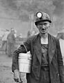
A coal miner in Wheelwright, Kentucky, 1946.
-
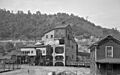
Coal mining has been a very important industry in Floyd County for a long time.


See also
 In Spanish: Condado de Floyd (Kentucky) para niños
