Wayland, Kentucky facts for kids
Quick facts for kids
Wayland, Kentucky
|
|
|---|---|

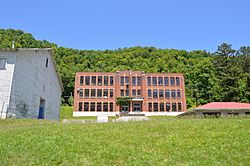
The former Wayland High School
|
|

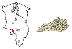
Location of Wayland in Floyd County, Kentucky.
|
|
| Country | United States |
| State | Kentucky |
| County | Floyd |
| Incorporated | 1923 |
| Government | |
| • Type | City Commission |
| Area | |
| • Total | 2.71 sq mi (7.02 km2) |
| • Land | 2.71 sq mi (7.01 km2) |
| • Water | 0.00 sq mi (0.00 km2) |
| Elevation | 1,161 ft (354 m) |
| Population
(2020)
|
|
| • Total | 389 |
| • Density | 143.65/sq mi (55.45/km2) |
| Time zone | UTC-5 (Eastern (EST)) |
| • Summer (DST) | UTC-4 (EDT) |
| ZIP code |
41666
|
| Area code(s) | 606 |
| FIPS code | 21-81012 |
| GNIS feature ID | 2405695 |
Wayland is a small city in Floyd County, Kentucky, United States. It is known as a "home rule-class city," which means it has the power to manage its own local affairs.
In 2010, about 426 people lived in Wayland. This was an increase from 298 people in 2000. By 2020, the population was 389.
Contents
History of Wayland
How Wayland Got Started
Wayland began as a coal mining town. In 1911, a company called Elk Horn Coal Company set up a coal camp here. This area was already known as "Martin's Mill." It was named after Rev. "Old" John Martin's Grist Mill, which had been there since before the Civil War.
During the Civil War, a Confederate general named Humphrey Marshall and his soldiers camped near the mill. They were on their way back to Virginia after a battle.
Naming the Town
From 1911 to 1914, the coal camp had different names, like "Camp Steele Creek" and "Watson Town." Later, it was officially named Wayland. This name honored Clarence Wayland Watson, who was the president of the Elk Horn Coal Company.
Growth and Challenges
The railroad arrived in Wayland in April 1914. A post office was opened on May 18 of the same year. The construction of the coal camp finished in the early 1920s. Wayland officially became a city in 1923.
On July 28, 2022, Wayland and many other places in eastern Kentucky faced severe flash flooding.
Wayland's Location
Wayland is located in the southwestern part of Floyd County. It sits in the valleys where Steele Creek flows into the Right Fork Beaver Creek.
Kentucky Route 7 runs through the city. This road goes north to Garrett, which is about 3.5 miles away. It also goes south to Topmost, about 9 miles away.
The United States Census Bureau says that Wayland covers about 2.71 square miles (7.02 square kilometers) of land. There is no water area within the city limits.
Education in Wayland
Students who live in Wayland attend public schools run by the Floyd County Schools system. Most students go to:
- Duff-Allen Central Elementary School
- Floyd Central High School
Population Changes
The population of Wayland has changed over the years. Here's a look at how many people have lived there during different census years:
| Historical population | |||
|---|---|---|---|
| Census | Pop. | %± | |
| 1920 | 1,862 | — | |
| 1930 | 2,436 | 30.8% | |
| 1940 | 2,888 | 18.6% | |
| 1950 | 1,807 | −37.4% | |
| 1960 | 1,340 | −25.8% | |
| 1970 | 384 | −71.3% | |
| 1980 | 601 | 56.5% | |
| 1990 | 359 | −40.3% | |
| 2000 | 298 | −17.0% | |
| 2010 | 426 | 43.0% | |
| 2020 | 389 | −8.7% | |
| U.S. Decennial Census | |||
In 2000, there were 298 people living in Wayland. There were 118 households, and 86 of these were families. The average household had about 2.53 people.
About 26.5% of the population was under 18 years old. Around 14.4% of the people were 65 years or older. The average age in Wayland was 35 years.
Images for kids
See also
 In Spanish: Wayland (Kentucky) para niños
 | Toni Morrison |
 | Barack Obama |
 | Martin Luther King Jr. |
 | Ralph Bunche |


