Martin, Kentucky facts for kids
Quick facts for kids
Martin, Kentucky
|
|
|---|---|

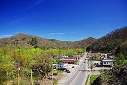
Main Street in Martin
|
|

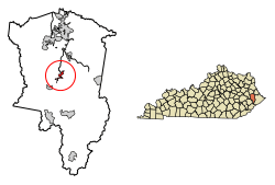
Location of Martin in Floyd County, Kentucky.
|
|
| Country | United States |
| State | Kentucky |
| County | Floyd |
| Incorporated | 1920 |
| Government | |
| • Type | Mayor-Council |
| Area | |
| • Total | 0.76 sq mi (1.95 km2) |
| • Land | 0.73 sq mi (1.90 km2) |
| • Water | 0.02 sq mi (0.06 km2) |
| Elevation | 656 ft (200 m) |
| Population
(2020)
|
|
| • Total | 513 |
| • Density | 700.82/sq mi (270.62/km2) |
| Time zone | UTC-5 (Eastern (EST)) |
| • Summer (DST) | UTC-4 (EDT) |
| ZIP code |
41649
|
| Area code(s) | 606 |
| FIPS code | 21-50286 |
| GNIS feature ID | 497596 |
Martin is a small city in Floyd County, Kentucky, in the United States. It is known as a "home rule-class city," which means it has the power to govern itself in many ways. In 2010, about 634 people lived there. By 2020, the population was 513.
History of Martin
Martin started as a place where people worked in coal mining in the early 1900s. The first post office opened in 1910. It was called "Bucks Branch" after a small stream nearby.
In 1913, the community changed its name to "Smalley." This new name honored Smalley Crisp, who owned land in the area. But by 1915, the community was renamed again. This time, it was called "Martin" after the postmaster, Martin Van Allen. The post office officially started using the name "Martin" in 1926.
Where is Martin?
Martin is located in the middle of Floyd County, Kentucky. Two main roads, Kentucky Route 80 and Kentucky Route 122, run along the west side of the city.
- KY 80 goes southwest about 41 miles to Hazard, Kentucky. It also goes north about 5 miles to U.S. Route 23, which is near Prestonsburg, Kentucky. Prestonsburg is the main town for the county.
- KY 122 goes northwest about 11 miles to Prestonsburg. It also goes south about 4 miles to Printer, Kentucky.
- Another road, Kentucky Route 1428, is called Main Street inside Martin. It connects Martin to Allen, Kentucky to the northeast.
The city of Martin covers about 0.76 square miles (1.95 square kilometers). A small part of this area, about 2.67%, is water. Beaver Creek, a stream that flows into the Levisa Fork river, runs through the center of Martin.
Martin's Population
Here's how Martin's population has changed over the years:
| Historical population | |||
|---|---|---|---|
| Census | Pop. | %± | |
| 1930 | 799 | — | |
| 1940 | 957 | 19.8% | |
| 1950 | 1,170 | 22.3% | |
| 1960 | 992 | −15.2% | |
| 1970 | 786 | −20.8% | |
| 1980 | 827 | 5.2% | |
| 1990 | 694 | −16.1% | |
| 2000 | 633 | −8.8% | |
| 2010 | 634 | 0.2% | |
| 2020 | 513 | −19.1% | |
| U.S. Decennial Census | |||
In 2000, there were 633 people living in Martin. Most of the people were White (97.31%). A small number were Native American, Asian, or Pacific Islander. About 0.95% of the population was Hispanic or Latino.
The people in Martin live in about 295 households. About 28.8% of these households had children under 18. The average household had about 2 people.
The population was spread out by age:
- 24.6% were under 18 years old.
- 8.2% were between 18 and 24 years old.
- 24.6% were between 25 and 44 years old.
- 25.8% were between 45 and 64 years old.
- 16.7% were 65 years or older.
The average age in Martin was 38 years old.
Schools in Martin
The public schools in Martin are managed by Floyd County Schools. The schools located in Martin are:
- May Valley Elementary School
- Renaissance Learning Center
See also
 In Spanish: Martin (Kentucky) para niños
 | Leon Lynch |
 | Milton P. Webster |
 | Ferdinand Smith |

