Bandy, Virginia facts for kids
Quick facts for kids
Bandy, Virginia
|
|
|---|---|

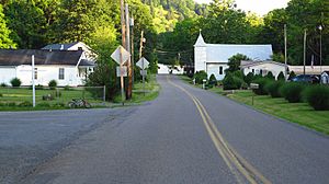
State Road 627 in Bandy
|
|
| Country | United States |
| State | Virginia |
| County | Tazewell |
| Elevation | 2,119 ft (646 m) |
| Time zone | UTC-5 (Eastern (EST)) |
| • Summer (DST) | UTC-4 (EDT) |
| ZIP code |
24602
|
| Area code(s) | 276 |
| GNIS feature ID | 1492508 |
Bandy is a small, unincorporated community located in Tazewell County, Virginia, in the United States. An "unincorporated community" means it's a place where people live, but it doesn't have its own separate local government like a town or city. Instead, it's usually managed by the county it's in.
Contents
Discovering Bandy, Virginia
Where is Bandy Located?
Bandy is nestled in the beautiful state of Virginia. You can find it about 3.4 miles (which is about 5.5 kilometers) northeast of a larger town called Richlands. It's situated right where two state roads, Route 624 and Route 627, meet. This makes it easy to find on a map!
Bandy is part of Tazewell County, which is in the southwestern part of Virginia. The area is known for its scenic landscapes and connection to the Appalachian Mountains.
How Bandy Got Its Name
Many places are named after important people or features. Bandy got its name from an early settler in the area. His name was William W. "Billy" Bandy. It's cool to think that a place can carry someone's name for so long!
What's in Bandy?
Even though Bandy is a small community, it plays an important role for the people who live there. It has its own post office with the ZIP code 24602. A post office is a vital part of any community, big or small, helping people send and receive mail.
 | DeHart Hubbard |
 | Wilma Rudolph |
 | Jesse Owens |
 | Jackie Joyner-Kersee |
 | Major Taylor |


