Belspring, Virginia facts for kids
Quick facts for kids
Belspring, Virginia
|
|
|---|---|
|
Census-designated place (CDP)
|
|

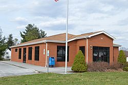
Post office
|
|
| Country | United States |
| State | Virginia |
| County | Pulaski |
| Area | |
| • Total | 3.6 sq mi (9.3 km2) |
| • Land | 3.6 sq mi (9.3 km2) |
| • Water | 0 sq mi (0 km2) |
| Elevation | 1,778 ft (542 m) |
| Population
(2000)
|
|
| • Total | 176 |
| • Density | 49/sq mi (19/km2) |
| Time zone | UTC-5 (EST) |
| • Summer (DST) | UTC-4 (EDT) |
| ZIP code |
24058 (Pulaski)
|
| Area code(s) | 540 |
| FIPS code | 51155 |
| GNIS feature ID | 1481619 |
Belspring is a small community in Pulaski County, Virginia, United States. It is known as a census-designated place (CDP). This means it is an area that looks like a town but does not have its own local government.
Belspring is located about 1,778 feet (542 m) above sea level. It uses the ZIP Code 24058 and the 540 for telephones. In 2010, the population of Belspring was 256 people.
About Belspring
Belspring is a quiet place found in the beautiful state of Virginia. It is part of Pulaski County, which is in the southwestern part of the state. The community is small, making it a peaceful area.
Location and Size
Belspring covers an area of about 3.6 square miles (9.3 square kilometers). All of this area is land, with no large bodies of water. Its location in Virginia makes it part of the Eastern Time Zone.
History and Landmarks
Even though Belspring is a small community, it has an important historical site. The John Hoge House is a special building in Belspring. It was added to the National Register of Historic Places in 1988. This means the house is recognized for its historical importance and is protected.
The National Register of Historic Places is a list of places in the United States that are important to American history. These places can be buildings, sites, structures, objects, or districts. Being on this list helps to preserve them for future generations.
See also
 In Spanish: Belspring (Virginia) para niños
 | William L. Dawson |
 | W. E. B. Du Bois |
 | Harry Belafonte |


