
Plymouth, North Carolina facts for kids
Quick facts for kids
Plymouth, North Carolina
|
||
|---|---|---|

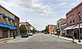
Downtown Plymouth
|
||
|
||

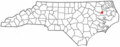
Location of Plymouth, North Carolina
|
||
| Country | United States | |
| State | North Carolina | |
| County | Washington | |
| Area | ||
| • Total | 4.03 sq mi (10.45 km2) | |
| • Land | 4.03 sq mi (10.44 km2) | |
| • Water | 0.01 sq mi (0.01 km2) | |
| Elevation | 13 ft (4 m) | |
| Population
(2020)
|
||
| • Total | 3,320 | |
| • Density | 824.03/sq mi (318.14/km2) | |
| Time zone | UTC-5 (Eastern (EST)) | |
| • Summer (DST) | UTC-4 (EDT) | |
| ZIP code |
27962
|
|
| Area code(s) | 252 | |
| FIPS code | 37-53040 | |
| GNIS feature ID | 2407138 | |

Plymouth is a town in Washington County, North Carolina, United States. It is the largest town in the county. In 2020, about 3,320 people lived there. Plymouth is the main town, also known as the county seat, of Washington County. It is located on the Roanoke River. The town is about seven miles (11 km) upriver from where the Roanoke River flows into the Albemarle Sound. This area is part of North Carolina's Inner Banks region.
Contents
Geography
Plymouth is a town with a total area of about 3.9 square miles (10.1 square kilometers). Most of this area is land. Only a very small part, about 0.26%, is water.
Climate
| Climate data for PLYMOUTH 5 E, NC, 1991-2020 normals | |||||||||||||
|---|---|---|---|---|---|---|---|---|---|---|---|---|---|
| Month | Jan | Feb | Mar | Apr | May | Jun | Jul | Aug | Sep | Oct | Nov | Dec | Year |
| Mean daily maximum °F (°C) | 53.9 (12.2) |
57.4 (14.1) |
64.2 (17.9) |
73.8 (23.2) |
80.2 (26.8) |
86.5 (30.3) |
89.3 (31.8) |
87.6 (30.9) |
82.7 (28.2) |
74.5 (23.6) |
64.3 (17.9) |
56.7 (13.7) |
72.6 (22.6) |
| Daily mean °F (°C) | 43.8 (6.6) |
46.3 (7.9) |
52.5 (11.4) |
61.6 (16.4) |
69.1 (20.6) |
76.5 (24.7) |
79.8 (26.6) |
78.3 (25.7) |
73.3 (22.9) |
63.5 (17.5) |
53.3 (11.8) |
46.7 (8.2) |
62.1 (16.7) |
| Mean daily minimum °F (°C) | 33.6 (0.9) |
35.2 (1.8) |
40.8 (4.9) |
49.4 (9.7) |
58.1 (14.5) |
66.4 (19.1) |
70.4 (21.3) |
69.0 (20.6) |
64.0 (17.8) |
52.6 (11.4) |
42.3 (5.7) |
36.7 (2.6) |
51.5 (10.8) |
| Average precipitation inches (mm) | 3.95 (100) |
3.40 (86) |
4.16 (106) |
3.74 (95) |
4.14 (105) |
5.42 (138) |
5.70 (145) |
6.60 (168) |
6.13 (156) |
4.14 (105) |
3.57 (91) |
3.64 (92) |
54.59 (1,387) |
| Average snowfall inches (cm) | 1.0 (2.5) |
0.3 (0.76) |
0.0 (0.0) |
0.0 (0.0) |
0.0 (0.0) |
0.0 (0.0) |
0.0 (0.0) |
0.0 (0.0) |
0.0 (0.0) |
0.0 (0.0) |
0.0 (0.0) |
0.1 (0.25) |
1.4 (3.6) |
| Average precipitation days (≥ 0.01 in) | 12.4 | 10.9 | 11.4 | 10.4 | 11.3 | 11.1 | 12.7 | 12.9 | 11.2 | 9.9 | 10.2 | 11.5 | 135.9 |
| Average snowy days (≥ 0.1 in) | 0.3 | 0.1 | 0.0 | 0.0 | 0.0 | 0.0 | 0.0 | 0.0 | 0.0 | 0.0 | 0.0 | 0.2 | 0.6 |
| Source: NOAA | |||||||||||||
Population Facts
| Historical population | |||
|---|---|---|---|
| Census | Pop. | %± | |
| 1850 | 951 | — | |
| 1860 | 872 | −8.3% | |
| 1870 | 1,389 | 59.3% | |
| 1880 | 836 | −39.8% | |
| 1890 | 1,212 | 45.0% | |
| 1900 | 1,011 | −16.6% | |
| 1910 | 2,165 | 114.1% | |
| 1920 | 1,847 | −14.7% | |
| 1930 | 2,139 | 15.8% | |
| 1940 | 2,461 | 15.1% | |
| 1950 | 4,486 | 82.3% | |
| 1960 | 4,666 | 4.0% | |
| 1970 | 4,774 | 2.3% | |
| 1980 | 4,571 | −4.3% | |
| 1990 | 4,328 | −5.3% | |
| 2000 | 4,107 | −5.1% | |
| 2010 | 3,878 | −5.6% | |
| 2020 | 3,320 | −14.4% | |
| U.S. Decennial Census | |||
How Many People Live Here?
In 2020, the 2020 United States census counted 3,320 people living in Plymouth. There were 1,522 households and 678 families.
| Race | Number | Percentage |
|---|---|---|
| White (non-Hispanic) | 887 | 26.72% |
| Black or African American (non-Hispanic) | 2,259 | 68.04% |
| Native American | 3 | 0.09% |
| Asian | 12 | 0.36% |
| Pacific Islander | 2 | 0.06% |
| Other/Mixed | 100 | 3.01% |
| Hispanic or Latino | 57 | 1.72% |
Population in 2010
Back in 2010, the 2010 United States Census showed that 3,878 people lived in Plymouth. Most of the people (68.3%) were Black. About 28.9% were White. Other groups included Native American, Asian, and people of two or more races. About 1.2% of the population was Hispanic or Latino.
History of Plymouth
Early Inhabitants
In 1585, the Moratuc tribe of American Indians lived in a large village near what is now Welch Creek. English settlers explored this area. "Moratuc" was the Indian name for the Roanoke River. The Moratuc tribe was likely an Algonquian tribe.
Founding the Town
Plymouth was started in 1787 by Arthur Rhodes. He divided 100 acres (0.4 square kilometers) of his land into 172 building lots. In 1790, the North Carolina General Assembly made Plymouth a "port of delivery." This meant ships could bring goods there. Later, in 1808, it became a "port of entry," allowing international trade.
The main government office, the county seat, of Washington County moved to Plymouth in 1823. A new courthouse was finished in 1824. This building stood until 1862. It burned down during the American Civil War from a shell fired by a Union gunboat.
Plymouth During the Civil War
Plymouth is famous for being the site of the second-largest battle in North Carolina during the American Civil War. It was also the last victory for the Confederate side. This was the Battle of Plymouth (1864).
A special Confederate ship, an ironclad warship called the CSS Albemarle, was very important in this battle. The ship was later sunk on October 27, 1864, while it was docked in Plymouth.

During the war, the Union forces controlled the Albemarle and Pamlico Sounds. Plymouth was important because it was at the mouth of the Roanoke River. The Union wanted to go up the river to capture the Wilmington and Weldon Railroad line in Weldon, North Carolina. This railroad was a key supply line for General Robert E. Lee's army in Virginia. Cutting off this line would have greatly weakened Lee's forces.
Upriver from Plymouth, at a place called Rainbow Branch, was Fort Branch. This fort successfully stopped Union gunboats and troops from sailing further upstream. The fort held out until April 10, 1865. This was just one day after General Lee surrendered at Appomattox Courthouse, Virginia. After Lee surrendered, the fort was abandoned, and its cannons were thrown into the Roanoke River. So, the histories of Fort Branch and Plymouth are closely linked.
Education and Landmarks
The Plymouth State Normal School was created to train African American teachers. In 1903, it moved to Elizabeth City and became Elizabeth City State University.
The Port O'Plymouth History Museum is located in the old train station downtown. It has a great collection of Civil War items. These include many belt buckles and buttons from the war. It also has a model of the ironclad ship, the CSS Albemarle.
Several historic buildings in Plymouth are listed on the National Register of Historic Places. These include the Garrett's Island House, Latham House, Perry-Spruill House, and the Washington County Courthouse. The New Chapel Missionary Baptist Church is also on this list.
Economy

The main industry in Plymouth is Domtar Paper Company, LLC.. This company makes paper. The paper mill has been the biggest employer in the area since 1937. It used to be owned by Weyerhauser, but Domtar bought its paper business in 2007.
In 2009, Domtar announced that it would stop making paper at the mill. Instead, the mill would produce only fluff pulp. This change meant that about a third of the workers, around 360 employees, would lose their jobs.
To help with job losses, the town is trying to become a place for tourists. Plymouth is surrounded by forests and swamps, which makes it a good spot for nature lovers. A boardwalk has been built along the river, offering nice views of the Roanoke River. Plymouth also hosts the North Carolina Black Bear Festival every year in early June. This three-day event celebrates bears.
Education
- Pines Elementary School
- Plymouth High School
- Pocosin Innovative Charter
- Washington County Middle School
- Washington County Early College High School
Notable People
- Aaron Anderson (1811–1886), a sailor who received a special honor.
- Charles Bowser (born 1959), a former player in the NFL (National Football League).
- Don Brown (born 1960), an author, lawyer, and former naval officer.
- Augustin Daly (1838–1899), a playwright, theater critic, and manager.
- Louis C. Latham (1840–1895), who was a member of the United States House of Representatives.
- Jacklyn H. Lucas (1928–2008), a marine and recipient of the Medal of Honor.
- Lowes Moore (born 1957), a basketball player.
- Rodney Purvis (born 1994), a basketball player.
- Reddy Rowe (1887–1966), a football and baseball player and coach.
- J. B. Smoove (born 1965), an actor and comedian.
- Frederick W. Wurster (1850–1917), who was the Mayor of Brooklyn from 1896 to 1897.
Images for kids
-
Downtown Plymouth
-
Location of Plymouth, North Carolina
-
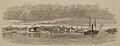
Plymouth in 1864
-
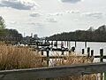
The Roanoke River in Plymouth. The Domtar facility is in the background.
See also
 In Spanish: Plymouth (Carolina del Norte) para niños
