Conway, North Carolina facts for kids
Quick facts for kids
Conway, North Carolina
|
|
|---|---|

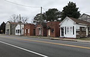
Commercial buildings on South Church Street
|
|

Location of Conway, North Carolina
|
|
| Country | United States |
| State | North Carolina |
| County | Northampton |
| Area | |
| • Total | 1.82 sq mi (4.72 km2) |
| • Land | 1.82 sq mi (4.72 km2) |
| • Water | 0.00 sq mi (0.00 km2) |
| Elevation | 102 ft (31 m) |
| Population
(2020)
|
|
| • Total | 752 |
| • Density | 412.28/sq mi (159.21/km2) |
| Time zone | UTC-5 (Eastern (EST)) |
| • Summer (DST) | UTC-4 (EDT) |
| ZIP code |
27820
|
| Area code(s) | 252 |
| FIPS code | 37-14400 |
| GNIS feature ID | 2406307 |
Conway is a small town located in Northampton County, North Carolina, in the United States. It's a friendly place where people live and work. In 2010, about 836 people called Conway home. It is also part of the larger Roanoke Rapids area, which helps connect it to nearby communities.
Contents
Where is Conway Located?
Conway is found in the eastern part of North Carolina. It covers an area of about 1.8 square miles (4.7 square kilometers). This means it's a fairly small and cozy town. All of Conway's area is land, so there are no big lakes or rivers within its borders.
Who Lives in Conway?
Conway has seen its population change over the years. In 2020, there were 752 people living here. This number helps us understand how many people call Conway home.
Conway's Population Over Time
| Historical population | |||
|---|---|---|---|
| Census | Pop. | %± | |
| 1920 | 294 | — | |
| 1930 | 400 | 36.1% | |
| 1940 | 449 | 12.3% | |
| 1950 | 618 | 37.6% | |
| 1960 | 662 | 7.1% | |
| 1970 | 694 | 4.8% | |
| 1980 | 678 | −2.3% | |
| 1990 | 759 | 11.9% | |
| 2000 | 734 | −3.3% | |
| 2010 | 836 | 13.9% | |
| 2020 | 752 | −10.0% | |
| U.S. Decennial Census | |||
A Look at Conway's Community
In 2020, there were 752 people living in Conway. These people made up 306 households and 221 families. The community is made up of people from different backgrounds. About 49% of the residents were White, and about 45% were Black or African American. A smaller number of people were Native American, Asian, or from other backgrounds. About 2% of the people identified as Hispanic or Latino. This mix of people makes Conway a diverse place to live.
Famous People From Conway
Some talented people have grown up in Conway and gone on to achieve great things.
Sports Stars from Conway
- Stu Flythe: He was a professional baseball player. Stu played in MLB, which is the highest level of baseball in the United States.
- Fred Vinson: Fred is a former professional basketball player. He played in the NBA, which is the top basketball league. Today, he is a coach, helping new players learn the game.
See also
 In Spanish: Conway (Carolina del Norte) para niños
 | Delilah Pierce |
 | Gordon Parks |
 | Augusta Savage |
 | Charles Ethan Porter |

