Murfreesboro, North Carolina facts for kids
Quick facts for kids
Murfreesboro, North Carolina
|
|
|---|---|

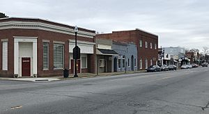
East Main Street
|
|

Location of Murfreesboro, North Carolina
|
|
| Country | United States |
| State | North Carolina |
| County | Hertford |
| Area | |
| • Total | 2.32 sq mi (6.01 km2) |
| • Land | 2.27 sq mi (5.88 km2) |
| • Water | 0.05 sq mi (0.13 km2) |
| Elevation | 79 ft (24 m) |
| Population
(2020)
|
|
| • Total | 2,619 |
| • Density | 1,153.74/sq mi (445.48/km2) |
| Time zone | UTC-5 (Eastern (EST)) |
| • Summer (DST) | UTC-4 (EDT) |
| ZIP code |
27855
|
| Area code(s) | 252 |
| FIPS code | 37-45640 |
| GNIS feature ID | 2406219 |
Murfreesboro is a town in Hertford County, North Carolina, United States. In 2020, about 2,619 people lived there. The town is also home to Chowan University.
Contents
Exploring Murfreesboro's Location and Size
Murfreesboro is in the northwestern part of Hertford County. It sits on high ground south of the Meherrin River.
Roads and Travel
U.S. Route 258 goes through the eastern side of town. U.S. Route 158 goes around the town to the south. US-258 leads southwest about 51 miles (82 km) to Tarboro. It goes northeast about 21 miles (34 km) to Franklin, Virginia. US-158 leads east about 10 miles (16 km) to Winton, which is the county seat. It goes west about 37 miles (60 km) to Roanoke Rapids.
Land and Water Area
The town covers a total area of about 2.3 square miles (6.0 sq km). Most of this area, about 2.27 square miles (5.88 sq km), is land. A small part, about 0.05 square miles (0.13 sq km), is water.
Murfreesboro's Climate and Weather
Murfreesboro has a humid subtropical climate. This means it has hot, humid summers and mild winters. The average high temperature in July is about 87.7°F (30.9°C). The average low temperature in January is about 28.7°F (-1.8°C). The town gets about 49.6 inches (1,260 mm) of rain each year. Snowfall is rare, with an average of about 2.6 inches (6.6 cm) per year.
People Living in Murfreesboro
| Historical population | |||
|---|---|---|---|
| Census | Pop. | %± | |
| 1860 | 466 | — | |
| 1870 | 753 | 61.6% | |
| 1880 | 645 | −14.3% | |
| 1890 | 674 | 4.5% | |
| 1900 | 657 | −2.5% | |
| 1910 | 809 | 23.1% | |
| 1920 | 621 | −23.2% | |
| 1930 | 1,000 | 61.0% | |
| 1940 | 1,550 | 55.0% | |
| 1950 | 2,140 | 38.1% | |
| 1960 | 2,643 | 23.5% | |
| 1970 | 4,418 | 67.2% | |
| 1980 | 3,007 | −31.9% | |
| 1990 | 2,580 | −14.2% | |
| 2000 | 2,045 | −20.7% | |
| 2010 | 2,835 | 38.6% | |
| 2020 | 2,619 | −7.6% | |
| U.S. Decennial Census | |||
In 2020, there were 2,619 people living in Murfreesboro. There were 1,081 households and 552 families. About 51.39% of the people were Black or African American. About 35.85% were White. About 8.32% were Hispanic or Latino.
Murfreesboro's Past: A Look at History
Murfreesboro has a rich history, from its first inhabitants to its role in important events.
Early Inhabitants and European Visits
The first people known to live in this area were Native Americans. These included the Nottoway, Meherrin, and Chowanoke tribes.
The first European to visit was likely John White from the Roanoke Colony in the 1500s. An expedition from Jamestown, Virginia, also visited in the 1600s. The last native people, the Chowanoke, were moved to a reservation after conflicts with the English in the late 1600s.
From Colonial Times to the American Revolution
The first land record in the area is from 1714. It was a grant to Henry Wheeler for land on the Meherrin River. In 1735, Joseph Parker started the Meherrin Church. This was the second-oldest Baptist church in North Carolina.
In 1746, William Murfree, an Irish immigrant, bought land on the Meherrin River. This area became known as Murfree's Landing. In 1754, it was named a King's Landing. This meant imports and exports were checked there by a King's representative.
Revolutionary War and Growth

During the American Revolutionary War, in 1781, British forces attacked near Murfree's Landing. Hardy Murfree, William Murfree's son, led a local group that fought back.
In 1787, William Murfree gave 97 acres (39 ha) of land to help the settlement grow into a town. The town was officially named Murfreesboro on January 6, 1787. This also created a public dock, as the town was at the farthest point ships could travel on the Meherrin River.
In 1790, the U.S. Congress made Murfreesboro an official port of entry. This meant it was an important place for trade. Records show profitable trade with New England and the West Indies.
Education and Important Events in the 1800s
In 1809, the Hertford Academy was started in Murfreesboro for boys. Later, in 1814, Harriet and Martha Sketchly helped expand the school for girls. By 1849, it became the Chowan Baptist Female Institute. This school is now Chowan University.
In 1831, Murfreesboro sent armed forces to help stop Nat Turner's slave rebellion in Virginia. After this event, laws were changed in Virginia and North Carolina. These laws limited the rights of free Black people and stopped the education of both free Black people and enslaved people.
Learning in Murfreesboro
Murfreesboro has schools for younger students and a university.
Local Schools
Children in Murfreesboro attend Riverview Elementary School and Hertford County Middle School. Both are part of the Hertford County Public Schools system.
Chowan University
Chowan University, a small Baptist university, is located right in Murfreesboro. It offers many different study programs.
Business and Trade in Murfreesboro
Murfreesboro is no longer a busy port. The last commercial ship stopped service to the town in 1966. The town is served by the Roanoke-Chowan News-Herald newspaper. This newspaper is based in nearby Ahoskie.
Fun Places to Visit in Murfreesboro
Murfreesboro has many historic buildings and interesting places to explore.
Historic Buildings and Sites
Many grand houses and other buildings in Murfreesboro are on the National Register of Historic Places. These include the David A. Barnes House, The Cedars, The Columns, Cowper-Thompson House, Freeman House, Melrose, Myrick House, Myrick-Yeates-Vaughan House, Francis Parker House, William Rea Store, Roberts-Vaughan House, and John Wheeler House. The Princeton Site and the Murfreesboro Historic District are also listed.
The John Wheeler House is known as the birthplace of John Hill Wheeler. He was a politician who served as a diplomat to Nicaragua. It was discovered that Hannah Bond, an enslaved woman who later wrote The Bondwoman's Narrative, was held by him. She escaped around 1857. Her book was published in 2002 and is thought to be the first novel by an African-American woman.
Brady C. Jefcoat Museum
The old Murfreesboro public school building is now the Brady C. Jefcoat Museum. This museum has a large collection of everyday items from the late 1800s and early 1900s. You can see old phonographs, radios, washing machines, and farm tools. It's like stepping back in time!
Famous People from Murfreesboro
Many notable people have connections to Murfreesboro:
- William Hill Brown: An author who wrote the first American novel.
- Tim Cofield: A former professional football player in the NFL and CFL.
- Sallie Southall Cotten: A writer and clubwoman.
- Curtis Deloatch: A former cornerback in the NFL.
- Khalid Sheikh Mohammed: Attended Chowan University in 1983.
- Hardy Murfree: A military leader from North Carolina during the American Revolutionary War.
- Julian Myrick: An insurance salesman and promoter of tennis.
- William N. H. Smith: A Democratic congressman and North Carolina Supreme Court justice.
- Dwight Stephenson: A famous football player in the NFL. He is in the Pro Football Hall of Fame.
- Fred Vinson: A former NBA player and current coach.
- John H. Wheeler: The first United States ambassador to Nicaragua.
See also
 In Spanish: Murfreesboro (Carolina del Norte) para niños
 | Precious Adams |
 | Lauren Anderson |
 | Janet Collins |

