
Chesapeake, Virginia facts for kids
Quick facts for kids
Chesapeake, Virginia
|
|||||
|---|---|---|---|---|---|

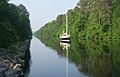
Great Dismal Swamp Canal
|
|||||
|
|||||
| Motto(s):
"One Increasing Purpose"
|
|||||

Chesapeake, Virginia
Location in Virginia

Chesapeake, Virginia
Location in the United States
|
|||||
| Country | |||||
| State | |||||
| Founded | 1963 (1919 as South Norfolk, 1634 as Norfolk County, Virginia) | ||||
| Government | |||||
| • Type | Mayor–council–manager | ||||
| Area | |||||
| • Independent city | 350.95 sq mi (908.95 km2) | ||||
| • Land | 338.51 sq mi (876.74 km2) | ||||
| • Water | 12.44 sq mi (32.21auto279.26 km2) 2.9% | ||||
| Population
(2020)
|
|||||
| • Independent city | 249,422 | ||||
| • Rank | 90th in the United States 2nd in Virginia |
||||
| • Density | 710.705/sq mi (274.4067/km2) | ||||
| • Metro | 1,799,674 | ||||
| Time zone | UTC−5 (EST) | ||||
| • Summer (DST) | UTC−4 (EDT) | ||||
| ZIP codes |
23320-23328
|
||||
| Area code(s) | 757 and 948 | ||||
| FIPS code | 51-16000 | ||||
| GNIS feature ID | 1496841 | ||||
| Website | www.cityofchesapeake.net | ||||


Chesapeake is a large city in Virginia, United States. It is called an independent city because it is not part of any county. In 2020, about 249,422 people lived there. This makes it the second-largest city in Virginia.
Chesapeake is part of the Hampton Roads area, which is a group of cities around a large harbor. The city was formed in 1963. This happened when the city of South Norfolk joined with parts of Norfolk County. Chesapeake is one of the largest cities in Virginia by land area. It is also the 17th largest in the entire United States.
Chesapeake is a very diverse city. It has some busy city areas. But it also has many miles of farms, forests, and wetlands. A big part of the Great Dismal Swamp National Wildlife Refuge is located here. The city stretches from the border of North Carolina to the Hampton Roads harbor. It is also along the Atlantic Intracoastal Waterway. In 2011, Bloomberg Businessweek magazine called Chesapeake the 21st best city in the U.S.
Contents
History of Chesapeake

The city of Chesapeake was created in 1963. This happened when the old city of South Norfolk joined with Norfolk County. People in both areas voted to make this change. The new name, Chesapeake, was also chosen by voters.
Norfolk County was formed way back in 1691. It used to include areas that are now the cities of Norfolk and Portsmouth. Over time, these cities grew and took over parts of the county. By becoming an independent city, Chesapeake could keep its borders stable. Cities could not take land from other cities.
South Norfolk became a town in 1919 and then an independent city in 1922. Its residents wanted to be more equal with the bigger cities nearby. The joining of South Norfolk and Norfolk County was part of a trend. Many local governments in southeastern Virginia changed between 1952 and 1975.
The Chesapeake area was one of the first places settled in colonial Virginia. The Intracoastal Waterway runs through Chesapeake. Here, the Great Bridge locks connect two important canals. This spot was also where the Battle of Great Bridge happened on December 9, 1775. This battle was important in the early days of the American Revolutionary War. It led to the British leaving Virginia.

For a long time, Chesapeake was mostly a suburban or rural area. People often lived there and traveled to work in nearby cities like Norfolk and Virginia Beach. But starting in the late 1980s and 1990s, Chesapeake grew a lot. Many new businesses and industries moved there. This fast growth caused some challenges for the city. For example, roads became crowded and schools got full.
Geography of Chesapeake
Chesapeake is located at 36°46′2″N 76°17′14″W / 36.76722°N 76.28722°W. The city covers about 351 square miles (909 square kilometers). Most of this area is land, with about 10 square miles (26 square kilometers) being water. A large part of the Great Dismal Swamp is found in Chesapeake.
Diverse Environment in Chesapeake
Chesapeake is one of the largest cities in Virginia by land area. This means city leaders have to work hard to provide services across a wide space. The city has many different communities, each with its own history. Leaders must balance building new homes and businesses with protecting forests and wetlands. A big part of the Great Dismal Swamp is within the city limits.
Neighboring Areas
Chesapeake shares borders with several other cities and counties:
- Portsmouth, Virginia (to the north)
- Norfolk, Virginia (to the north)
- Virginia Beach, Virginia (to the east)
- Currituck County, North Carolina (to the south)
- Camden County, North Carolina (to the south)
- Suffolk, Virginia (to the west)
Chesapeake Communities
Chesapeake is divided into six main areas called boroughs. These are South Norfolk, Pleasant Grove, Butts Road, Deep Creek, Washington, and Western Branch.
Many smaller communities have also grown within these boroughs. Some of these include:
- Benefit
- Bower's Hill
- Camelot
- Crestwood
- Deep Creek
- Fentress
- Gilmerton
- Grassfield
- Great Bridge
- Greenbrier
- Hickory
- Indian River
- Mount Pleasant
- Oak Grove
- Portlock
- South Norfolk
- Wallaceton
Chesapeake Climate
Chesapeake has a climate with hot, humid summers. Winters are usually mild to cool. This type of weather is called a humid subtropical climate.
Chesapeake Population Facts
| Historical population | |||
|---|---|---|---|
| Census | Pop. | %± | |
| 1970 | 89,580 | — | |
| 1980 | 114,486 | 27.8% | |
| 1990 | 151,976 | 32.7% | |
| 2000 | 199,184 | 31.1% | |
| 2010 | 222,209 | 11.6% | |
| 2020 | 249,422 | 12.2% | |
| U.S. Decennial Census | |||

In 2020, Chesapeake had a population of 249,422 people. The city is home to many different groups of people. About 54.4% of the population was White. About 28.4% was Black or African American. About 3.6% was Asian. And about 7.2% of the population was Hispanic or Latino.
In 2010, there were about 69,900 households in Chesapeake. About 41% of these households had children under 18 living there. The average household had about 2.79 people. The average family had about 3.17 people. The median age in the city was 35 years old. This means half the people were older than 35 and half were younger.
Economy and Jobs in Chesapeake
Chesapeake has many different types of jobs. The city is home to the international headquarters of Dollar Tree, a well-known store.
Top Employers in Chesapeake
Many large organizations and companies provide jobs in Chesapeake. Here are some of the biggest employers:
| # | Employer | Number of Employees |
|---|---|---|
| 1 | Chesapeake City Public Schools | 6,248 |
| 2 | City of Chesapeake | 3,927 |
| 3 | Chesapeake Regional Medical Center | 2,038 |
| 4 | Walmart | 1,783 |
| 5 | Dollar Tree | 1,292 |
| 6 | Sentara Healthcare | 1,478 |
| 7 | Cox Communications | 1,137 |
| 8 | Tidewater Staffing | 1,259 |
| 9 | Capital One Services LLC | 827 |
| 10 | QVC | 1,037 |
Military Presence in Chesapeake
Chesapeake is home to two important Navy bases:
- Northwest Annex, located in the Hickory area.
- NALF Fentress, which is an airfield.
Fun Places to Visit in Chesapeake
- Chesapeake Arboretum: A beautiful place to see different trees and plants.
- Chesapeake and Albemarle Canal: A historic waterway.
- Dismal Swamp Canal: Another historic canal, great for boating and nature.
Media and News in Chesapeake
Chesapeake has its own daily newspaper called The Virginian-Pilot. Other local papers include the Port Folio Weekly. You can also find regional magazines like Hampton Roads Magazine.
The city is served by many radio stations. There are also several television stations. Major TV channels include WTKR-TV (CBS), WAVY (NBC), and WVEC-TV (ABC). Cox Communications also provides a local 24-hour news channel called LNC 5.
Education in Chesapeake
Chesapeake City Public Schools is the local school district. It manages all the public schools in the city.
The Chesapeake Public Library System has seven branches and a lending kiosk. You can get a library card and borrow books or other items. They also offer many online resources. The library helps students and adults with their education and career goals. They have free online classes and career help events.
Getting Around Chesapeake
Roads and Bridges in Chesapeake

Some roads in Chesapeake have tolls, meaning you have to pay to use them. These include the Chesapeake Expressway, Veterans Bridge, and the Jordan Bridge.
Major highways like Interstate 64 and U.S. Highway 17 pass through Chesapeake. The city also has its own special bridge division. This team of workers maintains 90 bridges and overpasses. Five of these are drawbridges that open for boats about 30,000 times a year.
Airports Near Chesapeake
For commercial flights, people in Chesapeake use Norfolk International Airport. It is located in the nearby city of Norfolk.
Within Chesapeake, there are two smaller airports. Chesapeake Regional Airport is for private planes. Hampton Roads Executive Airport is also for private airplane owners. The U.S. Navy also has an airfield here called NALF Fentress.
Waterways and Ports in Chesapeake
The Intracoastal Waterway goes through Chesapeake. The city also has many port facilities along the Western and Southern Branches of the Elizabeth River.
The Dismal Swamp Canal also runs through Chesapeake. This canal was surveyed by George Washington himself! It is the oldest man-made canal in the United States that is still used today. It has been open for over 230 years. The canal starts in the Deep Creek area and goes into North Carolina.
Trains in Chesapeake
Five railroad lines pass through Chesapeake. They help move goods to and from the port facilities. The two main railroads are CSX Transportation and Norfolk Southern.
There are also plans to bring high-speed passenger train service to Chesapeake. This would connect the city to Richmond and other areas.
Bus Services in Chesapeake
Hampton Roads Transit buses serve Chesapeake. They also connect to other cities in the Hampton Roads Area.
Utilities in Chesapeake
The city's Department of Utilities provides water and sewer services. Chesapeake gets its electricity from Dominion Virginia Power. This company has power plants in the area. Virginia Natural Gas provides natural gas to the city.
Chesapeake gets most of its water from the Northwest River. Because the river water can sometimes be salty, the city uses a special system called reverse osmosis to clean it. Additional freshwater for the area comes from Lake Gaston, which is about 80 miles (129 kilometers) away. A large pipeline brings this water to Chesapeake.
Famous People from Chesapeake
- Eddie Butler, professional baseball player
- Clarence Clemons, musician
- Michael Cuddyer, professional baseball player
- Kenny Easley, NFL Hall of Fame member
- Randy Forbes, former U.S. Representative
- DeAngelo Hall, professional football player
- Percy Harvin, professional football player
- Frank Hassell (born 1988), basketball player
- Grant Holloway, 110 m hurdle world champion
- Patrick Jones II, professional football player
- Nick Leitz NASCAR driver
- Ashton Lewis Jr. NASCAR driver
- Mizkif, Twitch streamer
- Alonzo Mourning, professional basketball player
- Omos, professional wrestler for WWE
- Darren Perry, professional NFL football player and coach
- Jay Pharoah, comedian
- Chris Richardson, singer
- Ricky Rudd, NASCAR driver
- Mike Scott, professional basketball player
- Don Shipley, retired Navy Seal and YouTube star
- Scott Sizemore, professional baseball player
- Ben Smith, 2015 CrossFit games champion
- Cam Thomas, professional basketball player
- Darryl Tapp, professional football player
- Justin Upton, professional baseball player
- Melvin Upton Jr., professional baseball player
- Brianté Weber (born 1992), basketball player
- David Wright, professional baseball player
Images for kids
-
Great Dismal Swamp Canal
See also
 In Spanish: Chesapeake (Virginia) para niños
