
Mississippi–Alabama barrier islands facts for kids

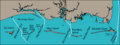
The Mississippi–Alabama barrier islands and associated tidal inlets in 2007. Before 2019 Ship Island was divided into two smaller islands.
|
|

Mississippi–Alabama barrier islands
Location in Mississippi
|
|
| Geography | |
|---|---|
| Location | Gulf of Mexico |
| Coordinates | 30°13′30″N 88°36′00″W / 30.225°N 88.600°W |
| Total islands | 5 |
| Major islands | Cat Island, Ship Island, Horn Island, Petit Bois Island, Dauphin Island |
| Length | 70 mi (110 km) |
| Administration | |
| States | Mississippi, Alabama |
The Mississippi–Alabama barrier islands are a group of five long, thin islands in the Gulf of Mexico. They stretch along the coasts of Mississippi and Alabama. These islands act like a natural wall, protecting the quiet waters of the Mississippi Sound from the bigger waves of the Gulf.
The main islands are Cat Island, Ship Island, Horn Island, Petit Bois Island, and Dauphin Island. Big gaps, called inlets, separate the islands. Some of these inlets have been made deeper for shipping channels, allowing large ships to reach ports along the coast.
The islands have changed a lot since the 1800s. They have generally gotten smaller and moved westward. This happens especially after strong storms like tropical cyclones. Most of these islands do not have people living on them. A large part of the Mississippi islands is protected as part of the Gulf Islands National Seashore.
Contents
Island Geography
The Mississippi–Alabama barrier islands are located about 10 to 14 miles (16 to 23 km) away from the Mississippi Gulf Coast. They run parallel to the coast for about 70 miles (110 km). This chain of islands stretches from the Bay of St. Louis to Mobile Bay. They separate the Mississippi Sound from the main Gulf of Mexico.
The five main islands are:
- Cat Island
- Ship Island (both in Harrison County, Mississippi)
- Horn Island
- Petit Bois Island (both in Jackson County, Mississippi)
- Dauphin Island (in Mobile County, Alabama)
The only place with a significant number of people is the town of Dauphin Island, Alabama. It is on the eastern half of Dauphin Island. The other islands are mostly empty. Parts of the four Mississippi islands have been part of the Gulf Islands National Seashore since 1971.
Island Features
The islands have sandy beaches on both sides. The beaches facing the Gulf of Mexico are wider. They also have finer sand because the waves there are stronger. The middle parts of the islands have flat sandy areas, coastal marshes (wetlands), and areas with sand dunes. They also have ponds with salty water.
Wide gaps separate the islands. These gaps are called inlets. Some inlets are made deeper by regularly removing sand, a process called dredging. This creates deep shipping channels for large ships.
- Ship Island Pass (between Cat Island and Ship Island) is used for ships going to Gulfport, Mississippi.
- Dog Keys Pass (between Ship Island and Horn Island) is for ships going to Biloxi, Mississippi.
- Horn Island Pass (between Horn Island and Petit Bois Island) is for ships going to Pascagoula, Mississippi.
- Petit Bois Pass (between Petit Bois Island and Dauphin Island) is not a deep shipping channel.
- The mouth of Mobile Bay, east of Dauphin Island, has a channel for ships going to Mobile, Alabama.
How the Islands Change Over Time
The barrier islands are the parts of a long sand bar that stick out of the water. This sand bar runs along the entire Mississippi Sound. Scientists believe it started forming around 2500 BCE. This was when the Gulf's average sea level dropped.
The sand on the islands is mostly white quartz. It has a medium grain size. The shapes and sizes of the islands have changed a lot since the 1800s. The islands are generally shrinking and moving westward. This movement is caused by the main ocean current that pushes sand along the coast.
This current brings sand to the islands from the east. However, in recent centuries, the islands have lost more sand than they have gained. This might be because the longshore current has become weaker. Also, man-made shipping channels can trap sand. This means less sand reaches the islands. This unbalance between sand being lost and sand being added causes the island shorelines to slowly move back.
Impact of Storms and Sea Level
Big tropical cyclones (like hurricanes) regularly change the islands' shapes. They do this with strong winds, waves, and storm surges (rising water). Even though severe storms can quickly change the islands' look and natural environments, the plants and land usually recover over a few years.
The slow rise in sea level in the Gulf over the last century has also made the islands smaller. However, this effect is not as big as the impact of removing sand from the system by dredging shipping channels.
Island Life: Plants and Animals
The inner parts of the islands have lots of plants. There are pine forests on the higher parts. In the lower, wet areas, there are marsh plants.
Larger islands are home to land animals like raccoons and wild pigs. There are also animals that live in both water and on land, like nutria. Birds like osprey live there all year. Many other birds visit during their migrations. The sandy beaches of the islands are important nesting spots for Atlantic ridley sea turtles.
Along the north side of the islands, there are large areas of seagrass meadows. These include different types of seagrass like turtle grass, manatee grass, shoal grass, star grass, and wigeon grass. These seagrass beds provide food and homes for many water animals. This includes penaeid shrimp, blue crab, spotted seatrout, and other shellfish and fish.
The Five Islands
Cat Island

Cat Island is about 3.5 miles (5.6 km) long. It is at the western end of the Mississippi Sound, south of Gulfport. This island has stayed pretty much the same shape since people started mapping it. This is partly because its middle part is quite high. It has a T-shape, with sand spits reaching north and south from its eastern end. The southern spit has lost more sand than the northern one. All parts of the island have become narrower over time.
Ship Island

Ship Island is about 7 miles (11 km) long. It is in the western part of the Mississippi Sound, south of Biloxi. This island has changed a lot over the last 200 years. Its eastern spit has quickly moved back due to erosion. The narrow middle part of the island has shifted closer to the mainland. Strong storms have broken through the middle of the island many times. The most recent time was during Hurricane Camille in 1969. The gap created, called the "Camille Cut," was filled in by the United States Army Corps of Engineers in 2019.
Horn Island

Horn Island is about 13 miles (21 km) long. It is in the central part of the Mississippi Sound. Since maps were first made, the east end of the island has shrunk due to erosion. However, its west end has grown longer because sand has built up there. The east end has lost more land than the west end has gained. The island has also generally become narrower.
Petit Bois Island

Petit Bois Island is about 6 miles (9.7 km) long. It is in the eastern part of the Mississippi Sound, south of Pascagoula. This island has changed its shape more dramatically than any other island in the chain over the past 200 years. The wider, triangle-shaped part that is now the island's eastern end was its far western end as recently as the 1840s. Like Horn Island, its eastern spit has moved back quickly. A new western tail has grown more slowly.
Dauphin Island

Dauphin Island has over 1,200 people living on it. It is about 15 miles (24 km) long. It sits at the east end of the Mississippi Sound and marks the western edge of the mouth of Mobile Bay. The eastern quarter of the island is wider and higher. The western end is narrow and more easily changed by storms. The town of Dauphin Island is on the east end. The long western tail has generally gotten longer. This is because sand is deposited there by the longshore drift. It has also shifted toward the mainland. This is due to erosion on the Gulf side and water washing over it during big storms.
Images for kids
-
The Mississippi–Alabama barrier islands and associated tidal inlets in 2007. Before 2019 Ship Island was divided into two smaller islands.
