
Ship Island facts for kids

Aerial view of previously divided Ship Island, looking east (with West Ship Island in foreground)
|
|

Historical map of the changing geomorphology of Ship Island
|
|

Ship Island
Location in Mississippi
|
|
| Geography | |
|---|---|
| Location | Gulf of Mexico |
| Coordinates | 30°13′N 88°55′W / 30.217°N 88.917°W |
| Archipelago | Mississippi–Alabama barrier islands |
| Administration | |
| State | Mississippi |
| County | Harrison County |
Ship Island is a long, thin island off the coast of Mississippi in the Gulf of Mexico. It's one of several barrier islands that protect the mainland from ocean storms. In 1969, a huge storm called Hurricane Camille actually split the island into two parts: West Ship Island and East Ship Island.
But don't worry, the island is now whole again! In 2019, engineers finished a big project to connect the two parts back together. Ship Island is also home to Fort Massachusetts, a historic fort built a long time ago. Part of the island is protected as part of the Gulf Islands National Seashore, a special park.
Contents
Discovering Ship Island's Past

Ship Island has a very interesting history. It has the only deep-water harbor between Mobile Bay and the Mississippi River. This made it a very important stop for ships carrying explorers, settlers, and soldiers. Many different flags have flown over Ship Island, including those of France, Spain, Britain, and the United States.
Early Explorers and Settlers
A French explorer named Pierre Le Moyne d'Iberville first mapped Ship Island on February 10, 1699. He used the island as a base to explore the Mississippi River. For a while, the island was a main entry point for French people moving to the New World. Sadly, some immigrants died after arriving at Ship Island.
In 1702, the French named the island Ile aux Vaisseaux, which means "Ship Island." This was because its deep water was a safe place for ships to anchor. After the city of New Orleans was founded in 1718, Ship Island continued to be a main port for French settlers from 1720 to 1724.
Changing Hands: A Story of Ownership
The island's ownership changed many times. In 1763, after the Seven Years' War, France gave the island to Great Britain. Then, in 1783, at the end of the American Revolution, Great Britain gave it to Spain.
The United States claimed the island in 1810 as part of the Louisiana Purchase.
Ship Island in Wars
During the War of 1812, a British fleet with 10,000 soldiers used Ship Island as a starting point. They were preparing for the Battle of New Orleans.
Later, in 1849, the U.S. Navy anchored at Ship Island. They wanted to stop groups of armed adventurers from using nearby islands to plan attacks on Cuba.
Building Fort Massachusetts
In 1858, the state of Mississippi gave control of the island to the United States government. A plan was made to build strong forts along the Atlantic and Gulf coasts, including Ship Island. Construction of a fort on the island began in 1859.
During the American Civil War, the fort was not yet finished. Confederate soldiers called it Fort Twiggs. The island later became a prison for Confederate soldiers. It was also a base for a unit of African-American soldiers called the Louisiana Native Guards.
In 1861, there was a short cannon fight between Confederates at Fort Twiggs and a Union warship. In 1862, the Union took control of the fort and renamed it Fort Massachusetts. Construction on the fort stopped in 1866, and it was never fully completed.
Lighthouses and Quarantines

The island's first lighthouse was built in 1853. It was made of brick. In 1880, Ship Island became the country's first quarantine station. This meant ships with sick people had to stop there before going to the mainland. The fort closed in 1903.
In 1886, a new wooden lighthouse was built to replace the old brick one, which had been damaged by waves.
Ship Island in Modern Times
During World War II, the Coast Guard used the island to patrol for enemy submarines. Later, the island's old quarantine station was used as a place for military members to relax.
In 1969, Hurricane Camille hit the island with a huge 30-foot (9.1 m) tidal surge. This powerful storm cut Ship Island into two separate islands, East Ship Island and West Ship Island. The gap was called the Camille Cut.

In 1972, the wooden lighthouse from 1886 accidentally burned down because of campers. In 1999, a new lighthouse was built to look like the old 1886 one.
In 2005, Hurricane Katrina caused a lot of damage. East Ship Island was almost completely covered by water. West Ship Island lost its visitor center, restrooms, and pier. Fort Massachusetts, however, was not badly damaged and reopened quickly. The pier and boardwalk were rebuilt. The new lighthouse was destroyed.
After Hurricane Katrina, the island was surveyed again. Scientists had trouble finding the eastern half of the island because it had almost disappeared due to erosion from hurricanes.
In 2009, rebuilding started for the ranger station, restrooms, visitor center, and snack bar. Parts of Fort Massachusetts damaged by Hurricane Katrina were also repaired.
In 2010, special floating barriers were placed around the island. This was to protect it from oil leaking from the Deepwater Horizon oil spill.
Finally, in early 2019, the U.S. Army Corps of Engineers finished a big project. They rejoined the two parts of Ship Island, closing the Camille Cut and making it one island again.
Fun Activities on Ship Island
Today, Ship Island is a popular place for visitors. You can enjoy many activities there, like fishing and swimming in the clear waters. You can also take tours of the historic Fort Massachusetts to learn more about its past.
How to Get to Ship Island

You can reach Ship Island by private boat or by hiring a boat. There's also a ferry boat company called Ship Island Excursions. They run boats from Gulfport, Mississippi, which is about 12 miles (19 km) away. You pay a fee to ride the ferry. Ship Island Excursions has been taking people to the island for a long time. They are now an official partner with the National Park Service.
Images for kids
-

Ship Island (right) before (April 2001, bottom) and after (September 2005, top) Hurricane Katrina.
-

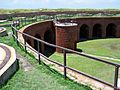
On the top of civil war era Fort Massachusetts on Ship Island.
-
Fort Massachusetts.
-
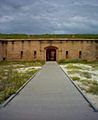
Entrance to Fort Massachusetts.
-

Ship Island before (top) and after (below) Hurricane Katrina.


