Dauphin Island, Alabama facts for kids
Quick facts for kids
Dauphin Island, Alabama
|
|||
|---|---|---|---|
|
Town
|
|||
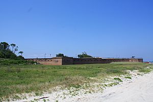
Fort Gaines and seashore vegetation on the eastern end of Dauphin Island
|
|||
|
|||
| Motto(s):
"Sunset Capital of Alabama"
|
|||
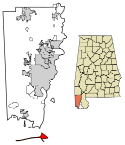
Location in Mobile County, Alabama
|
|||
| Country | United States | ||
| State | Alabama | ||
| County | Mobile | ||
| Area | |||
| • Total | 165.95 sq mi (429.81 km2) | ||
| • Land | 6.26 sq mi (16.20 km2) | ||
| • Water | 159.69 sq mi (413.61 km2) | ||
| Elevation | 7 ft (2 m) | ||
| Population
(2020)
|
|||
| • Total | 1,778 | ||
| • Density | 284.21/sq mi (109.72/km2) | ||
| Time zone | UTC−6 (Central Standard Time (CST)) | ||
| • Summer (DST) | UTC−5 (Central Daylight Time (CDT)) | ||
| ZIP code |
36528
|
||
| Area code(s) | 251 | ||
| FIPS code | 01-19744 | ||
| GNIS feature ID | 0117086 | ||
Dauphin Island is a cool island town in Mobile County, Alabama. It's located on a barrier island of the same name, right in the Gulf of Mexico. The town officially became a town in 1988. In 2020, about 1,778 people lived there.
The island was first called Massacre Island. But it was later renamed after the "dauphin," who was the heir to the French king, Louis XIV of France. The word dauphin means dolphin in French, which can be a bit confusing!
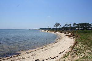
Dauphin Island is one of the Mississippi–Alabama barrier islands. The Gulf of Mexico is to its south, and the Mississippi Sound and Mobile Bay are to its north. The eastern part of the island is wider and has lots of pine trees and saw palmettos. The western part is narrower with fewer trees.
The island is home to many interesting places. You can visit Fort Gaines, the Dauphin Island Sea Lab, and the Estuarium, which is a public aquarium. There are also boat ramps, a big public pier, and many places to eat. People love to visit the beaches and go fishing around the island. A bridge called the Gordon Persons Bridge connects the island to the mainland.
Dauphin Island is a very important spot for birds! It has several bird sanctuaries, including the large 164-acre (66 ha) Audubon Bird Sanctuary. Many birds stop here to rest when they are migrating north from South America. It's the first land they see after a long flight!
Contents
Island History: A Journey Through Time
Ancient Times and First Visitors
Long ago, about 1,500 years ago, Native American people from the Mississippian group lived on the island, at least during certain seasons. They left behind shell middens (piles of shells). You can still see some of these at Shell Mound Park today.
In 1519, a Spanish explorer named Alonso Álvarez de Pineda was the first European to visit the island. He even drew a very accurate map of it!
French Arrival and Renaming the Island
The island's French story began on January 31, 1699. That's when explorer Pierre Le Moyne, sieur d'Iberville, who helped start French Louisiana, arrived near Mobile Bay. He anchored his ship close to the island. D'Iberville mistakenly named it Île du Massacre (Massacre Island). He found a large pile of human skeletons there. It turned out to be an ancient burial mound that a hurricane had uncovered, not a massacre site. But the dramatic name stuck for a while!
D'Iberville later set up a port on the island for Fort Louis de La Louisiane. He chose the island because it had lots of wood, fresh water, and a deep harbor. The settlement had a fort, a chapel, warehouses, and homes.
The island became a big trading center. Goods from places like Haiti, Mexico, Cuba, and France were brought here. Smaller boats then carried the goods into Mobile Bay because the bay was too shallow for big ships.
In 1719, the first people brought to Alabama against their will arrived at Dauphin Island. After the French and Indian War ended in 1763, the island became British territory. After the American Revolutionary War, Spain took control of the island until 1812.
In 1795, after a treaty between Spain and the United States, new settlers started moving to Alabama. Around 1805, the Chickasaw, Cherokee, and Choctaw people had to give up their lands to the government. The Creek tribes fought hard to keep their lands, but they also had to give them up in 1813.
Fort Gaines and the Civil War
Fort Gaines is on the eastern tip of the island. It was built between 1821 and 1848. During the Civil War, soldiers from the Confederate forces took over the fort in 1861. But the Union Army captured it during the Battle of Mobile Bay.
The first Sand Island Lighthouse was built in 1834. A taller one was built later, but Confederate forces destroyed it. The lighthouse you see today was built in 1873 and was used until 1970. It's now a historic place.
In 2023, a large alligator was seen riding waves and sunbathing on Dauphin Island beach! Alligators usually live in fresh water, but they can handle salt water too.
Island Geography and Climate
How Big is Dauphin Island?
Dauphin Island is about 15 miles (24 km) long from east to west. It separates the Gulf of Mexico from the Mississippi Sound and Mobile Bay. For most of its length, the island is less than 0.25 miles (0.40 km) wide. But the eastern part is wider, over 1 mile (1.6 km) across. Most of the town's total area, about 96%, is actually water!
The Dauphin Island Bridge, also known as the Gordon Persons Bridge, is the only road that connects the island to the mainland. It's about 27 miles (43 km) north to Tillmans Corner. Downtown Mobile is about 37 miles (60 km) north of the island.
Weather on the Island
Dauphin Island has a humid subtropical climate. This means it has hot, humid summers and generally mild to cool winters.
| Climate data for Dauphin Island #2, Alabama (1991–2020 normals, extremes 1975–present) | |||||||||||||
|---|---|---|---|---|---|---|---|---|---|---|---|---|---|
| Month | Jan | Feb | Mar | Apr | May | Jun | Jul | Aug | Sep | Oct | Nov | Dec | Year |
| Record high °F (°C) | 81 (27) |
80 (27) |
83 (28) |
88 (31) |
95 (35) |
99 (37) |
101 (38) |
99 (37) |
97 (36) |
93 (34) |
85 (29) |
85 (29) |
101 (38) |
| Mean maximum °F (°C) | 70.5 (21.4) |
71.3 (21.8) |
76.5 (24.7) |
81.1 (27.3) |
88.1 (31.2) |
91.3 (32.9) |
93.7 (34.3) |
93.0 (33.9) |
91.1 (32.8) |
85.6 (29.8) |
79.2 (26.2) |
73.6 (23.1) |
94.7 (34.8) |
| Mean daily maximum °F (°C) | 58.6 (14.8) |
61.5 (16.4) |
66.8 (19.3) |
73.5 (23.1) |
80.8 (27.1) |
86.2 (30.1) |
88.2 (31.2) |
88.1 (31.2) |
85.2 (29.6) |
77.4 (25.2) |
67.8 (19.9) |
61.2 (16.2) |
74.6 (23.7) |
| Daily mean °F (°C) | 52.3 (11.3) |
55.4 (13.0) |
61.3 (16.3) |
68.3 (20.2) |
76.0 (24.4) |
81.3 (27.4) |
83.2 (28.4) |
83.2 (28.4) |
80.3 (26.8) |
72.0 (22.2) |
61.7 (16.5) |
55.2 (12.9) |
69.2 (20.7) |
| Mean daily minimum °F (°C) | 46.1 (7.8) |
49.4 (9.7) |
55.8 (13.2) |
63.1 (17.3) |
71.2 (21.8) |
76.4 (24.7) |
78.2 (25.7) |
78.3 (25.7) |
75.5 (24.2) |
66.7 (19.3) |
55.6 (13.1) |
49.2 (9.6) |
63.8 (17.7) |
| Mean minimum °F (°C) | 30.7 (−0.7) |
35.0 (1.7) |
40.4 (4.7) |
50.3 (10.2) |
60.9 (16.1) |
70.1 (21.2) |
71.8 (22.1) |
72.5 (22.5) |
67.3 (19.6) |
52.9 (11.6) |
42.1 (5.6) |
36.8 (2.7) |
28.5 (−1.9) |
| Record low °F (°C) | 9 (−13) |
19 (−7) |
23 (−5) |
35 (2) |
50 (10) |
55 (13) |
65 (18) |
64 (18) |
57 (14) |
37 (3) |
24 (−4) |
11 (−12) |
9 (−13) |
| Average precipitation inches (mm) | 5.23 (133) |
4.35 (110) |
4.90 (124) |
5.16 (131) |
5.01 (127) |
5.87 (149) |
6.80 (173) |
6.80 (173) |
5.24 (133) |
3.52 (89) |
3.86 (98) |
5.13 (130) |
61.09 (1,552) |
| Average precipitation days (≥ 0.01 in) | 12.2 | 10.2 | 9.5 | 7.4 | 6.8 | 10.2 | 11.6 | 12.1 | 8.4 | 6.8 | 8.1 | 11.5 | 114.8 |
| Source: NOAA | |||||||||||||
Who Lives on Dauphin Island?
| Historical population | |||
|---|---|---|---|
| Census | Pop. | %± | |
| 1990 | 824 | — | |
| 2000 | 1,371 | 66.4% | |
| 2010 | 1,238 | −9.7% | |
| 2020 | 1,778 | 43.6% | |
| U.S. Decennial Census | |||
In 2020, the population of Dauphin Island was 1,778 people.
A Look at the 2010 Census
Back in 2010, there were 1,238 people living in Dauphin Island. Most people (97.3%) were White. About 1% were Native American, and a small number were Black or Asian. About 0.7% of the population was Hispanic or Latino.
There were 582 households on the island. About 13.2% of these households had kids under 18. Many households (57.2%) were married couples. The average age of people living on the island was 53 years old.
The average income for a household was about $56,731.
A Look at the 2020 Census
| Race | Num. | Perc. |
|---|---|---|
| White (non-Hispanic) | 1,615 | 90.83% |
| Black or African American (non-Hispanic) | 5 | 0.28% |
| Native American | 19 | 1.07% |
| Asian | 12 | 0.67% |
| Pacific Islander | 3 | 0.17% |
| Other/Mixed | 82 | 4.61% |
| Hispanic or Latino | 42 | 2.36% |
In 2020, there were 1,778 people living in 585 households.
Education on the Island
The schools on Dauphin Island are part of the Mobile County Public School System. There is one public school on the island, Dauphin Island Elementary School. After elementary school, students go to Alba Middle School and Alma Bryant High School in Bayou La Batre.
The Dauphin Island Sea Lab is also on the island. It's a special place where people study marine science and the environment.
Dauphin Island's Coat of Arms
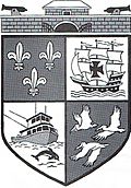
The coat of arms for Dauphin Island tells a story about its history.
- At the top, you see Fort Gaines with two cannons. This shows the island's role during the Civil War.
- The boat is a shrimping vessel, representing how many island residents make a living.
- The dolphin is an animal often seen in the waters around the island.
- The birds are pelicans, which are very common along the Gulf coast.
- The fleur-de-lis symbol reminds us of France's time on the island from 1699 to 1764.
- The sailing ship is a Spanish galleon, showing Spain's influence in the area from 1781 to 1813.
Hurricanes: Island Challenges
Dauphin Island has been hit by many hurricanes over the years. Here are some of the more recent ones:
- In 1969, Hurricane Camille flooded most of the island.
- In 1979, Hurricane Frederic destroyed the bridge that connected the island to the mainland.
- In 1985, Hurricane Elena brought very strong winds, over 130 mph (210 km/h).
- In 1997, Hurricane Danny caused a lot of flooding on the east side of the island.
- In 1998, Hurricane Georges destroyed 41 homes.
- In 2004, Hurricane Ivan covered almost a quarter of the island with about two feet of water.
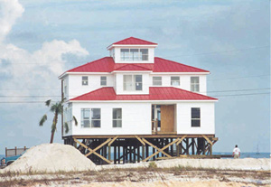
- On August 29, 2005, Hurricane Katrina caused damage to parts of Dauphin Island. Some homes on the west end were destroyed, and a new channel called the Katrina Cut formed. However, many areas on the central and east end didn't flood as much. An oil drilling platform was even pushed almost 60 miles (97 km) from its spot by the hurricane!
- On September 14, 2020, Hurricane Sally brought storm surge that flooded the island.
Fun Things to Do on Dauphin Island
There are many cool places to visit on Dauphin Island!
- The old walled Fort Gaines is on the east end of the island.
- You can take a ferry from nearby Fort Morgan to get to the island.
- Close to the ferry dock is The Estuarium. This is an aquarium where you can see many different fish and animals that live in Alabama's fresh and saltwater.
The Dauphin Island Heritage and Arts Council shows art by local artists and shares information about the island's history. They also organize the yearly Dauphin Island Native American Festival.
See also
 In Spanish: Dauphin Island para niños
 | Toni Morrison |
 | Barack Obama |
 | Martin Luther King Jr. |
 | Ralph Bunche |


