
Matakana Island facts for kids

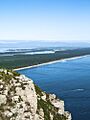
Matakana Island as seen from the top of Mount Maunganui
|
|
| Geography | |
|---|---|
| Location | Bay of Plenty Region |
| Coordinates | 37°35′S 176°05′E / 37.583°S 176.083°E |
| Total islands | 5 |
| Area | 64.56 km2 (24.93 sq mi) |
| Length | 20 km (12 mi) |
| Width | 3 km (1.9 mi) |
| Highest elevation | 18 m (59 ft) |
| Administration | |
| Territorial authority | Western Bay of Plenty District |
| Ward | Waihi Beach/Katikati |
| Electorate | Coromandel |
| Demographics | |
| Population | 250 (June 2023) |
| Pop. density | 3.9 /km2 (10.1 /sq mi) |
| Ethnic groups | Maori |

Matakana Island is a long, flat island located in the western Bay of Plenty region of New Zealand's North Island. It stretches about 20 kilometres (12 mi) long but is usually less than 3 kilometres (1.9 mi) wide. For hundreds of years, Māori tribes, mainly linked to Ngāi Te Rangi, have lived on the island.
The island has two main parts. One part, about 5,000 acres (2,023 ha), is used for farms and orchards and is located on the side facing the harbour. Most people live here. The other part, about 10,000 acres (4,047 ha), is covered in forest and faces the open Pacific Ocean. A smaller island called Rangiwaea Island is just off Matakana's southern coast.
According to the 2018 census, 183 people live on Matakana Island. This number was 255 in the 2013 Census. This makes Matakana Island one of the least populated areas in the Western Bay of Plenty. There are only about 90 homes where people live. Most people on the island follow the Ratana Church or the Catholic Church.
Contents
History and Culture of Matakana Island
How Land Ownership Changed
In the 1800s, there were some big changes in land ownership around Tauranga. Even though a lot of land was taken by the government, much of it was later given back to Māori. Matakana Island itself was not taken.
The western part of Matakana Island, which is about 5,000 acres (2,023 ha) of farmland, was bought and sold a few times between 1869 and 1874. Eventually, the government bought it and then gave it back to the same Māori people who had sold it earlier, without any cost.
The coastal part of the island, about 10,000 acres (4,047 ha) of sand dunes, was bought by a person named William Daldy in 1878.
Important Meeting Places: Marae
Matakana Island is home to three marae (traditional Māori meeting grounds). These marae are connected to different groups, or hapū, of the Ngāi Te Rangi tribe:
- Kutaroa Marae and its meeting house, Tauaiti, are for the Ngāti Tauaiti hapū.
- Opureora Marae and its meeting house, Tuwhiwhia, are for the Ngāi Tuwhiwhia and Ngāti Tauaiti hapū.
- Te Rangihouhiri Marae (also called Oruarahi Marae) and its meeting house, Te Rangihouhiri, are for the Ngāi Tamawhariua hapū.
In 2020, the New Zealand Government provided money to help upgrade Te Rangihouhiri Marae and other marae. This project also helped create jobs.
There are also two marae sites on the nearby Rangiwaea Island that belong to Ngāi Te Rangi hapū:
- Rangiwaea Marae and its meeting house, Te Haka a Te Tupere, are a gathering place for Ngāi Tauwhao.
- Oponui Marae was another meeting place for Te Ngare, but it was taken apart between the 1980s and 2007.
People Living on Matakana Island
Matakana Island covers about 64.56 km2 (24.93 sq mi). As of June 2023, , an estimated 250 people live there. This means there are about 3.9 people for every square kilometre.
| Historical population | ||
|---|---|---|
| Year | Pop. | ±% p.a. |
| 2006 | 225 | — |
| 2013 | 255 | +1.80% |
| 2018 | 183 | −6.42% |
At the 2018 New Zealand census, 183 people lived on Matakana Island. This was a decrease of 72 people since the 2013 census. There were 78 households, with slightly more females (96) than males (87). The average age was 40.6 years. About 18% of the people were under 15 years old, and about 20% were 65 or older.
Most people on the island are Māori (95.1%), with some European/Pākehā (13.1%) and Pacific peoples (1.6%). Some people identify with more than one ethnic group. Only a small number of people (3.3%) were born outside New Zealand.
When asked about their religion, about 28% said they had no religion. About 33% were Christian, and about 28% followed Māori religious beliefs.
For those aged 15 and older, about 12% had a university degree or higher. About 22% had no formal qualifications. The average income was $20,100, which is lower than the national average. Most people (36%) worked full-time, and 24% worked part-time. A small number (2%) were unemployed.
Geography and Nature

Matakana Island acts like a natural shield, protecting the entrance to the Tauranga harbour. It stretches from Bowentown all the way to Mount Maunganui. Most of the island is covered with pine trees, but some areas are cleared for the people who live there.
The island has a small population density, meaning not many people live in a large area. Matakana Island is the third largest island connected to the North Island by area, and the fifteenth largest in all of New Zealand.

The island's long, white sandy beach is a popular spot for surfers. Surfers can take a water taxi from Mount Maunganui or, if the weather is good, paddle across the mouth of Tauranga Harbour to reach the island. The ocean side of Matakana is also an important nesting place for many sea birds, including the endangered New Zealand dotterel. In 2007, it was estimated that 325 sting rays lived in the waters between Matakana Island and Rangiwaea Island.
Rangiwaea Island: A Nearby Neighbour
Rangiwaea Island is located just off the southeast coast of Matakana Island. It is a low-lying island, over 3 km (1.9 mi) long, and its highest point is about 19 m (62 ft). Like Matakana, the history of land ownership on Rangiwaea was complicated during colonisation, but land that was taken was returned in 1886. Today, the main products from Rangiwaea Island include kiwifruit, avocado, timber, and cattle. Other smaller islands nearby are Tahunamanu, Motungaio, and Motutangaroa Islet.
Education on the Island
Te Kura o Te Moutere o Matakana is a primary school on the island for students from Year 1 to 8. It is a co-educational school that teaches mainly in the Māori language (a Māori language immersion school). As of February 2024, the school has a roll of 26 students.
Images for kids
-
Matakana Island as seen from the top of Mount Maunganui
-
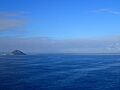
Matakana Island Aotearoa New Zealand from the North
-
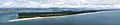
Matakana Island and Tauranga Harbour, Bay of Plenty, New Zealand - View from Mauao (Mount Maunganui)
-
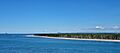
Northern Matakana from Bowentown. Mount Maunganui is centre background
