
1886 Charleston earthquake facts for kids

Damage on Tradd Street
|
|

 
|
|
| UTC time | 1886-09-01 02:51:00 |
|---|---|
| Magnitude | 6.9–7.3 Mw |
| Epicenter | 32°54′N 80°00′W / 32.9°N 80.0°W |
| Type | Unknown |
| Total damage | $5–6 million |
| Casualties | 60 deaths |
The 1886 Charleston earthquake was a powerful natural disaster in the Southeastern United States. It hit Charleston, South Carolina on the night of August 31, 1886. Scientists measure earthquakes with the moment magnitude scale. They estimate this earthquake had a score of 6.9 to 7.3. It also reached a top level on the Mercalli intensity scale. It remains one of the strongest events on the East Coast of the United States.
Contents
What Caused the Great Charleston Earthquake?
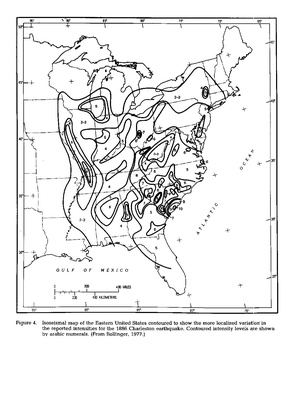
Most quakes happen along the edges of giant moving crust pieces. This event was an earthquake inside a tectonic plate. It occurred far away from any plate boundary. The ground broke along deep underground fault cracks. These cracks first formed when the supercontinent Pangaea broke apart millions of years ago. Modern pushes from the North American plate still squeeze these old lines. The shaking was centered in the Charleston seismic zone. Shaking traveled across North America toward Boston, Chicago, and Milwaukee, Wisconsin. People felt it westward in New Orleans and south across Florida. It was even felt on distant islands like Cuba and Bermuda.
How the Ground Changed
The ground shook violently during the main shock. Water and loose dirt shot upward to create a sand boil. This happened because of wet dirt turning into liquid muck. Geologists like Roger Bilham and Susan Hough later studied the ground near Summerville, South Carolina. They found shifted tracks on the South Carolina Railroad. The break stretched past Pinopolis, South Carolina.
Discovering the Historic City Damage

.jpg)
.webp)

Buildings made of brick took the hardest hit. Wood-frame houses stayed together much better. Bricks cracked and fell into busy streets. Historic places like the Old White Meeting House fell down in Dorchester County, South Carolina.
Rumbling shocks broke long train rails and derailing steam trains. Collapsing dams sent muddy floodwaters across fields and roads. Strong shaking reached Tybee Island, Georgia over 60 miles away. Cracks showed up in walls across Alabama, Ohio, Kentucky, Virginia, and West Virginia.
Repairing the Buildings and Preparing for the Future
Builders fixed ruined houses with long iron rods called an earthquake bolt. These metal pieces held outside walls together on an older brick structure. A local artist named George LaGrange Cook took photos of ruined buildings. Today, children can see his pictures inside the Gibbes Museum of Art.
See also
- Geology of the United States
- List of earthquakes in South Carolina
- List of earthquakes in the United States
- List of historical earthquakes
