Richard B. Russell Lake facts for kids
Quick facts for kids Richard B. Russell Lake |
|
|---|---|

Richard B. Russell Dam
|
|
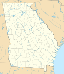
| Location | Georgia / South Carolina |
| Coordinates | 34°05′30″N 82°37′48″W / 34.091762°N 82.629976°W |
| Type | reservoir |
| Primary inflows | Savannah River |
| Primary outflows | Savannah River |
| Basin countries | United States |
| Surface area | 26,650 acres (108 km2) |
| Max. depth | 167 ft (51 m) |
| Shore length1 | 540 mi (870 km) |
| Surface elevation | 475 ft (145 m) |
| 1 Shore length is not a well-defined measure. | |
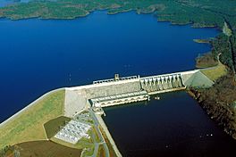
Richard B. Russell Lake is a large lake located on the border between Georgia and South Carolina. Many local people simply call it "Lake Russell." This lake is actually a reservoir, which means it is a big, artificial lake. It was created by the U.S. Army Corps of Engineers. They built a huge wall, called the Richard B. Russell Dam, across the Savannah River.
The lake was named after a famous U.S. Senator, Richard Brevard Russell, Jr.. It covers about 26,650 acres (108 square kilometers) of water. The shoreline of the lake stretches for an amazing 540 miles (870 kilometers)!
Contents
Creating the Lake
The U.S. Army Corps of Engineers started filling the lake in October 1983. It took about a year for the lake to reach its full size. By December 1984, the water level was at 475 feet (145 meters).
Why the Lake Looks Full
Unlike some other nearby lakes, the water level in Lake Russell does not change much. It usually stays within 5 feet (1.5 meters) of its full level. This is because of how it was designed. This design makes the lake always look full and beautiful.
No Private Shoreline Use
A special rule for Lake Russell is that no one can build private homes or docks along its shoreline. This rule is different from other lakes nearby. It means the land around Lake Russell is kept natural and open for everyone to enjoy.
Discovering the Past
Before the lake was filled, the area had many important historical sites. Experts worked hard to explore and dig up these sites. They wanted to learn about them before they were covered by water.
Ancient Discoveries
Some of the places found included an old plantation called Millwood Plantation. They also found Fort Independence, which was an old fort. A very important discovery was a Native American village and a special mound. These sites tell us about the people who lived there long ago.
The Underwater Bridge
The lake also covered an old bridge called the Georgia–Carolina Memorial Bridge. This bridge was not taken apart. It still stands intact, hidden beneath the water of the lake.
Fun at the Lake
Because of the rules, the shoreline of Lake Russell is mostly undeveloped. This means you won't see many houses or private buildings along the edges. Instead, you will find natural areas, state parks, and places for day visits.
Protecting the Shoreline
The U.S. Army Corps of Engineers owns a 300-foot (91-meter) wide strip of land all around the lake. This land is a "buffer zone." It helps protect the natural environment and makes up for the habitat lost when the lake was created. This natural shoreline gives Lake Russell a very different and wilder feel compared to other lakes.
 | Victor J. Glover |
 | Yvonne Cagle |
 | Jeanette Epps |
 | Bernard A. Harris Jr. |


