St. Marys River (Florida–Georgia) facts for kids
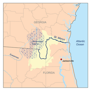
The St. Marys River is a long river in the southeastern United States. It is about 126 miles (203 km) long. This river forms part of the border between the states of Georgia and Florida. It also marks the southernmost point in Georgia.

The St. Marys River starts as a tiny stream called River Styx. This stream flows from the western edge of a place called Trail Ridge. Trail Ridge is an old landform that used to be a barrier island or sand dune system. The stream then goes into the southeastern part of the Okefenokee Swamp.
Inside the swamp, the river's path can be hard to see for a bit. It first curves to the northwest. Then, it turns back to the southwest and becomes a clear stream again. At this point, it is called the St. Marys River. Another stream, Moccasin Creek, joins it.
The river then leaves the Okefenokee Swamp near Baxter, Florida, and Moniac, Georgia. From there, it flows south, then east, then north, and finally east-southeast. The St. Marys River eventually empties its waters into the Atlantic Ocean. This happens near the towns of St. Marys, Georgia and Fernandina Beach, Florida.
River's Name
The official name of the river is "St. Marys River." The United States Board on Geographic Names is a group that decides on place names. They usually suggest not using apostrophes in names like "St. Mary's." That is why it is spelled "St. Marys River."
See also
 In Spanish: Río Santa María (Florida) para niños
 | Toni Morrison |
 | Barack Obama |
 | Martin Luther King Jr. |
 | Ralph Bunche |


