
St. Marys, Georgia facts for kids
Quick facts for kids
St. Marys, Georgia
|
||
|---|---|---|
 |
||
|
||

Location in Camden County and the state of Georgia
|
||
| Country | United States of America | |
| State | Georgia | |
| County | Camden | |
| Area | ||
| • Total | 25.00 sq mi (64.74 km2) | |
| • Land | 22.82 sq mi (59.11 km2) | |
| • Water | 2.18 sq mi (5.63 km2) | |
| Elevation | 10 ft (3 m) | |
| Population
(2020)
|
||
| • Total | 18,256 | |
| • Density | 799.93/sq mi (308.85/km2) | |
| Time zone | UTC-5 (Eastern (EST)) | |
| • Summer (DST) | UTC-4 (EDT) | |
| ZIP Code |
31558
|
|
| Area code(s) | Area code 912 | |
| FIPS code | 13-67984 | |
| GNIS feature ID | 0356510 | |

St. Marys is a city in Georgia, located right on the St. Marys River. It's in the southern part of Camden County. In 2020, about 18,256 people lived here. This was more than the 17,121 people counted in 2010.
The state of Florida is just south across the river. Cumberland Island National Seashore is to the northeast. The city of Kingsland is to the west. Bigger cities like Jacksonville, Florida and Savannah, Georgia are also nearby.
St. Marys is home to the visitor center for Cumberland Island National Seashore. You can also visit the St. Marys Submarine Museum here. Crooked River State Park is another popular spot. The city is next to Kings Bay Naval Submarine Base. This base is a home port for several large submarines. St. Marys also hosts a fun event each year called the St. Marys Rock Shrimp Festival.
Contents
A Look at St. Marys History
The area around the St. Marys River was first explored in the mid-1500s. Spanish explorers came here as part of their efforts to settle Spanish Florida. Nearby St. Augustine was their main city. The original Spanish settlement in this area started in 1566. This makes it one of the oldest places in the United States where people have continuously lived.
After the American Revolutionary War, people in Camden County wanted to create a new town. On November 20, 1787, they signed a plan for "a town on the St. Marys." Twenty people were part of this plan. Each person received land lots in the new town. These founders are listed on a historical marker in downtown St. Marys.
The new town's first borders were near the waterfront. For a while, people called it St. Marys or St. Patrick's. Some say the name comes from the St. Marys River. Others believe it's from an old Spanish mission called Santa Maria. Georgia officially recognized St. Marys as a town in 1792. It became an incorporated city in November 1802.
Oak Grove Cemetery is part of the St. Marys Historic District. It was created outside the town's western border in 1787.
Important Treaties and Trade
On June 29, 1796, an important agreement was signed near St. Marys. This was the Treaty of Colerain. It was signed between the United States and the Creek Nation. The Creek people were the original inhabitants of this land. Langley Bryant, one of St. Marys' founders, helped as an interpreter.
St. Marys became an official port of entry for the United States in 1799. This meant ships could legally bring goods into the country here. During the early 1800s, St. Marys was a busy place for trade.
During the War of 1812, the British captured a fort near St. Marys. This was the Battle of Fort Peter. The British occupied the town for about a month. Later, during the American Civil War, the United States Navy attacked buildings along the town's shore. St. Marys was the county seat for Camden County from 1869 to 1923.
St. Marys Geography
St. Marys is located in the southern part of Camden County. It sits on the north bank of the St. Marys River. The state of Florida is just across the river to the south. The city of Kingsland is right next to St. Marys on its western side.
The city covers a total area of about 64.5 square kilometers (25 square miles). Most of this area is land, about 58.3 square kilometers (22.5 square miles). The rest, about 6.2 square kilometers (2.4 square miles), is water.
St. Marys Climate
St. Marys has a humid subtropical climate. This means it has long, hot summers. The winters are usually short and mild.
| Climate data for St. Marys, Georgia | |||||||||||||
|---|---|---|---|---|---|---|---|---|---|---|---|---|---|
| Month | Jan | Feb | Mar | Apr | May | Jun | Jul | Aug | Sep | Oct | Nov | Dec | Year |
| Record high °F (°C) | 88 (31) |
91 (33) |
92 (33) |
94 (34) |
100 (38) |
104 (40) |
102 (39) |
102 (39) |
99 (37) |
96 (36) |
93 (34) |
85 (29) |
104 (40) |
| Mean daily maximum °F (°C) | 63 (17) |
66 (19) |
71 (22) |
77 (25) |
83 (28) |
88 (31) |
91 (33) |
89 (32) |
86 (30) |
79 (26) |
72 (22) |
65 (18) |
78 (26) |
| Mean daily minimum °F (°C) | 44 (7) |
47 (8) |
53 (12) |
59 (15) |
67 (19) |
73 (23) |
75 (24) |
75 (24) |
73 (23) |
65 (18) |
56 (13) |
48 (9) |
61 (16) |
| Record low °F (°C) | 4 (−16) |
20 (−7) |
22 (−6) |
37 (3) |
40 (4) |
51 (11) |
63 (17) |
61 (16) |
52 (11) |
39 (4) |
24 (−4) |
12 (−11) |
4 (−16) |
| Average precipitation inches (mm) | 3.42 (87) |
3.32 (84) |
3.92 (100) |
2.82 (72) |
2.31 (59) |
5.27 (134) |
5.52 (140) |
5.82 (148) |
6.91 (176) |
4.59 (117) |
2.08 (53) |
2.95 (75) |
48.93 (1,245) |
St. Marys Population
| Historical population | |||
|---|---|---|---|
| Census | Pop. | %± | |
| 1810 | 268 | — | |
| 1820 | 771 | 187.7% | |
| 1840 | 206 | — | |
| 1860 | 650 | — | |
| 1870 | 702 | 8.0% | |
| 1890 | 575 | — | |
| 1900 | 529 | −8.0% | |
| 1910 | 691 | 30.6% | |
| 1920 | 824 | 19.2% | |
| 1930 | 732 | −11.2% | |
| 1940 | 733 | 0.1% | |
| 1950 | 1,348 | 83.9% | |
| 1960 | 3,272 | 142.7% | |
| 1970 | 3,408 | 4.2% | |
| 1980 | 3,596 | 5.5% | |
| 1990 | 8,187 | 127.7% | |
| 2000 | 13,761 | 68.1% | |
| 2010 | 17,121 | 24.4% | |
| 2020 | 18,256 | 6.6% | |
| U.S. Decennial Census 1850-1870 1870-1880 1890-1910 1920-1930 1940 1950 1960 1970 1980 1990 2000 2010 |
|||
The table above shows how the population of St. Marys has changed over many years. In 2020, the city had 18,256 people. There were 6,966 households and 4,998 families living in the city.
| Race | Num. | Perc. |
|---|---|---|
| White (non-Hispanic) | 12,548 | 68.73% |
| Black or African American (non-Hispanic) | 2,989 | 16.37% |
| Native American | 68 | 0.37% |
| Asian | 249 | 1.36% |
| Pacific Islander | 15 | 0.08% |
| Other/Mixed | 1,095 | 6.0% |
| Hispanic or Latino | 1,292 | 7.08% |
Notable People from St. Marys
- Tina Cornely, a person known for helping others (philanthropist)
- Stump Mitchell, an American football coach and former player
Images for kids
-
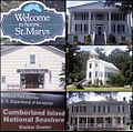
A collection of images showing different parts of St. Marys, Georgia.
-
The official seal of the city of St. Marys, Georgia.
-
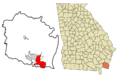
A map showing St. Marys highlighted within Camden County, Georgia.
See also
 In Spanish: St. Marys (Georgia) para niños
