Salt River (Kentucky) facts for kids
Quick facts for kids Salt River |
|
|---|---|

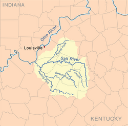
Salt River watershed
|
|
| Country | United States |
| Physical characteristics | |
| Main source | Parksville, Kentucky 500 feet (152 m) |
| River mouth | Hardin County, Kentucky |
| Length | 150 miles (240 km) |
| Basin features | |
| Basin size | Floyds Fork Rolling Fork Beech Fork Chaplin River |
The Salt River is a 150-mile-long (240 km) river in the U.S. state of Kentucky. It flows through a large area of 2,920 square miles (7,600 km2). The river starts near Parksville, Kentucky, and flows into the Ohio River near West Point, Kentucky. Two important lakes, Taylorsville Lake and Guist Creek Lake, are also part of its water system.
The Salt River used to flood often, especially the Rolling Fork part. This was because it ran along steep hills. A very big flood happened in 1937, affecting places like Louisville, Kentucky. To help with this, the Taylorsville Lake Dam was built in the 1970s. This dam has greatly reduced the worst floods. Even so, some flooding can still happen, especially near Taylorsville, Kentucky. This is mostly from water flowing back from the Ohio River. The river gets the most rain in May and the least in September.
Some ideas for building more dams on the Rolling Fork and Beech Fork rivers were considered. However, these plans were not carried out because they were too expensive. The Chaplin River, which is a branch of the Beech Fork, starts close to where the Salt River begins.
Contents
Amazing Wildlife Along the Salt River
The Salt River area is home to many special animals and plants. Some parts of the river are protected by the Nature Conservancy. This is because they have rare creatures and unique plants. The floods helped create rich, wet lands. These lands support many different types of wetland homes for animals.
Animals of the Salt River
You can find many common animals here. These include turtles, fish, and different kinds of waterfowl. Deer, river otters, and beavers also live in the area. But there are also some very rare animals. These include the Indiana bat and the gray bat. You might also find the fanshell (a type of mussel) and the Louisville (Knob Creek) crawfish.
Unique Plants of the River Valley
Besides the animals, several rare or special plants grow here. These include Crawe's sedge and the small white lady's-slipper. Other unique plants are glade cress, Prairie dropseed, silky aster, and Eggleston's violet.
The Geology of the Salt River Area
The Salt River's water system covers about 2,920 square miles (7,600 km2). This makes it the fifth largest water system in Kentucky. Much of the land around the river has deep ridges. These ridges become less steep as the river gets closer to the Ohio River. The river itself is about 480 to 500 feet (146 to 152 m) above sea level.
Understanding the River's Landscape
The river valley is fairly shallow, about 490 to 530 feet (150 to 160 m) above sea level. But steep hillsides quickly rise to 650 to 750 feet (200 to 230 m). This is a common height for land in central Kentucky. This creates flat-topped ridges with narrow valleys in between. These valleys are often carved out by small creeks flowing into the river.
Flash floods can happen quickly in these narrow valleys. This makes it hard to travel between the ridges. People often had to take long, winding paths. Because of this, people living in the valleys and those on the ridge-tops did not see each other very often.
Rapids and Local Climate
In Bullitt County, Kentucky, the Salt River has class I rapids. This section of the river is about 11.5 miles (19 km) long. On cool mornings, fog often fills the valley. This makes the valley cooler and more stable in temperature. Meanwhile, the ridges can be hot and dry. Crops like Tobacco, corn, and soybeans grow well in the lower fields. They can even do well when droughts make the drier, hotter ridges suffer.
History of the Salt River

The river got its name from a place called Bullitt's Lick. This was a salt lick where animals gathered. Henry Crist founded a settlement there in 1779. People have used the river for travel and food for a very long time. Old Native American tools are still found along the river valley. Farmers and construction workers often discover them.
Early settlers built log cabins and towns along the riverbanks. They used the river for water, power, and transportation. The flat areas along the river and the water itself made travel easier through the hilly land.
The Salt River During the Civil War
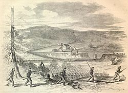
During the American Civil War, a fort with earth walls was built on a tall hill. It overlooked the Ohio River, near the Salt River. This fort protected travel through Louisville and south along the Ohio River road. This road later became known as the Dixie Highway. The fort also guarded against Southern forces attacking from the Ohio or up the Salt River. Fort Duffield is one of the best-preserved Civil War forts made of earth. It shows how important river access was for early travelers.
In 1983, the U.S. Army Corps of Engineers finished building a dam on the river. This dam, just above Taylorsville, created Taylorsville Lake.
Economy and Use of the River
In early settlements, high water levels helped ship timber and other local products downstream to the Ohio River. When the water was calmer, small boats could travel upstream. This helped settlers move goods to farms that were far away. The river also caused floods in towns like Taylorsville and Shepherdsville. This changed how these towns were built and how they grew.
Many mills used to be located along the Salt River and its smaller branches. They used the river's water to grind grain for feed and flour. They also used it to saw lumber and for other tasks. Examples include mills at Bullitt's Lick and Bell's Mill on Floyd's Fork.
The Salt River was a main source of water for many towns and farms. Towns like Taylorsville, Mount Washington, and Shepherdsville used to get their water from the river. Later, water lines were extended from Louisville, providing water from other sources.
 | Kyle Baker |
 | Joseph Yoakum |
 | Laura Wheeler Waring |
 | Henry Ossawa Tanner |

