
Mornington, County Meath facts for kids
Quick facts for kids
Mornington
Baile Uí Mhornáin
|
|
|---|---|
|
Village
|
|

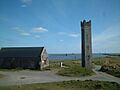
Maiden Tower, Mornington, and Mouth of River Boyne
|
|

Mornington
Location in Ireland
|
|
| Country | Ireland |
| Province | Leinster |
| County | County Meath |
| Population
(2022)
|
|
| • Total | 15,642 |
| Urban area of Laytown–Bettystown–Mornington–Donacarney | |
| Irish Grid Reference | O149759 |
Mornington (which means "town of the mariner" in Irish) is a village on the coast of County Meath, Ireland. It sits where the River Boyne meets the sea. Mornington is about 5 kilometers (3 miles) from the center of Drogheda.
It is part of a larger urban area that includes the nearby villages of Laytown, Bettystown, and Donacarney. In 2022, this combined area had a population of 15,642 people. The village is bordered by the River Boyne estuary to the north and the Irish Sea to the east.
Mornington can also refer to a wider area. This includes a "half-parish" within the local Roman Catholic parish. It was also a post office area until the 1980s.
Contents
- What are the Maiden Tower and Lady's Finger?
- Fishing and the River Boyne
- Getting Around Mornington
- Religion in Mornington
- Sports and Activities
- Learning in Mornington
- Mornington Strand: Beach and Dunes
- Early History and Myths
- Later History of Mornington
- The Earls of Mornington
- Mornington in Other Ways
- Images for kids
What are the Maiden Tower and Lady's Finger?

At the mouth of the River Boyne, you'll find two old structures. These are the Maiden Tower and the Lady's Finger. The Maiden Tower is a tall watchtower, and the Lady's Finger is a stone pillar.
They were built to help ships find their way into the River Boyne. Sailors would line up the Lady's Finger behind the tower. This helped them safely enter the narrow river channel. Both structures are protected historical buildings in County Meath.
The Maiden Tower: A Historic Landmark
The Maiden Tower is a square tower, about 18 meters (60 feet) tall. It gets narrower towards the top. Inside, there's a spiral staircase. It was built during the time of Queen Elizabeth I, who was known as the "Virgin Queen." Some people think the tower's name comes from her.
Records show the tower existed by 1582. It is also mentioned in a special document given to Drogheda town in 1609. This document talks about the town's fishing rights on the Boyne River. In the 1650s, maps clearly marked it as 'Maiden Tower'.
In 1683, the Drogheda Corporation (the local government) ordered the tower to be repaired. In 1775, they asked for more repairs. They said the towers were very helpful for sailors.
The tower was built to be a warning light for sailors. From the top, you can see far across the land and sea. It was also likely used as a lookout during wars with Spain (1585–1603). This helped warn of enemy ships coming. The tower was open to the public until the mid-1990s. Now, a solid metal door blocks entry to protect it.
Folk Stories of the Tower
There are many old stories about the tower and pillar. One sad story tells of a faithful lady. She was waiting for her husband to return from sea. His ship mistakenly flew a flag that meant he had died. In her grief, she fell from the tower. The Lady's Finger pillar was supposedly built by her husband when he returned, in memory of his wife.
Another story is about a strange old woman. In 1819, she moved to the top of the tower. She spent her days spinning yarn under a makeshift roof. Local fishermen helped her. She became known as the "lady of the tower." She gave her spinning work to the local church. In the harsh winter of 1821, she left the tower. She died soon after in Drogheda.
The Old Lifeboat Station
Next to the Maiden Tower is the old RNLI Lifeboat station. It was used for life-saving missions between 1872 and 1926. It was a house until the late 1950s. Then it became a ruin. In 2003, it was restored and became a home again. This boathouse is also a protected building.
In 2015, famous actor Harvey Keitel filmed part of an advertisement at the tower.
Fishing and the River Boyne

Mornington was once a busy fishing village. People mainly fished for salmon and mussels in the River Boyne. The area's fishing life changed a lot during Ireland's economic boom, known as the "Celtic Tiger."
An old story says St. Patrick blessed the fishermen of Mornington. They gave him salmon when he was hungry. He promised them they would always have fish. For a long time, fishing licenses were passed down from fathers to sons.
Changes in Fishing Traditions
Salmon fishing used to involve two men and a special net. One man stayed on shore with a rope. The other rowed out with the net. They would then pull the net to shore, catching fish. This type of fishing happened from February to August.
However, in 2006, this kind of net fishing was banned. This was due to worries about fewer salmon in the river. Some fishermen now take part in a scientific study. They tag fish caught in nets and release them. This helps scientists learn more about salmon numbers.
Mussel fishing also stopped in 2006. This tradition had lasted for about 300 years. Fishermen used special boats called "canoes" and long rakes to collect mussels. The mussels were then sent to a factory and often exported to France.
The Crook and Port Development
The area where the Boyne River turns before meeting the sea is called The Crook. In the 1960s, a fish-meal factory was built here. It processed fish caught by boats from nearby towns. This factory closed in the late 1970s because herring fish stocks collapsed.
Later, the Irish Government bought the jetty at The Crook. It is now used as a safe place to land explosives for local quarries.
Drogheda Port Company wanted to build a modern deepwater port near the Maiden Tower. However, the area was later named a Special Area of Conservation (SAC). This stopped the port plans. Instead, a deepwater cargo facility was built further up the river.
The management of the River Boyne channel has been important for centuries. Major dredging work began in the 1830s. This helped ships navigate the river better. It also created new land areas along the riverbanks.
Getting Around Mornington
Mornington has good transport links.
- Bus Services: Bus Éireann routes D1 and D2 connect Mornington to Laytown and Drogheda. Matthews Coaches also provide services to Dublin.
- Train Stations: Mornington is close to both Drogheda train station and Laytown train station.
Religion in Mornington

Mornington has one Roman Catholic church. It is called the Star of the Sea (Réalt ná Mara in Irish). It was opened in 1989. This new church replaced an older "Star of the Sea" church built in 1841. That older church was on a hill overlooking the Boyne. Even before that, a very old church, now in ruins, stood in the same graveyard.
It is said that St. Patrick landed here at the mouth of the Boyne. The local GAA club, St. Colmcilles, is named after St. Columba. There was once a holy well dedicated to St. John near the new church.
Sports and Activities
- Golf: Laytown and Bettystown Golf Club is located in Mornington.
- GAA: The local GAA club is St. Colmcilles, also known as the "Blues." They were formed in 1971 by joining two older clubs. Their facilities are in Piltown, near Bettystown.
- Tennis: Laytown and Bettystown Lawn Tennis Club is also in Mornington.
Learning in Mornington
Mornington is served by primary schools in Donacarney. These are Realt Na Mara BNS (Boys National School) and Realt Na Mara GNS (Girls National School). Mornington is also home to Drogheda Educate Together Secondary School. Other nearby secondary schools include Coláiste na hInse in Bettystown.
In 1837, a small school was in the old chapel at Mornington. A red-brick school was built in the 1870s at Donacarney Cross. It had separate doors for boys and girls. This building now serves as the local community center. The school that replaced it was demolished in the 2010s to make way for the current schools.
Mornington Strand: Beach and Dunes
Mornington Strand has sand dunes, known locally as The Burrows. It also has a wide sandy beach. This beach stretches south from the River Boyne towards Bettystown. The Laytown and Bettystown Golf Club is built within these sand dunes.
There are areas of soft sand near the River Boyne. Warning signs are in place to alert people to the danger. The beach and sand dunes are part of the Boyne Coast and Estuary Special Area of Conservation (SAC). This means they are protected for their natural importance.
Early History and Myths
The mouth of the Boyne was known as Inbher Colpa in ancient times. This area was important in old Irish myths and legends. It was often linked to stories of drownings, dangerous waves, and arrivals from overseas.
One myth says the name comes from Colpa "of the Sword." He was a warrior who drowned trying to land here. Another story connects the name to a giant sea creature called the Máta. Its shinbone (colptha) supposedly reached the estuary, giving it its name.
The Boyne River itself is also part of myths. It was believed to have burst forth from a magical well. This event supposedly killed the goddess Boann, giving the river its name.
In ancient tales, the Boyne estuary was seen as a main entry point to Ireland. During the peaceful reign of King Conaire Mór, seven ships were said to arrive here every June.
The Boyne River was also a traditional boundary for the province of Ulster. Many old stories tell of battles and land claims around this river. Over time, the area became part of the Kingdom of Meath.
Later History of Mornington
Mornington became a separate area from Colp in the early Norman period. This happened around 1182. It was named after Robert le Mariner, a Norman landowner. Over time, the name changed from "Villa Roberti Marinarii" to "Mornington."
By the 13th century, Mornington had a church, a stone tower, a mill, and some houses. Even though it was called a "borough," it was more like a small village.
Rabbit warrens (areas where rabbits burrow) were important here. In 1400, profits from rabbit warrens were part of the local customs. In 1812, Edward Wakefield described a large rabbit warren along the seashore. The rabbits were caught and sold in Dublin.
Mornington was considered part of the Civil Parish of Colpe by 1603. It was often called "Colpe-cum-Mornington."
The Siege of Drogheda
Mornington was involved in the Siege of Drogheda in March 1642. The Drogheda forces raided the area to get supplies. They found a lot of grain left in the fields. This helped them greatly, as they had been short on food.
During this raid, they also burned a large house belonging to a man named Draycott. He was seen as a rebel leader. His library was saved and sold cheaply. One special book, an old missal from Mornington church, was highly valued. The ruins of this house were still visible in 1836.
The Ozanam Home now stands where "Mornington House" used to be. This was a main home in the area, owned by the Brabazon family. Another important family in the area were the Weslies, who later became the Earls of Mornington.
The Earls of Mornington
The title "Earl of Mornington" is a very old and important British title. Today, it is a "courtesy title," meaning it is used by the eldest son of a duke. The current holder is Arthur Darcy Wellesley, born in 2010. He is the son of Arthur Gerald Wellesley, Marquess of Douro.
The Wellesley family has been connected to Mornington since at least the 16th century. Richard Colley (later Richard Wesley, 1st Baron Mornington) inherited land here in 1728. His son became the 1st Earl of Mornington. He was the father of Field-Marshal The 1st Duke of Wellington, who famously defeated Napoleon at Waterloo.
Mornington in Other Ways
The name Mornington has been used in many other places and contexts:
- Places: Many places in Australia and around the world are named Mornington. They honor the second Earl of Mornington, who was the Duke of Wellington's brother.
- Game: The name is used in the funny game "Mornington Crescent" from the radio show I'm Sorry I Haven't a Clue. This comes from a street in London.
- Ships: Several ships have been named Mornington or Earl of Mornington.
- Jockey: Famous jockey Herbert Mornington Cannon was named after a horse called Mornington.
- Play: The name is in the title of a play called "Of Mornington" by Billy Roche.
Mornington is also a rare surname. The motto of the Mornington family is Virtutis Fortuna Comes, which means "Fortune is the companion of virtue."
Images for kids
-
Maiden Tower, Mornington, and Mouth of River Boyne
-
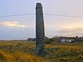
Lady's Finger
-
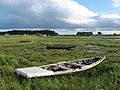
Traditional fishing boats at Mornington
-
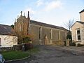
Old Star of the Sea church
