Laytown facts for kids
Quick facts for kids
Laytown
Irish: An Inse
|
|
|---|---|
|
Village
|
|

Laytown Races
|
|
| Country | Ireland |
| Province | Leinster |
| County | County Meath |
| Irish Grid Reference | O162714 |
Laytown (which in Irish is An Inse, meaning "the holm" or "island") is a village in County Meath, Ireland. It sits right on the Irish Sea coast. You can find it along the R150 regional road.
Long ago, Laytown was called Ninch. This name came from the area of land it is built on. Laytown is part of a larger group of villages. These include Mornington, Bettystown, and Donacarney. Together, they form the census town of Laytown–Bettystown–Mornington–Donacarney. In 2022, over 15,000 people lived here.
Contents
History of Laytown
People have lived in the Laytown area for about 1,500 years. Digs have shown that a settlement existed here since at least the 6th century AD.
Amazing Archaeological Finds
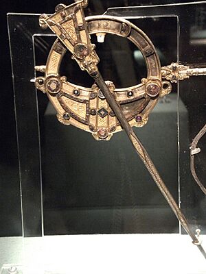
One of Ireland's most famous historical treasures was found near Laytown. In 1850, the Tara Brooch was supposedly found on Bettystown beach. It is a beautiful piece of ancient Irish art. Many people think it was actually found somewhere else. The story might have been made up to avoid legal issues. Today, you can see the Tara Brooch at the National Museum of Ireland in Dublin.

More recently, other cool things have been found. In 1976, a blue glass bead from early Christian times was discovered. It was found at a place called a rath (an old circular fort) in Ninch West. People say Laytown gets its name from Laeg mac Riangabra. He was Cuchulain's charioteer, a famous hero from Irish legends. This glass bead is also now at the National Museum of Ireland.
In the late 1970s, an old earth mound called 'The Mote' was dug up. It overlooks the River Nanny. During this dig, two Iron Age burials were found. In 2000, another dig found early Christian graves. About 50 people were buried there. They also found a Bronze Age enclosure. One item found was a Hiberno-Norse ring pin.
Laytown's Growth Over Time
Many of Laytown's bigger buildings were built in the mid-1800s. These include the train station master's house. The large homes facing the beach also date from this time. The Church of the Sacred Heart is special. Its front part is from the 1800s. But the main church building was rebuilt in the 1970s. It has a round shape and a big window. This window looks out over the Irish Sea.
Laytown used to be a small village by the coast. But in the early 2000s, it grew a lot. Many people moved here. Dublin, the capital city, was growing fast. So, people looked for homes in nearby towns like Laytown. This growth meant schools became very busy.
Laytown's Geography
Laytown is about 50 kilometers (30 miles) north of Dublin. Laytown and its neighbor, Bettystown, share a beautiful beachfront. This beach stretches from Mornington to Gormanston. Mornington is near the River Boyne, which is the border with County Louth. Gormanston is near the River Delvin, which borders County Dublin.
Laytown is located at the mouth of the River Nanny. This is a tidal estuary, where the river meets the sea. You can catch fish like mullet, trout, and eels here. But you won't find any salmon. Local stories say Saint Patrick chased all the salmon away from the river. There is a spring called St Patrick's Well near an old schoolhouse.
Education in Laytown
Laytown and Bettystown have two primary schools. These schools follow a Catholic tradition. They are Scoil Oilibhear Naofa Junior School and Scoil an Spioraid Naomh Senior School. Scoil Oilibhear Naofa is a modern school. There are plans to rebuild Scoil an Spioraid Naomh.
There are also two other schools nearby. These schools welcome children from all backgrounds. They are Le Cheile Educate Together National School and Gaelscoil an Bhradain Feasa. They teach about ethics and different religions. If parents want their children to learn about a specific religion, they arrange it after school.
A new secondary school, Coláiste na hInse, opened in 2008. It serves the East Meath area.
Getting Around Laytown
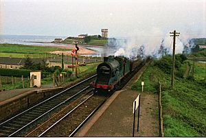
Laytown is a commuter town. This means many people who live here travel to Dublin for work. They can take the train to Dublin Connolly station. The M1 motorway also connects Laytown to Dublin. The village is on the Northern commuter train line. This line links Drogheda and Dundalk to Dublin. Laytown railway station first opened in 1844. In 1913, its name changed to Laytown & Bettystown.
An express bus service connects Laytown, Bettystown, and Sonairte to Parnell Street in Dublin. Bus Éireann also runs a local bus route, the D1. This bus provides daily services to and from Drogheda. It goes through Bettystown and Mornington.
The East Meath area also has a free monthly magazine. It is called the Meath Coaster. This magazine shows pictures of the coast. It also shares news about local schools and clubs. It gives updates from the Meath County Council.
Things to Do and See
Laytown has a local police station, called a garda station. It also has the primary school, Scoil an Spioraid Naoimh. Coláiste na hInse is the co-educational secondary school. It opened in 2008 and had over 1,000 students by 2018. The village also has three pubs, two newsagents, a pharmacy, two take-away restaurants, and a coffee shop. Of course, it has the railway station too.
Sonairte, the National Ecology Centre, is just half a mile from the station. It is on the Julianstown road (R150).
Laytown on Film
Laytown's beautiful beach has been a filming location for movies and TV shows. Both Irish and American films have been shot here. These include The Crying Game and Michael Collins. The Crying Game was filmed in Laytown in 1991. The car park was used as a fairground. The old wooden bridge over the River Nanny was also a filming spot.
Laytown Races
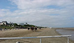
Since 1868, Laytown has hosted a special horse racing event. It happens once a year right on the beach. This is very rare in Europe. The BBC even made a documentary about it called Racing the Tide. They also featured it in their Coast and Countryfile TV shows.
In the past, horses would run along the beach, turn around, and run back. Spectators stood very close to the action. There were no barriers between them and the horses.
In 1994, a serious accident happened. One horse got scared by a small stream on the course. It ran into the crowd. This caused other horses to panic too. One jockey went to the hospital. Several people in the crowd were hurt. Sadly, three horses were so badly injured that they had to be put down.
The races stopped for a few years after that. When they started again, many new safety rules were in place. Barriers were built to keep the crowd safe. Now, people watch from a field next to the beach. The number of horses in each race is limited. Also, the races are much shorter, and horses no longer turn around during the race.
Local Government
Laytown is part of the local government area called Laytown–Bettystown. This area is looked after by the Meath County Council.
 | Frances Mary Albrier |
 | Whitney Young |
 | Muhammad Ali |


