Derrinturn facts for kids
Quick facts for kids
Derrinturn
Doire an tSoirn
|
|
|---|---|
|
Village
|
|

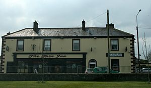
The Turn Inn, Derrinturn
|
|
| Country | Ireland |
| Province | Leinster |
| County | County Kildare |
| Area | |
| • Total | 2 km2 (0.8 sq mi) |
| Elevation | 85 m (279 ft) |
| Population
(2022)
|
1,837 |
| Time zone | UTC+0 (WET) |
| • Summer (DST) | UTC-1 (IST (WEST)) |
| Irish Grid Reference | N759266 |
Derrinturn is a village located in County Kildare, Ireland. Its Irish name, Doire an tSoirn, means "oak wood of the furnace." The village is part of the Carbury parish. It is about 60 kilometers (37 miles) away from Dublin, the capital city of Ireland.
Contents
About Derrinturn Village
Location and Roads
Derrinturn is easy to find on a map of Ireland. The main road that runs through the village is called the R403 regional road. This road helps connect Derrinturn to other places nearby.
Village Population
The number of people living in Derrinturn has grown a lot over the years. In 2022, the village had a population of 1,837 people. This is a big jump from 1961, when only 183 people lived there. The population increased by 1000% in that time!
Local Facilities
Derrinturn has important places for its community. There is one Roman Catholic church in the village. It also has a primary school named St. Conleth's (Naomh Connlaodh), where children go to learn.
Derrinturn Townland
The area around Derrinturn is known as a "townland." The Derrinturn townland covers about 132.40 hectares (which is about 327 acres). It shares its edges with several other townlands. These include Ballyhagan to the west and Ballyshannon and Coonagh to the east. Dreenan and Rathmore are to the south, while Newbury Demesne is to the north.
See also
 In Spanish: Derrinturn para niños
 | Tommie Smith |
 | Simone Manuel |
 | Shani Davis |
 | Simone Biles |
 | Alice Coachman |


