
Border Region facts for kids

The Border Region is a part of Ireland that gets its name because it's located along the Republic of Ireland–United Kingdom border. It's a way that Ireland groups areas for statistics and planning.
This region includes five Irish counties: Cavan, Donegal, Leitrim, Monaghan, and Sligo. The Border Region covers a large area of 11,516 square kilometers. That's about 16.4% of Ireland's total land!
In 2022, about 419,473 people lived here, which is about 8.14% of Ireland's population. The biggest towns in the region are Letterkenny and Sligo, both with more than 20,000 people.
Contents
Counties in the Region
The Border Region is made up of these local government areas:
Changes to the Region
In 2018, one county, County Louth, moved from the Border Region to the Mid-East Region. This changed the Border Region from 6 counties to 5.
Louth was moved because it's very close to Dublin and has strong economic connections there, even though it shares a border with Northern Ireland. When Louth left, the Border Region lost its second-largest county by population. It also lost its two biggest towns, Dundalk and Drogheda, and its connection to the Irish Sea.
Before this change, Drogheda was the closest town in the region to Dublin, only 48 km away. Now, Virginia in County Cavan is the closest, at 85 km from Dublin.
How the Region Was Managed

From 1994 to 2014, the Border Region was looked after by the Border Regional Authority. This group had 38 elected representatives from the six local councils in the region at that time. They would meet once a month to make decisions for the area.
However, these Regional Authorities were closed down in 2014. They were replaced by new groups called Regional Assemblies, which started working on January 1, 2015.
People and Culture

Just like the rest of Ireland, the Border Region's population is growing. However, it's generally one of the slower-growing regions in the country. The population growth is different depending on if you are in the east or west of the region. This is because the eastern counties are closer to Dublin.
For example, Cavan is one of Ireland's fastest-growing counties. Its population grew by 4% between 2011 and 2016. On the other hand, Donegal's population actually decreased by 1.5% during the same time.
In 2016, the Border Region had a population of 392,837 people. This was about 8.28% of Ireland's total population. The region is not very crowded, with only about 34.1 people living in each square kilometer. County Donegal is the largest county in the Border Region, both in size and population.
The Border Region is home to several important Gaeltacht areas. These are places where the Irish language is still spoken every day. Some famous Gaeltacht areas here include Gweedore, Na Rosa, and Tory Island. The type of Irish spoken here is called Ulster Irish. Donegal even has its own special version, often called "Donegal Irish." About 25% of all the people who live in Gaeltacht areas in Ireland live in Donegal.
Even with these Gaeltacht areas, the Border Region has the lowest percentage of Irish speakers compared to other regions. For example, 40% of people in Leitrim speak Irish, while in Cavan, it's 34.6%.
The region has 17 towns with more than 2,000 people. Seven of these are in Donegal, five in Cavan, three in Monaghan, and one each in Sligo and Leitrim.
Largest Towns
Here are the ten largest towns in the Border Region. County capitals are shown in bold.
| Rank | Town | County | Population (2022 census) |
|---|---|---|---|
| 1 | Letterkenny | Donegal | 22,549 |
| 2 | Sligo | Sligo | 20,608 |
| 3 | Cavan | Cavan | 11,741 |
| 4 | Monaghan | Monaghan | 7,894 |
| 5 | Buncrana | Donegal | 6,971 |
| 6 | Carrickmacross | Monaghan | 5,745 |
| 7 | Ballybofey-Stranorlar | Donegal | 5,406 |
| 8 | Carrick-on-Shannon | Leitrim & Roscommon | 4,743 |
| 9 | Castleblayney | Monaghan | 3,926 |
| 10 | Virginia | Cavan | 3,211 |


Economy

In 2016, the Border Region had the lowest economic output per person in Ireland. The economic difficulties that started in 2008 had a big impact here. For example, the money made per person dropped a lot between 2007 and 2014. While the economy is slowly getting better, it's still not as strong as it once was.
Many different types of jobs and businesses are important in the region. These include services (like shops and offices), farming, manufacturing (making things), fishing, and tourism. Services make up most of the region's economy, followed by manufacturing and construction. Farming also plays a role.
Tourism is growing in the Border Region, but it faces challenges because the roads and other facilities are not always the best. The region is mostly rural, meaning it has a lot of countryside and smaller farms compared to other parts of Ireland.
A study found that the Border Region counties were the most affected in Europe by Brexit (the UK leaving the European Union). This is because a lot of trade between Northern Ireland and the Republic of Ireland happens in this region. About 33% of the goods exported from the Border Region go to the UK.
In mid-2017, the unemployment rate in the region was 6.6%, which was a little higher than the national average for Ireland.
Geography
Land, Water, and Weather

The Border Region covers all of Ireland's northwest coast along the Atlantic Ocean. Two of Ireland's longest rivers, the Shannon and the Erne, both start in this region, in County Cavan. These two rivers have even been connected to create one of the world's longest waterways, the Shannon–Erne Waterway.
The eastern parts of the region, like Cavan and Monaghan, have a "drumlin" landscape. This means there are many small, oval hills with hundreds of lakes in between them. Lough Allen in Leitrim is the biggest lake in the region, covering 35 square kilometers.
The western part of the region, from County Cavan to the Atlantic coast, is mostly rocky and mountainous. You can find amazing coastal cliffs and beautiful sandy beaches in Sligo, Donegal, and Leitrim. Leitrim has the shortest coastline of any county, only 5 km long, while Donegal has the longest, stretching for 1,134 km.
About 11.3% of the Border Region is covered by forests and woodlands. This is similar to the national average for Ireland. In recent years, the amount of forest cover has grown quickly, especially due to privately owned forests. County Leitrim is now Ireland's most forested county, with 18.9% of its land covered by trees.
The region has a mild temperate oceanic climate. This means it has cool winters, mild and humid summers, and not many extreme temperatures. Summer daytime temperatures are usually between 15 and 22°C. While winters are generally mild, higher areas, especially in Donegal, often get snow each year. It rains throughout the year, and the region is quite humid.
Rocks and Mountains

The Border Region has many large mountain ranges and tall sea cliffs. Some famous ones include the Derryveagh Mountains, Slieve League, the Cuilcagh Mountains, and Ben Bulben.
Much of the region's ground is made of very old rocks, some laid down hundreds of millions of years ago. For example, the bedrock in western Cavan, Leitrim, and Sligo is mostly made of limestone that formed about 355 million years ago.
County Donegal has a very complex geology. Many of its rocks are incredibly old, formed about 700 million years ago. The highest point in the Border Region, Errigal, is 751 meters tall and is made of a very hard rock called quartzite.
Ireland's oldest rocks, formed 1.78 billion years ago, are found on Inishtrahull island. This island is Ireland's most northerly point, about 10 km north of Malin Head. Lough Swilly in Donegal is one of Ireland's three fjords (long, narrow inlets of the sea with steep sides). Because of its beautiful and rugged landscape, Donegal was named "Coolest place on the Planet" by National Geographic in 2017!
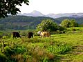
Gallery
-

Slieve League,
County Donegal -
Dromahair,
County Leitrim -

Mullaghmore,
County Sligo -

Killykeen,
County Cavan -
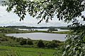
Lough Muckno,
County Monaghan


Getting Around
Air Travel

The Border Region has one airport that offers commercial flights: Donegal Airport in Carrickfinn. It serves about 45,000 passengers each year.
Many people in East Donegal also use City of Derry Airport in Northern Ireland. People near Sligo and Leitrim often use Ireland West Airport Knock, which is just outside the region in County Mayo. Sligo Airport is a smaller airport, but it doesn't have regular scheduled flights. The Irish Defence Forces also use a military landing strip in South Donegal.
Train Travel
The Border Region has the fewest train and motorway connections in Ireland. Iarnród Éireann (Irish Rail) operates a train line from Dublin to Sligo, which also stops in Carrick-on-Shannon.
Historically, there were more train lines. The Sligo, Leitrim and Northern Counties Railway was a main line in the region but closed in 1957. Donegal used to have an extensive rail network, but it closed in 1960, and now Donegal has no operational railways. Similarly, Monaghan is the only other county in the Republic of Ireland without any existing commercial or freight railway lines. The closest working train station for County Donegal is in Derry, Northern Ireland.
Road Travel
The Border Region is the only region in the Republic of Ireland that doesn't have access to the national motorway network. The M1 motorway, which runs from Dublin to Dundalk, used to serve County Louth when it was part of the Border Region.
Road links to Cavan have improved with the building of the M3. However, this motorway only goes as far as Kells in County Meath before becoming a regular dual carriageway.
The region is served by several important national primary roads:
- The N2 road connects Dublin to Monaghan and continues towards Derry in Northern Ireland.
- The N3 road links Dublin to Cavan and Ballyshannon.
- The N4 road connects Dublin to Sligo.
- The N12 road goes from Monaghan to the border with Northern Ireland, towards Belfast.
- The N13 road connects Sligo to Letterkenny and then towards Derry in Northern Ireland.
- The N14 road goes from Letterkenny to Lifford and towards Strabane in Northern Ireland.
- The N15 road connects Sligo to Donegal and Lifford, then towards Derry.
- The N16 road links Sligo to the border with Northern Ireland, towards Enniskillen and Belfast.
- The N17 road connects Galway to Collooney, near Sligo.
