
Cuilcagh facts for kids
Quick facts for kids Cuilcagh |
|
|---|---|
| Binn Chuilceach | |

Cuilcagh Mountain, viewed from Belmore Mountain
|
|
| Highest point | |
| Elevation | 665 m (2,182 ft) |
| Prominence | 570 m (1,870 ft) |
| Listing | County Top (Cavan and Fermanagh), P600, Marilyn, Hewitt |
| Naming | |
| English translation | calcareous/chalky peak |
| Language of name | Irish |
| Geography | |

Cuilcagh
Location in Northern Ireland
|
|
| Location | Fermanagh, Northern Ireland & Cavan, Republic of Ireland |
| OSI/OSNI grid | H123280 |
| Topo map | OSi Discovery 26 |
| Climbing | |
| Easiest route | Cuilcagh Boardwalk Trail (Stairway to Heaven) |
| Official name: Cuilcagh Mountain | |
| Designated: | 31 December 1998 |
| Reference #: | 968 |
Cuilcagh (which means "chalky peak" in Irish) is a mountain located right on the border. It sits between County Fermanagh in Northern Ireland and County Cavan in the Republic of Ireland.
Standing at 665 meters (2,182 feet) tall, Cuilcagh is the highest point in both of these counties. It's also one of the tallest peaks on the entire island of Ireland. What makes it special is that it's Ireland's only "cross-border county top," meaning it's the highest point for two counties that are in different countries. Interestingly, water from the mountain's southern side flows underground. It later reappears many miles away at the Shannon Pot, which is known as the starting point of the famous River Shannon. Sometimes, people call this whole area the Cuilcagh Mountains.
Contents
What's in a Name?
The name Cuilcagh comes from the Irish word Cuilceach. This word is often translated as "chalky." However, the mountain itself is mostly made of sandstone and shale, covered with bog and heather.
The top of the mountain has cliffs made from strong sandstone. The name "chalky" might refer to the limestone rocks found lower down on the northern side. Here, several streams disappear into holes in the ground. These holes are part of the amazing Marble Arch Caves system. So, the name could mean "calcareous" (meaning it contains limestone) rather than just "chalky." The mountain has also been called Slieve Cuilcagh in English, where 'Slieve' is an English version of the Irish word Sliabh, meaning "mountain."
Amazing Nature

Cuilcagh Mountain is home to one of the biggest areas of "blanket bog" in Northern Ireland. A blanket bog is a type of wetland that covers large, flat areas like a blanket. This bog is found on high ground and is surrounded by grassy areas and other mountain habitats.
The bog itself has many interesting features, like pools of water, small hills (hummocks), and flat areas. It's filled with lush green Sphagnum mosses. You can also find small shrubs and different types of grasses growing there.
The Cuilcagh area is very important for insects that live in the uplands. It's one of the best places in Ireland to find these creatures. Many types of water beetles and water bugs have been found here. Lough Atona, a lake on the mountain, is a key spot for these insect species.
Protecting Cuilcagh
The Cuilcagh Mountain Park was opened in 1998 by the local council to help protect this special place.
Ramsar Site
Cuilcagh Mountain is recognized as a Ramsar site. This means it's a wetland of international importance. It was given this special status on December 31, 1998. The site is huge, covering over 2,700 hectares (about 6,700 acres).
It's important because it's a large and mostly untouched example of a blanket bog. It's considered one of the best examples of this habitat in the United Kingdom. It also has a high-altitude lake, Lough Atona, which is very clean and low in nutrients.
The site is also special because it supports rare or endangered animals. It's a very important breeding ground in Northern Ireland for the Eurasian golden plover, a bird that is listed as endangered in Ireland. The merlin, another Irish endangered bird, also lives here. Sometimes, greater white-fronted geese visit the bog to feed.
Global Geopark
In 2001, the Cuilcagh Mountain Park joined with the popular Marble Arch Caves and the Cladagh Glen Nature Reserve. Together, they formed one of the first European Geoparks recognized by UNESCO. This became a Global Geopark in 2004.
In September 2008, the Geopark grew even bigger, expanding into County Cavan. This made it the world's first "transnational cross-border Geopark." This means it's a Geopark that crosses the border between two countries! The Geopark is looked after by the Fermanagh & Omagh District Council through the staff at the Marble Arch Caves Visitor Centre.
The Boardwalk Trail


In 2015, the Cuilcagh Boardwalk Trail was opened. It's also known as the Cuilcagh Legnabrocky Trail or famously, "The Stairway to Heaven." This wooden walkway was built to protect the delicate bog underneath from being damaged by walkers.
Before the boardwalk, about 3,000 people visited Cuilcagh each year. After it opened, the number of visitors jumped to over 60,000! The wooden trail is 7.5 kilometers (about 4.7 miles) long and is part of a longer walking route. While the trail is very popular, there are some worries about how the area can handle so many visitors.
Images for kids
-
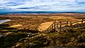
Near top of the "Stairway to Heaven", looking back down the trail
-
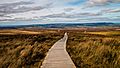
Boardwalk section of "Stairway to Heaven"
See also
 In Spanish: Binn Chuilceach para niños
