
Marble Arch Caves facts for kids
Quick facts for kids Marble Arch Caves |
|
|---|---|
| Uaimh an Áirse Mharmair | |

"The Castle" gour pool formations in the Marble Arch Caves show cave.
|
|
| Location | near Florencecourt, County Fermanagh |
| Depth | 94 m |
| Length | 11.5 km (7.1 mi) |
| Discovery | 1895 |
| Access | Show cave; accessible beyond with permission from Marble Arch Caves centre |
The Marble Arch Caves are amazing natural limestone caves. You can find them near the village of Florencecourt in County Fermanagh, Northern Ireland. The caves get their name from a nearby natural limestone arch called Marble Arch. The Cladagh River flows right under this arch!
These caves were formed by three rivers that flow down from Cuilcagh mountain. These rivers meet underground to create the Cladagh River. On the surface, this river comes out of the biggest karst spring in Ireland. It's also one of the largest in the United Kingdom.
The Marble Arch Caves are the longest known cave system in Northern Ireland. They stretch for about 11.5 kilometers (7.1 miles). The special rock formations here are considered some of the best in the British Isles.
Contents
Exploring the Marble Arch Caves
Early Discoveries (1700s-1800s)

People knew about the Marble Arch and the Cladagh River spring for a long time. Even in the 1730s, a man named Reverend William Henry wrote about them. He also knew about the places where three rivers (the Owenbrean, Aghinrawn, and Sruh Croppa) disappeared underground. He correctly guessed that these rivers fed the cave system.
Henry even went down into one of the large sinkholes (also called dolines or shakeholes) above the spring. He described seeing the river flowing gently underground.
First Explorations by Boat (1895)
The first real underground exploration happened in 1895. A French explorer named Édouard-Alfred Martel and a naturalist from Dublin, Lyster Jameson, led the way. They used a special canvas boat and lit their path with candles and bright magnesium flares.
Martel and Jameson explored about 300 meters (1,000 feet) of passages. They found the spot where the three rivers meet underground. They also drew maps and pictures of their journey. They reached places like the Grand Gallery and Pool Chamber. Today, part of their route to Pool Chamber is used by visitors in the show cave.
.jpg)
More Discoveries and Water Tracing (1907-1908)
.png)
In 1907, English cavers from the Yorkshire Ramblers' Club started exploring. They didn't have a boat, so they waded through the underground river. They reached the same places Martel and Jameson had explored.
The cavers returned in 1908 and found a new way into Pool Chamber. This new route avoided the deep water of the original entrance. They also did an experiment called dye tracing. They put a special colored dye into the Aghinrawn River where it disappeared underground. The dye later appeared at the Cladagh Glen spring. This proved that the rivers were connected underground!
They also found that one passage was very close to the Grand Gallery in Marble Arch Cave. They thought a connection between them might be possible.
Connecting Passages (1935-1938)
More exploration happened in 1935. Cavers found a high passage that led to a huge new cavern called New Chamber. Here, they found the river again, but it was too deep to go further.
In 1936, they returned and explored the Skreen Hill passage. This passage was named after the hill above it. After about 365 meters (1,200 feet) of walking, they reached a deep underground lake. This is where the path of the current show cave ends.
In 1938, they brought an inflatable boat to cross the lake. However, they soon reached a "sump," which is an underwater passage, blocking their way.
During the 1935 trip, another group found that water levels in Lower Cradle Hole Cave were low enough to see through. They confirmed that this cave was connected to the Grand Gallery in Marble Arch Cave. Two cavers even swam through to make the first full trip between the two caves!
Extending the System with Cave Diving (1966-1967)

By the 1960s, cave diving had become more advanced. This allowed explorers to go beyond the sumps that had stopped them before. In 1966, divers found a dry passage that bypassed Sump 1 in Skreen Hill. This led to a new 200-meter (656-foot) section of river passage called Skreen Hill 2.
They also found a half-mile long side passage called Legnabrocky Way. This passage includes the Giant's Hall, a huge chamber that is 60 meters (200 feet) long, 30 meters (98 feet) high, and 15 meters (49 feet) wide! Even though it only carries a small stream, Legnabrocky Way is the largest passage in Marble Arch Cave.
In 1967, divers successfully passed Sump 3, reaching Skreen Hill 3. This added another 640 meters (2,100 feet) of amazing river passage. A full map of all the Marble Arch Caves was then made.
Developing the Show Cave (1982-1985)
.jpg)
Even in 1895, Édouard-Alfred Martel thought Marble Arch Cave would be a great place for tourists. Work finally began in 1982 to turn it into a show cave. This involved a lot of construction:
- Building concrete and metal walkways with handrails.
- Installing electric lighting throughout the cave.
- Creating a new tunnel between Pool Chamber and New Chamber. This allowed visitors to walk all the way to Skreen Hill.
- Digging an access shaft and staircase from the surface down into Skreen Hill.
- Making a special path called the "Moses Walk." Here, the path sinks into the riverbed, and the water runs at shoulder level on both sides!
- Building a visitor centre, car park, and access road on the surface.
The Marble Arch Caves show cave opened to the public on May 29, 1985. Visitors start their tour with a boat ride on the underground Cladagh River. Then, they walk through the rest of the amazing chambers.
.jpg)
.jpg)
Between 1985 and 2008, about 1 million people from 100 different countries visited the show cave.
Connecting More Caves (2009-2010)
In 2009 and 2010, a diver named Artur Kozłowski made important new connections. He connected Marble Arch Caves to nearby cave systems like Prod's Pot – Cascades Rising. This doubled the total length of the system! Later, he and Chris Jewell connected it to the Monastir Sink – Upper Cradle system. These discoveries made Marble Arch Caves the longest cave in Northern Ireland, stretching to 11.5 kilometers (7.1 miles).
Marble Arch Caves Global Geopark
In 2001, the caves and the nearby Cuilcagh Mountain Park became a European Geopark. It was the first park in the UK to get this special recognition. This was because of the caves and the rare "blanket bog" (a type of wetland) on the mountains.
In 2004, the park became part of the Global Network of National Geoparks (GGN) and was renamed Marble Arch Caves Global Geopark. In 2008, the park grew even bigger! It now crosses the border into parts of County Cavan in the Republic of Ireland. This made it the first international Geopark in the world.
Protecting the Caves

Protecting the caves and the land above them is very important. One problem has been the cutting of turf (a type of soil used for fuel). This has damaged the bog's ability to hold water. When the bog can't hold water, it can lead to flooding and very high water levels in the caves. This has sometimes stopped tourist visits.
To protect the caves, turf cutting is now banned in the Geopark. Also, more than 1,200 small dams have been built across the bogland. These dams help slow down the water flow and encourage new bog to grow.
Another issue is that human actions can damage the limestone and cave formations. Before the show cave opened, some people broke in and threw stones at the beautiful calcite formations. Many small stalactites were broken. The tip of the largest stalactite in the show cave, which was over 2 meters (6.6 feet) long, was also broken off. Luckily, it was found and later glued back into place using a special resin.
Images for kids
-
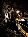
A section of cave passage and walkway in the showcave.

