River Cladagh facts for kids
Quick facts for kids Cladagh River |
|
|---|---|

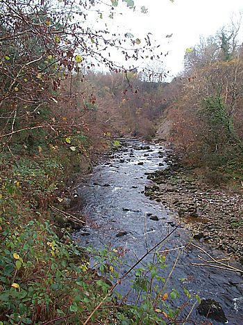
Cladagh River flowing through Cladagh Glen
|
|
| Native name | an Chlaideach |
| Country | United Kingdom |
| State | Northern Ireland |
| Region | Ulster |
| County | Co. Fermanagh |
| Physical characteristics | |
| Main source | Marble Arch Caves, Co. Fermanagh 145 m (476 ft) 54°15′36.464″N 7°48′48.744″W / 54.26012889°N 7.81354000°W |
| River mouth | Arney River 50 m (160 ft) 54°17′10.73″N 7°47′29.19″W / 54.2863139°N 7.7914417°W |
| Length | 4 km (2.5 mi) |
The Cladagh River is a small river in County Fermanagh, Northern Ireland. Its name comes from the Irish words "an Chlaideach," meaning "washing river." This river is special because it starts underground! Three smaller rivers and many streams flow off the northern side of Cuilcagh mountain. They all meet up deep inside the amazing Marble Arch Caves system.
The Cladagh River then comes out from underground. It emerges from one of the biggest "karst resurgences" in the UK. A karst resurgence is a place where an underground river comes back to the surface. After that, the river flows through the beautiful Cladagh Glen Nature Reserve. Finally, it empties into the Arney River.
Contents
Where Does the Cladagh River Flow?
The Cladagh River has a fascinating journey, both hidden underground and flowing freely above ground.
Underground Journey
The Cladagh River begins its journey as three smaller rivers. These are the Sruh Croppa, the Aghinrawn, and the Owenbrean. All three of these rivers disappear into the limestone rock on a flat area called the Marlbank. The Marlbank is a plateau on the northern part of Cuilcagh Mountain.
These rivers then join up underground. They flow together inside the huge Marble Arch Caves system. The Sruh Croppa and Aghinrawn rivers meet first. They flow a short distance from a spot called Cradle Hole into Marble Arch Cave. Then, they join the Owenbrean River at a place known as The Junction. If the water levels are normal, visitors can start a boat tour of the Marble Arch Caves. This tour begins on the first part of the Cladagh River underground. It passes The Junction before going further upstream along the Owenbrean.
Above Ground Journey
After its underground adventure, the main part of the river comes out. It pours from under a cliff face. This happens in a rocky area right above the Marble Arch. The Marble Arch is a natural bridge made of limestone. This natural arch gives its name to the entire cave system.
The Cladagh River then tumbles under this arch. It quickly turns north and flows into the start of the Cladagh River gorge. This gorge is also known as Cladagh Glen.
About halfway through Cladagh Glen, another large underground river joins the Cladagh. This happens at a spot called Cascades Rising. This water comes from another part of the Marble Arch Cave system. It collects water from a very large area. This area includes places like Gortmaconnell (2 km away) and Brookfield (2.5 km away). Surprisingly, it also gets water from Badger Pot and other sinks on East Cuilcagh, which are 5.5 km away! Some water from the Owenbrean River also joins here from smaller sinks upstream.
Natural Environment
The area around the Cladagh River is very special for nature. It is part of the Marble Arch Caves Global Geopark. A Geopark is a place with important geological features that are protected. This Geopark includes Marlbank Forest, the Cladagh Glen, and the Marble Arch National Nature Reserve. You can even walk through Cladagh Glen on a path that is part of the Ulster Way walking route.
 | Bessie Coleman |
 | Spann Watson |
 | Jill E. Brown |
 | Sherman W. White |


