
Shannon Pot facts for kids
Quick facts for kids Shannon PotLag na Sionna |
|
|---|---|
.jpg) |
|

Shannon Pot
Lag na Sionna Location in Ireland
|
|
| Location | Derrylahan townland, Glangevlin, County Cavan |
| Coordinates | 54°14′05″N 7°55′08″W / 54.23475°N 7.919°W |
| Type | pool |
| Primary inflows | Shannon Cave |
| Primary outflows | River Shannon |
| Catchment area | 12.8 km2 (4.9 sq mi) |
| Basin countries | Ireland |
| Max. length | 16 m (52 ft) |
| Max. width | 16 m (52 ft) |
| Max. depth | 14.6 m (48 ft) |
The Shannon Pot is a special pool of water found in a rocky area called a karst landscape. It's located in a place called Derrylahan, near Cuilcagh Mountain in County Cavan, Ireland.
This pool is fed by underground water, which means its water level can change naturally. It's known as the traditional starting point, or "source," of the River Shannon, which is the longest river in Ireland.
The Shannon Pot is about 16 meters (52 feet) wide. Divers have explored it down to a depth of 14.6 meters (48 feet).
Some towns and villages close to the Shannon Pot are Dowra, Blacklion, and Glangevlin.
Contents
The Shannon Pot's Story
The Shannon Pot has been known for a very long time. One of the earliest mentions of it is in a book called the Book of Magauran. A poem from around the year 1349 says that the Shannon comes from this well. It calls the Shannon the "noblest stream" in Ireland.
The Legend of Sionnan
There's a cool legend about how the River Shannon got its name. It's named after a girl called Sionnan. She was the granddaughter of Manannán mac Lir, who was the god of the sea.
Sionnan came to this spot to eat a special, forbidden fruit. This fruit came from the Tree of Knowledge, which was planted by wise people called druids. But as she started to eat the fruit, the water in the pool suddenly burst out! It completely covered her and pulled her down into the pool. The water then flowed out over the land, creating the mighty River Shannon.
Exploring the Depths
People have been curious about what's deep inside the Shannon Pot.
- In 1971, divers Roger Solari and John Elliot were the first to explore it. They went down to 6 meters (20 feet), then later to 9 meters (30 feet).
- They found that the water came out of a narrow opening, about 2 meters (6.6 feet) wide and 300 millimeters (1 foot) high.
- It was hard for them to go further because of tree branches, equipment problems, and murky, dark brown water.
- Other divers, like Martyn Farr, also explored the pot, but couldn't go much deeper for many years.
More progress was made much later, in 2008 and 2009.
- Divers Alasdair Kennedy, Paul Doig, and Artur Kozłowski explored it again.
- Artur Kozłowski managed to widen the narrow opening. He then went past a slope of loose stones and found an unstable room.
- They found a strong current of water coming from a tight, unstable shaft in the floor of this room.
- Doig and Kennedy mapped this room, reaching a depth of 14.6 meters (48 feet).
Where the Water Comes From
Scientists have studied the area around the Shannon Pot to understand where its water comes from.
- They found that an area of about 12.8 square kilometers (4.9 square miles) collects water for the pot. This is called its catchment area.
- This area includes a lake called Garvagh Lough, which is about 2.2 kilometers (1.4 miles) northeast of the pot.
- Water from Garvagh Lough flows into a sinkhole called Pollnaowen, and then it comes out at the Shannon Pot.
The highest point where water starts to flow into the pot is a spring at Tiltinbane. This spring feeds a stream that goes into Shannon Cave. Other places where water sinks into the ground and eventually reaches the pot include Pollboy, Pollahune, Polltullyard, and Tullyrrakeeragh.
Studies also suggest that the Shannon Pot might have collected water from an even bigger area in the past. When there's a lot of rain, the Shannon Pot has been shown to be connected underground to Badger Pot and Pigeon Pot. These are located about 10.6 kilometers (6.6 miles) north of the Shannon Pot, near Florencecourt Forest Park.
Images for kids
-
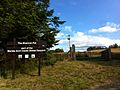
Sign at the entrance to the Shannon Pot
-
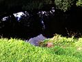
The reputed source of the River Shannon, known as 'Shannon Pot'


