Copper Coast Geopark facts for kids
The Copper Coast Geopark is a special part of the southern coast of Ireland. It stretches for about 25 kilometers (15.5 miles) in County Waterford, from Kilfarrasy in the east to Stradbally in the west. This area was the first geopark to be recognized in Ireland. It's a place where you can explore amazing rocks, learn about Earth's history, and enjoy beautiful scenery.
Contents
How the Copper Coast Was Formed
The rocks of the Copper Coast tell a story that began over 460 million years ago! Back then, huge volcanoes were active in this area. These volcanoes created many of the rocks we see today. Over millions of years, different types of rocks formed. Some came from the volcanoes, while others were made from mud and sand at the bottom of ancient seas.
Later, about 370 to 360 million years ago, more rocks formed. These were reddish-brown rocks made from pebbles, sand, and mud. They show us what the landscape was like back then. Much more recently, during the last ice age, huge glaciers moved across the land. As they melted, they left behind layers of sand, gravel, and clay. All these different layers of rock and soil help scientists understand Earth's long history.
Why It's Called the "Copper Coast"
The name "Copper Coast" comes from its exciting past. Long ago, people mined copper here. You can still see the remains of these old mines, which are now interesting places to visit.
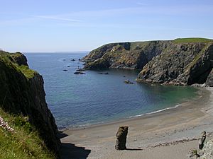
The geopark covers about 25 kilometers (15.5 miles) of coastline. It's a mostly flat area, but it has dramatic cliffs along the sea. Many small streams flow through deep valleys, leading to lovely beaches and hidden coves. You'll also see cool rock formations like sea stacks and rocky headlands.
A Rich History of People Too
Besides its amazing geology, the Copper Coast has a rich human history. You can find ancient stone tombs from the Neolithic period (New Stone Age). There are also old forts from the Iron Age, mysterious inscribed stones, and the ruins of medieval churches and a castle. All these sites show that people have lived and worked here for thousands of years.
Becoming a Geopark
The idea for the Copper Coast Geopark started around 1997 with local people who wanted to protect and share the area's unique heritage. In 2001, it became a European Geopark. Then, in 2004, it joined the UNESCO Global Geoparks Network. In 2015, it was officially named a UNESCO Global Geopark. This recognition helps protect the area for the future and also encourages more visitors to come and explore its wonders.
What You Can See and Do
The Copper Coast Geopark is a fantastic place to learn about Earth's past. It has rocks that show evidence of ancient volcanic activity and the effects of the last ice age. Local experts and guides help visitors understand these amazing stories.
The geopark has a visitor centre located at Monksland Church in Knockmahon. Here, you can find out more about the geology and history of the area. The geopark also looks after an old engine house, which is a reminder of the region's mining past.
How the Geopark Is Run
The Copper Coast Geopark is managed by a special group called a charitable company. This means it's run by people who volunteer their time, including local residents and experts in geology and heritage. They have a small team, including a part-time manager and a geologist. Many volunteer guides also help out, sharing their knowledge with visitors. People from local community programs also support the geopark's work.
 | Calvin Brent |
 | Walter T. Bailey |
 | Martha Cassell Thompson |
 | Alberta Jeannette Cassell |


