
Knockmealdown facts for kids
Quick facts for kids Knockmealdown |
|
|---|---|
| Cnoc Mhaoldomhnaigh | |

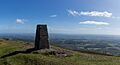
Knockmealdown east face and summit
The screes are steep and barren looking though sheep are grazing |
|
| Highest point | |
| Elevation | 792 m (2,598 ft) |
| Prominence | 683 m (2,241 ft) |
| Parent peak | Galtymore |
| Listing | County top (Waterford), P600, Marilyn, Hewitt |
| Naming | |
| English translation | hill of Maoldomhnach |
| Language of name | Irish |
| Geography | |

Knockmealdown
Location in Ireland
|
|
| Location | Waterford, Republic of Ireland |
| Parent range | Knockmealdown Mountains |
| OSI/OSNI grid | S058084 |
| Topo map | OSi Discovery 74 |
| Geology | |
| Mountain type | Medium grained pink-purple sandstone bedrock |
| Climbing | |
| Easiest route | hiking |
Knockmealdown is a tall mountain in Ireland. Its name in Irish is Cnoc Mhaoldomhnaigh, which means 'hill of Maoldomhnach'. This mountain is the highest point in the Knockmealdown Mountains range. It sits right on the border between County Tipperary and County Waterford.
Where is Knockmealdown?
Knockmealdown is the highest mountain in the Knockmealdown Mountains. The very top of the mountain is in County Waterford. It is actually the highest point in all of County Waterford! The border between County Tipperary and County Waterford often runs along the mountain ridge. This means that many of the main peaks are found in both counties.
What's in a Name?
The name Knockmealdown comes from an older Irish name. Most people believe the original Irish name was Cnoc Mhaoldomhnaigh. This means "Muldowneys' hill". Another idea is that the name comes from Cnoc Maol Donn. This would mean "bald brown hill". In 1654, the name was written as Knockmealdowny. This shows it might have had an extra sound at the end a long time ago.
Hiking Up the Mountain
Knockmealdown is a great place for hiking. It is quite easy to reach the peak from the west side. You can start near a parking area that looks over Bay Lough at the Vee Gap. From there, you first climb Sugarloaf Hill.
Another way to climb the mountain is to follow the Glannandaree stream. You can find a car park where the R668 and R669 roads meet. This path will lead you up the mountain.
Images for kids
-
The summit of Knockmealdown mountain

See also
 In Spanish: Cnoc Mhaoldomhnaigh para niños
