Sugarloaf Hill (Knockmealdowns) facts for kids
Quick facts for kids Sugarloaf Hill |
|
|---|---|
| Cnoc na Binne | |

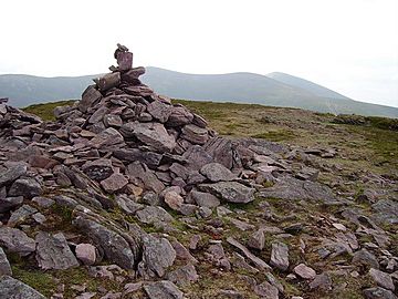
Summit cairn of Sugarloaf Hill
|
|
| Highest point | |
| Elevation | 663 m (2,175 ft) |
| Prominence | 118 m (387 ft) |
| Listing | Hewitt |
| Geography | |
|
Lua error in Module:Location_map at line 420: attempt to index field 'wikibase' (a nil value).
|
|
| Location | County Tipperary / County Waterford, Ireland |
| Parent range | Knockmealdown Mountains |
| OSI/OSNI grid | S039105 |
| Topo map | OSi Discovery 74 |
Sugarloaf Hill (which is called Cnoc na Binne in Irish) is a mountain peak. It stands tall in the Knockmealdown Mountains. This mountain is special because it sits right on the border between two counties in Ireland: County Tipperary and County Waterford.
Contents
Discover Sugarloaf Hill
Sugarloaf Hill is a well-known mountain in Ireland. It reaches a height of 663 meters (about 2,175 feet) above sea level. This makes it a significant peak in its area. It is also known as a "Hewitt," which is a special term for hills in Ireland, England, and Wales that are over 2,000 feet high and have a certain prominence.
Where is Sugarloaf Hill?
This mountain is located in the southern part of Ireland. It acts like a natural boundary between County Tipperary to the north and County Waterford to the south. The Knockmealdown Mountains stretch across these two counties. Sugarloaf Hill is one of the many beautiful peaks you can find there. Its exact spot can be found using grid references, which are like coordinates on a map.
What Makes it Special?
Sugarloaf Hill is part of the larger Knockmealdown Mountains range. These mountains are known for their rounded tops and green slopes. They are a popular place for hiking and enjoying nature. Even though Sugarloaf Hill is not the highest peak in Ireland, it offers great views of the surrounding countryside. From its summit, you can see far across the counties of Tipperary and Waterford.
The Knockmealdown Mountains
The Knockmealdown Mountains are a range of hills that run from east to west. They are mostly made of sandstone and shale. These mountains were formed millions of years ago. They have been shaped by ice and weather over time. The highest point in the Knockmealdown range is Knockmealdown, which is taller than Sugarloaf Hill. The area is generally quiet and peaceful, making it a lovely spot for outdoor activities.
Nature Around Sugarloaf Hill
The slopes of Sugarloaf Hill and the surrounding Knockmealdown Mountains are home to various plants and animals. You might find different types of grasses, heather, and ferns growing there. These plants are adapted to the mountain environment.
Animals and Plants Life
Many small animals live in these mountains. You might spot birds like the skylark or meadow pipit. Sometimes, you can see larger animals like deer. The area is also important for insects and other small creatures. They all play a part in the mountain's ecosystem. The plants provide food and shelter for these animals.
Exploring the Mountain
Hiking up Sugarloaf Hill can be a rewarding experience. The paths might be steep in places, but they are generally manageable. Hikers often reach the summit to enjoy the panoramic views. It's important to be prepared for different weather conditions when visiting any mountain. The weather can change quickly in Ireland.
Safety Tips for Hikers
If you plan to visit Sugarloaf Hill, always tell someone where you are going. Wear appropriate clothing and sturdy shoes. Carry enough water and some snacks. It's also a good idea to bring a map and compass, or a GPS device. Always follow the marked trails to stay safe and protect the natural environment.
 | Chris Smalls |
 | Fred Hampton |
 | Ralph Abernathy |

