
Flemington, New Jersey facts for kids
Quick facts for kids
Flemington, New Jersey
|
|
|---|---|
|
Borough
|
|
| Borough of Flemington | |

Flemington from Prospect Hill, looking southeast
|
|

Location of Flemington within Hunterdon County. Inset: Location of Hunterdon County highlighted in the State of New Jersey.
|
|

Census Bureau map of Flemington, New Jersey
|
|

Flemington, New Jersey
Location in Hunterdon County, New Jersey

Flemington, New Jersey
Location in New Jersey

Flemington, New Jersey
Location in the United States
|
|
| Country | |
| State | |
| County | |
| Incorporated | April 26, 1910 |
| Named for | Samuel Fleming |
| Government | |
| • Type | Borough |
| • Body | Borough Council |
| Area | |
| • Total | 1.08 sq mi (2.79 km2) |
| • Land | 1.08 sq mi (2.79 km2) |
| • Water | 0.00 sq mi (0.00 km2) 0.00% |
| Area rank | 494th of 565 in state 22nd of 26 in county |
| Elevation | 180 ft (50 m) |
| Population | |
| • Total | 4,581 |
| • Estimate
(2019)
|
4,577 |
| • Rank | 392nd of 566 in state 9th of 26 in county |
| • Density | 4,252.2/sq mi (1,641.8/km2) |
| • Density rank | 141st of 566 in state 1st of 26 in county |
| Time zone | UTC−05:00 (Eastern (EST)) |
| • Summer (DST) | UTC−04:00 (Eastern (EDT)) |
| ZIP Code |
08822
|
| Area code(s) | 908 |
| FIPS code | 3401923700 |
| GNIS feature ID | 885220 |
Flemington is a borough in Hunterdon County, New Jersey, United States. It is the county seat of Hunterdon County. As of the 2010 United States Census, the borough's population was 4,581, reflecting an increase of 381 (+9.1%) from the 4,200 counted in the 2000 Census, which had in turn increased by 153 (+3.8%) from the 4,047 counted in the 1990 Census. Most of the borough is located in the Amwell Valley (a low-lying area of the Newark Basin) and the Raritan Valley (the South Branch of the Raritan River flows through the center of the borough). Northwestern portions of the borough sit on the Hunterdon Plateau.
Flemington is an independent municipality completely surrounded by Raritan Township and is located near the geographic center of the township.
Contents
History

Before European settlement, the land that comprises Flemington, as was all of Hunterdon County, was the territory of the Lenni Lenape Native Americans. In 1712, as part of a land parcel of 9,170 acres (37.1 km2), the Flemington area was acquired by William Penn and Daniel Coxe.
The surrounding fertile farmland dictated that the beginnings of Flemington were agricultural. Early German and English settlers engaged in industries dependent on farm products. As time passed poultry and dairy farms superseded crops in agricultural importance. An example of early settlement families was Johann David and Anna Maria Ephland, who emigrated in 1709 from Germany through London to New York and settled on his 147.5-acre (0.597 km2) farm in 1717. They raised their seven children, and two from his previous marriage, on the farm that now makes up the core of Flemington.
In 1785, Flemington was chosen as the County Seat of Hunterdon. Fire destroyed the old courthouse in 1826 and the City of Lambertville made an ultimately unsuccessful attempt to have the seat relocated there. Flemington remained the County Seat and the Courthouse which stands today on Main Street was built.
What is now Flemington was originally formed as a town by an act of the New Jersey Legislature on March 14, 1870, within portions of Raritan Township. It became a village as of June 11, 1894, still within Raritan Township. Flemington was finally incorporated as an independent borough by an act of the New Jersey Legislature on April 7, 1910, based on the results of a referendum held on April 26, 1910, and was formally separated from Raritan Township. The borough's incorporation was confirmed on April 27, 1931. the borough was named for Samuel Fleming.
In 1856, the Hunterdon County Agricultural society purchased 40 acres (16 ha) of land that would accommodate the people, exhibits and livestock for the County (Flemington) Fair. The purpose of this Fair was to promote competition between farmers, stock raisers and machinery manufacturers. The fair was held every year at the Flemington Fairgrounds which also was the site of Flemington Fair Speedway (later Flemington Raceway). From 1992 through 1995, the speedway hosted the Race of Champions, a race for modified racers. The speedway hosted a NASCAR Craftsman Truck Series race from 1995 to 1998. In 2003, the County Fair adopted a new name, The Hunterdon County 4-H and Agricultural Fair, and moved to the South County Park in East Amwell Township.
Historic landmarks
By 1980, 65% of Flemington borough had been included on the New Jersey Register of Historic Places and is now on the National Register of Historic Places.
- Union Hotel - Early 19th century hotel in downtown Flemington that served as a restaurant until its 2008 closure. The current structure dates to 1877, built on the site of what had been a stagecoach stop that dates to 1814.
- Hunterdon County Courthouse - Historic court house where the Lindbergh Trial took place. Now used for County offices.
- Fleming Castle / Samuel Fleming House - First house in Flemington, 5 Bonnell Street. Purchased by the Borough of Flemington in 2005 and operated as a historical museum by the Friends of Fleming Castle.
Geography
According to the United States Census Bureau, the borough had a total area of 1.077 square miles (2.790 km2), all of which was land.
Flemington is completely surrounded by Raritan Township, making it part one of 21 pairs of "doughnut towns" in the state, where one municipality entirely surrounds another.
Climate
| Climate data for Flemington, New Jersey (1981-2010 normals) | |||||||||||||
|---|---|---|---|---|---|---|---|---|---|---|---|---|---|
| Month | Jan | Feb | Mar | Apr | May | Jun | Jul | Aug | Sep | Oct | Nov | Dec | Year |
| Record high °F (°C) | 74 (23) |
77 (25) |
88 (31) |
95 (35) |
99 (37) |
102 (39) |
106 (41) |
108 (42) |
105 (41) |
97 (36) |
84 (29) |
75 (24) |
108 (42) |
| Average high °F (°C) | 38 (3) |
41 (5) |
50 (10) |
62 (17) |
73 (23) |
81 (27) |
86 (30) |
84 (29) |
77 (25) |
65 (18) |
54 (12) |
42 (6) |
63 (17) |
| Average low °F (°C) | 20 (−7) |
22 (−6) |
29 (−2) |
38 (3) |
48 (9) |
57 (14) |
62 (17) |
61 (16) |
53 (12) |
41 (5) |
33 (1) |
25 (−4) |
41.0 (5.0) |
| Record low °F (°C) | −18 (−28) |
−16 (−27) |
−6 (−21) |
10 (−12) |
25 (−4) |
34 (1) |
41 (5) |
37 (3) |
27 (−3) |
18 (−8) |
2 (−17) |
−14 (−26) |
−18 (−28) |
| Average precipitation inches (mm) | 3.78 (96) |
3.02 (77) |
4.37 (111) |
4.23 (107) |
4.63 (118) |
4.65 (118) |
4.94 (125) |
3.68 (93) |
4.43 (113) |
4.49 (114) |
3.77 (96) |
4.37 (111) |
50.36 (1,279) |
| Average snowfall inches (cm) | 8.9 (23) |
9.4 (24) |
4.7 (12) |
1.2 (3.0) |
0 (0) |
0 (0) |
0 (0) |
0 (0) |
0 (0) |
0 (0) |
.4 (1.0) |
5.1 (13) |
29.7 (75) |
| Average precipitation days (≥ 0.01 in) | 10.0 | 8.5 | 10.3 | 11.2 | 11.7 | 11.1 | 9.9 | 9.5 | 8.0 | 8.5 | 9.2 | 10.0 | 117.9 |
| Average snowy days (≥ 0.1 in) | 4.1 | 3.1 | 2.3 | .4 | 0 | 0 | 0 | 0 | 0 | 0 | .3 | 2.3 | 12.5 |
| Source: NOAA | |||||||||||||
Demographics
| Historical population | |||
|---|---|---|---|
| Census | Pop. | %± | |
| 1860 | 1,174 | — | |
| 1870 | 1,412 | 20.3% | |
| 1880 | 1,751 | 24.0% | |
| 1890 | 1,977 | 12.9% | |
| 1900 | 2,145 | 8.5% | |
| 1910 | 2,693 | 25.5% | |
| 1920 | 2,590 | −3.8% | |
| 1930 | 2,729 | 5.4% | |
| 1940 | 2,617 | −4.1% | |
| 1950 | 3,058 | 16.9% | |
| 1960 | 3,232 | 5.7% | |
| 1970 | 3,917 | 21.2% | |
| 1980 | 4,132 | 5.5% | |
| 1990 | 4,047 | −2.1% | |
| 2000 | 4,200 | 3.8% | |
| 2010 | 4,581 | 9.1% | |
| 2019 (est.) | 4,577 | −0.1% | |
| Population sources: 1860-1920 1870 1880-1890 1890-1910 1910-1930 1930-1990 2000 2010 |
|||
Census 2010
As of the census of 2010, there were 4,581 people, 1,815 households, and 996 families residing in the borough. The population density was 4,252.2 per square mile (1,641.8/km2). There were 1,926 housing units at an average density of 1,787.8 per square mile (690.3/km2)*. The racial makeup of the borough was 78.48% (3,595) White, 3.93% (180) Black or African American, 0.31% (14) Native American, 5.81% (266) Asian, 0.02% (1) Pacific Islander, 8.71% (399) from other races, and 2.75% (126) from two or more races. [[Hispanic (U.S. Census)|Hispanic or Latino of any race were 26.15% (1,198) of the population.
There were 1,815 households out of which 28.5% had children under the age of 18 living with them, 37.6% were married couples living together, 11.5% had a female householder with no husband present, and 45.1% were non-families. 37.1% of all households were made up of individuals, and 12.5% had someone living alone who was 65 years of age or older. The average household size was 2.44 and the average family size was 3.20.
In the borough, the population was spread out with 22.3% under the age of 18, 9.1% from 18 to 24, 33.9% from 25 to 44, 24.3% from 45 to 64, and 10.3% who were 65 years of age or older. The median age was 35.3 years. For every 100 females there were 105.5 males. For every 100 females ages 18 and old there were 106.9 males.
The Census Bureau's 2006-2010 American Community Survey showed that (in 2010 inflation-adjusted dollars) median household income was $54,261 (with a margin of error of +/- $15,065) and the median family income was $66,042 (+/- $12,761). Males had a median income of $45,934 (+/- $5,574) versus $47,917 (+/- $11,616) for females. The per capita income for the borough was $31,407 (+/- $3,648). About 14.0% of families and 16.1% of the population were below the poverty line, including 30.0% of those under age 18 and 8.9% of those age 65 or over.
Census 2000
As of the 2000 United States Census there were 4,202 people, 1,804 households, and 997 families residing in the borough. The population density was 3,927.4 people per square mile (1,515.5/km2). There were 1,876 housing units at an average density of 1,754.2 per square mile (676.9/km2). The racial makeup of the borough was 89.71% White, 1.19% African American, 0.31% Native American, 3.12% Asian, 0.17% Pacific Islander, 3.14% from other races, and 2.36% from two or more races. Hispanic or Latino of any race were 10.98% of the population.
There were 1,804 households, out of which 26.8% had children under the age of 18 living with them, 38.7% were married couples living together, 11.7% had a female householder with no husband present, and 44.7% were non-families. 37.7% of all households were made up of individuals, and 12.1% had someone living alone who was 65 years of age or older. The average household size was 2.26 and the average family size was 3.00.
In the borough the population was spread out, with 22.2% under the age of 18, 8.6% from 18 to 24, 36.9% from 25 to 44, 20.2% from 45 to 64, and 12.1% who were 65 years of age or older. The median age was 35 years. For every 100 females, there were 94.3 males. For every 100 females age 18 and over, there were 92.7 males.
The median income for a household in the borough was $39,886, and the median income for a family was $51,582. Males had a median income of $38,594 versus $31,250 for females. The per capita income for the borough was $23,769. About 5.0% of families and 6.9% of the population were below the poverty line, including 7.5% of those under age 18 and 3.0% of those age 65 or over.
Transportation

Roads and highways
As of May 2010[update], the borough had a total of 13.85 miles (22.29 km) of roadways, of which 12.09 miles (19.46 km) were maintained by the municipality, 0.17 miles (0.27 km) by Hunterdon County and 1.59 miles (2.56 km) by the New Jersey Department of Transportation.
Major roads that pass through the borough include U.S. Route 202, New Jersey Route 31 and New Jersey Route 12.

Flemington Circle is the largest of three traffic circles in the Flemington area and sits just to the southeast of Flemington's historic downtown. U.S. Route 202 and New Jersey Route 31 approach the circle separately from the north and continue south concurrently, and the circle is the eastern terminus of New Jersey Route 12. It is one of only a rapidly diminishing number of New Jersey's once-widespread traffic circles still extant according to its original design. The circle sees significant congestion on weekends because of the new developments and big-box retailers. The circle also sees a higher rate of traffic accidents and violations than any other region of Flemington and Raritan Township. Unlike most circles, traffic on US 202 does not yield on entry; US 202, being a main four-lane divided highway, gets the right of way.
One other traffic circle exists on Route 12 at Mine Street west of the Flemington Circle; Route 12 traffic has the right of way in it. The intersection of Route 12 and Main Street west of the Flemington Circle was converted to a roundabout in 2009.
Public transportation
Trans-Bridge Lines provides frequent daily bus service, west to Doylestown / Bethlehem, Pennsylvania and east to Newark Liberty International Airport, the Port Authority Bus Terminal in Midtown Manhattan and John F. Kennedy International Airport. Round-trip tickets to the PABT cost $15.
The Hunterdon County LINK provide local bus service on Routes 16 / 19 / 21 which operate to / from Raritan Township, Route 23 to / from Bridgewater Commons Mall and Somerville; Route 15 to Hampton; Route 14 to / from Lambertville; and Route 17 / 18 between Milford and Clinton.
Education
Students in public school for pre-kindergarten through eighth grade attend the Flemington-Raritan Regional School District, which also serves children from the neighboring community of Raritan Township. As of the 2018–19 school year, the district, comprised of six schools, had an enrollment of 3,079 students and 327.8 classroom teachers (on an FTE basis), for a student–teacher ratio of 9.4:1. The district consists of four K - 4 elementary schools, one intermediate school for grades 5 and 6 and a middle school for grades 7 and 8. Schools in the district (with 2018–19 enrollment data from the National Center for Education Statistics) are Barley Sheaf School (350 students; in grades K-4, located in Flemington), Copper Hill School (413; PreK-4, Ringoes), Francis A. Desmares School (447; K-4, Flemington), Robert Hunter School (388; K-4, Flemington), Reading-Fleming Intermediate School (682; 5-6, Flemington) and J. P. Case Middle School (781; 7-8, Flemington). Flemington is allocated two of the nine seats on the regional district's board of education.
Public school students in ninth through twelfth grades attend Hunterdon Central Regional High School, part of the Hunterdon Central Regional High School District, which serves students in central Hunterdon County from Flemington and from Delaware Township, East Amwell Township, Raritan Township and Readington Township. As of the 2018–19 school year, the high school had an enrollment of 2,844 students and 238.8 classroom teachers (on an FTE basis), for a student–teacher ratio of 11.9:1. Seats on the high school district's nine-member board of education are allocated based in the population of the five constituent municipalities who participate in the school district, with one seat allocated to Flemington.
Eighth grade students from all of Hunterdon County are eligible to apply to attend the high school programs offered by the Hunterdon County Vocational School District, a county-wide vocational school district that offers career and technical education at its campuses in Raritan Township and at programs sited at local high schools, with no tuition charged to students for attendance.
Notable people
People who were born in, residents of, or otherwise closely associated with Flemington include:
- Aruna (born 1975), electronic music vocalist
- Brad Benson (born 1955), offensive lineman who played for the New York Giants
- John T. Bird (1829–1911), represented New Jersey's 3rd congressional district from 1869 to 1873
- Samuel L. Bodine (1900–1958), President of the New Jersey Senate and chairman of the New Jersey Republican State Committee who served as mayor of Flemington from 1928 to 1936
- Jason Cabinda (born 1996), linebacker for the Oakland Raiders
- Marjorie Hulsizer Copher (1892-1935), dietitian who served in World War I
- Jack Cust (born 1979), professional baseball designated hitter and outfielder
- Arthur Fauset (1899–1983), civil rights activist, folklorist, and educator
- Danny Federici (1950–2008), organ and keyboard player for the E Street Band
- Arthur F. Foran (1882–1961), President of the New Jersey Senate
- Dick Foran (1910–1979), a B-movie actor who appeared in several films, most notably with the comedy team of Abbott & Costello
- Walter E. Foran (1919–1986), member of the New Jersey General Assembly and New Jersey Senate
- Kimi Goetz (born 1994), speed skater who represented the United States at the 2022 Winter Olympics
- John A. Hanna (1762–1805), U.S. representative from Pennsylvania
- Rachna Korhonen, diplomat
- John Patterson Bryan Maxwell (1804–1845), U.S. representative from New Jersey (1837–39, 1841–43)
- Barbara McClintock (born 1955), children's book author and illustrator
- Kathryn Minner (1892–1969), character actress best known as the Little Old Lady from Pasadena in a series of television commercials for Dodge which aired in Southern California from 1964 to 1969
- Charlie Morton (born 1983), Major League Baseball pitcher who has played for the Atlanta Braves, Pittsburgh Pirates and Tampa Bay Rays
- William E. Purcell (1856–1928), United States senator from North Dakota
- Richard Rubin (born 1983), television personality who appeared on the first season of Beauty and the Geek
- Brian Snyder (born 1958), MLB pitcher who played for the Seattle Mariners and Oakland Athletics
- Brian White (born 1996), footballer who plays as a forward for the New York Red Bulls in Major League Soccer
Images for kids
-
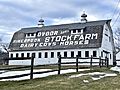
The historic Dvoor Farm is currently the headquarters for the county-wide Hunterdon Land Trust

See also
 In Spanish: Flemington (Nueva Jersey) para niños
