
Ganges facts for kids
Quick facts for kids Ganges |
|
| River | |
 The Ganges in Haridwar
|
|
| Countries | India, Bangladesh |
|---|---|
| States | Uttarakhand, Uttar Pradesh, Bihar, Jharkhand, West Bengal |
| Tributaries | |
| - left | Mahakhali, Karnali, Koshi, Gandak, Ghaghra |
| - right | Yamuna, Son, Mahananda |
| Cities | Haridwar, Kanpur, Allahabad, Varanasi, Ghazipur, Patna, Kolkata |
| Source | Gangotri Glacier |
| - location | Uttarakhand, India |
| - elevation | 3,892 m (12,769 ft) |
| - coordinates | 30°59′N 78°55′E / 30.983°N 78.917°E |
| Mouth | Ganges Delta |
| - location | Bay of Bengal, Bangladesh & India |
| - elevation | 0 m (0 ft) |
| - coordinates | 22°05′N 90°50′E / 22.083°N 90.833°E |
| Length | 2,510 km (1,560 mi) |
| Basin | 907,000 km² (350,195 sq mi) |
| Discharge | mouth |
| - average | 12,015 m³/s (424,306 cu ft/s) |
The Ganges is the second largest river on the Indian subcontinent by discharge. Ganges river is named after a Hindu goddess called Ganga. Geographists to Historians and Mythologists regard Ganges as the heart of Indian culture, tradition and living.
Contents
Geography
The government declared that the Ganges river between Allahabad and Haldia is National-Waterway No.1. The river has many industrial towns like Patliputra, Kannauj, Kara, Allahabad, Murshidabad, Baharampur and Kolkata on its banks. The Ganges Basin drains 1,000,000-square-kilometre (390,000 sq mi) and supports one of the world's highest densities of humans. The average depth of the river is 52 feet (17 m), and the maximum depth, 100 feet (33 m).
Course
The river starts from a glacier called Gangotri Glacier, which is in the Garhwal region in Himalayas. The Ganges flows through north India, and ends at the Bay of Bengal in eastern India. Overall it flows 3,877 km making it one of the longest rivers in the world. Its watershed is 907,000 km² broad. The major rivers which flow into the Ganges are Brahmaputra River, Gomti, Kosi river, Gandak, Ghaghra river, Yamuna river and Son river.

The Ganges flows only 200 km through the Himalayas. The river touches plain land in the Rishikesh region near Haridwar in Uttarakhand. Then it passes through the towns of Kanpur, Soron, Kannauj, Allahabad, Varanasi, Patna, Ghazipur, Bhagalpur, Mirzapur, Ballia, Buxar, Saidpur, and Chunar. At Allahabad, the river joins with Yamuna river. At Pakur, the river divides itself into two distributaries, viz.- the Bhāgirathi-Hooghly and the main stream. Bhāgirathi-Hooghly in the later course forms the Hooghly River. The main stream Ganges enters Bangladesh. Near the border with Bangladesh the Farakka Barrage controls the flow of the Ganges by diverting some of the water into a feeder canal which has link with the Hooghly river to keep it relatively silt-free.
History
During the early Vedic Age, the Indus and the Sarasvati River were the major rivers of the Indian subcontinent, not the Ganges. But the later three Vedas seem to give much more importance to the Ganges, as shown by its numerous references. Possibly the first European Traveler to mention the Ganges was Megasthenes (ca. 350 – 290 BCE). In Rome's Piazza Navona, Fontana dei Quattro Fiumi (fountain of the four rivers) was designed by Gian Lorenzo Bernini and built in 1651. The art-work symbolizes four of the world's great rivers (the Ganges, the Nile, the Danube, and the Río de la Plata), which is to represent the four continents (Australia and Antarctica were unknown then).
Religious Significance
In Hinduism
Hindus regard the Ganges as not only a river but also a mother, a goddess, a tradition, a culture, and much more. In Hinduism it is considered holy to take a pilgrimage to the Ganges and take a dip. This leads to more illness: adding to the death toll. Many Hindus believe that bathing in the Ganga can purify a person's soul of all past sins, and some believe that it can also cure illnesses. So, many Hindu families keep Ganga water in their homes as they consider it to be very pure. The holy towns like Haridwar, Allahabad, Kanpur, and Varanasi attract thousands of pilgrims. Thousands of Hindu pilgrims arrive at these towns to bathe in the Ganges.

Legend of Bhagirath
According to Hindu Puranas a king named Bhagiratha did Tapasya for many years to bring the River Ganges. Ganges was then residing in the Heavens. By the help of pure Ganga waters, Bhagirath wanted to release his ancestors of a curse. Therefore, the Ganges descended to the Earth to make the earth pious, fertile and wash out the sins of humans.
Irrigation
The Ganges and its all tributaries, especially the Yamuna, have been used for irrigation since ancient times. Dams and canals were common in gangetic plain by fourth century BCE. The Ganges-Brahmaputra-Meghna basin has a huge hydroelectric potential, on the order of 200,000 to 250,000 megawatts, nearly half of which could be easily harnessed. As of 1999, India tapped about 12% of the hydroelectric potential of the Ganges and just 1% of the vast potential of the Brahmaputra.
Canals

Megasthenes, a Greek ethnographer who visited India during third century BCE when Mauryans ruled India described the existence of canals in the gangetic plain. Kautilya (also known as Chanakya), an advisor to Chandragupta Maurya, the founder of Maurya Empire, included the destruction of dams and levees as a strategy during war. Firuz Shah Tughlaq had many canals built, the longest of which, 240 km (150 mi), was built in 1356 on the Yamuna River. Now known as the Western Yamuna Canal, it has fallen into disrepair and been restored several times. The Mughal emperor Shah Jahan built an irrigation canal on the Yamuna River in the early 17th century. It fell into disuse until 1830, when it was reopened as the Eastern Yamuna Canal, under British control. The reopened canal became a model for the Upper Ganges Canal and all following canal projects.

The first British canal in India—with no Indian antecedents—was the Ganges Canal built between 1842 and 1854. Contemplated first by Col. John Russell Colvin in 1836, it did not at first elicit much enthusiasm from its eventual architect Sir Proby Thomas Cautley, who balked at idea of cutting a canal through extensive low-lying land in order to reach the drier upland destination. However, after the Agra famine of 1837–38, during which the East India Company's administration spent Rs. 2,300,000 on famine relief, the idea of a canal became more attractive to the Company's budget-conscious Court of Directors. In 1839, the Governor General of India, Lord Auckland, with the Court's assent, granted funds to Cautley for a full survey of the swath of land that underlay and fringed the projected course of the canal. The Court of Directors, moreover, considerably enlarged the scope of the projected canal, which, in consequence of the severity and geographical extent of the famine, they now deemed to be the entire Doab region.
The enthusiasm, however, proved to be short lived. Auckland's successor as Governor General, Lord Ellenborough, appeared less receptive to large-scale public works, and for the duration of his tenure, withheld major funds for the project. Only in 1844, when a new Governor-General, Lord Hardinge, was appointed, did official enthusiasm and funds return to the Ganges canal project. Although the intervening impasse had seemingly affected Cautley's health and required him to return to Britain in 1845 for recuperation, his European sojourn gave him an opportunity to study contemporary hydraulic works in the United Kingdom and Italy. By the time of his return to India even more supportive men were at the helm, both in the North-Western Provinces, with James Thomason as Lt. Governor, and in British India with Lord Dalhousie as Governor-General. Canal construction, under Cautley's supervision, now went into full swing. A 560 km (350 mi) long canal, with another 480 km (300 mi) of branch lines, eventually stretched between the headworks in Hardwar, splitting into two branches below Aligarh, and its two confluences with the Yamuna (Jumna in map) mainstem in Etawah and the Ganges in Kanpur (Cawnpore in map). The Ganges Canal, which required a total capital outlay of £2.15 million, was officially opened in 1854 by Lord Dalhousie. According to historian Ian Stone:
It was the largest canal ever attempted in the world, five times greater in its length than all the main irrigation lines of Lombardy and Egypt put together, and longer by a third than even the largest USA navigation canal, the Pennsylvania Canal.
Dams and barrages
A major barrage at Farakka was opened on 21 April 1975, It is located close to the point where the main flow of the river enters Bangladesh, and the tributary Hooghly (also known as Bhagirathi) continues in West Bengal past Kolkata. This barrage, which feeds the Hooghly branch of the river by a 42 km (26 mi) long feeder canal, and its water flow management has been a long-lingering source of dispute with Bangladesh. Indo-Bangladesh Ganges Water Treaty signed in December 1996 addressed some of the water sharing issues between India and Bangladesh.
Tehri Dam was constructed on Bhagirathi River, tributary of the Ganges. It is located 1.5 km downstream of Ganesh Prayag, the place where Bhilangana meets Bhagirathi. Bhagirathi is called Ganges after Devprayag. Construction of the dam in an earthquake prone area was controversial.
Bansagar Dam was built on the Son River, a tributary of the Ganges for both irrigation and hydroelectric power generation.
Economy

The Ganges Basin with its fertile soil is instrumental to the agricultural economies of India and Bangladesh. The Ganges and its tributaries provide a perennial source of irrigation to a large area. Chief crops cultivated in the area include rice, sugarcane, lentils, oil seeds, potatoes, and wheat. Along the banks of the river, the presence of swamps and lakes provide a rich growing area for crops such as legumes, chillies, mustard, sesame, sugarcane, and jute. There are also many fishing opportunities along the river, though it remains highly polluted. Also the major industrial towns of Unnao, Kanpur, situated on the banks of the river with the predominance of tanning industries add to the pollution.
Tourism
Tourism is another related activity. Three towns holy to Hinduism—Haridwar, Prayag (Allahabad), and Varanasi—attract thousands of pilgrims to its waters to take a dip in the Ganges, which is believed to cleanse oneself of sins and help attain salvation. The rapids of the Ganges also are popular for river rafting, attracting adventure seekers in the summer months. Also, several cities such as Kanpur, Kolkata and Patna have developed riverfront walkways along the banks to attract tourists.
Ecology and environment

Human development, mostly agriculture, has replaced nearly all of the original natural vegetation of the Ganges basin. More than 95% of the upper Gangetic Plain has been degraded or converted to agriculture or urban areas. Only one large block of relatively intact habitat remains, running along the Himalayan foothills and including Rajaji National Park, Jim Corbett National Park, and Dudhwa National Park. As recently as the 16th and 17th centuries the upper Gangetic Plain harboured impressive populations of wild Asian elephants (Elephas maximus), Bengal tigers (Panthera t. tigris), Indian rhinoceros (Rhinoceros unicornis), gaurs (Bos gaurus), barasinghas (Rucervus duvaucelii), sloth bears (Melursus ursinus) and Indian lions (Panthera leo persica). In the 21st century there are few large wild animals, mostly deer, wild boars, wildcats, and small numbers of Indian wolves, golden jackals, and red and Bengal foxes. Bengal tigers survive only in the Sundarbans area of the Ganges Delta. The Sundarbands freshwater swamp ecoregion, however, is nearly extinct. Threatened mammals in the upper Gangetic Plain include the tiger, elephant, sloth bear, and four-horned antelope (Tetracerus quadricornis).

Many types of birds are found throughout the basin, such as myna, Psittacula parakeets, crows, kites, partridges, and fowls. Ducks and snipes migrate across the Himalayas during the winter, attracted in large numbers to wetland areas. There are no endemic birds in the upper Gangetic Plain. The great Indian bustard (Ardeotis nigriceps) and lesser florican (Sypheotides indicus) are considered globally threatened.
The natural forest of the upper Gangetic Plain has been so thoroughly eliminated it is difficult to assign a natural vegetation type with certainty. There are a few small patches of forest left, and they suggest that much of the upper plains may have supported a tropical moist deciduous forest with sal (Shorea robusta) as a climax species.
A similar situation is found in the lower Gangetic Plain, which includes the lower Brahmaputra River. The lower plains contain more open forests, which tend to be dominated by Bombax ceiba in association with Albizzia procera, Duabanga grandiflora, and Sterculia vilosa. There are early seral forest communities that would eventually become dominated by the climax species sal (Shorea robusta), if forest succession was allowed to proceed. In most places forests fail to reach climax conditions due to human causes. The forests of the lower Gangetic Plain, despite thousands of years of human settlement, remained largely intact until the early 20th century. Today only about 3% of the ecoregion is under natural forest and only one large block, south of Varanasi, remains. There are over forty protected areas in the ecoregion, but over half of these are less than 100 square kilometres (39 sq mi). The fauna of the lower Gangetic Plain is similar to the upper plains, with the addition of a number of other species such as the smooth-coated otter (Lutrogale perspicillata) and the large Indian civet (Viverra zibetha).
Fish

It has been estimated that about 350 fish species live in the entire Ganges drainage, including several endemics. In a major 2007–2009 study of fish in the Ganges basin (including the river itself and its tributaries, but excluding the Brahmaputra and Meghna basins), a total of 143 fish species were recorded, including 10 non-native introduced species. The most diverse orders are Cypriniformes (barbs and allies), Siluriformes (catfish) and Perciformes (perciform fish), each comprising about 50%, 23% and 14% of the total fish species in the drainage.
The Ganges basin supports major fisheries, but these have declined in recent decades. Some of the fish commonly caught in fisheries include catla (Catla catla), golden mahseer (Tor putitora), tor mahseer (Tor tor), rohu (Labeo rohita), walking catfish (Clarias batrachus), pangas catfish (Pangasius pangasius), goonch catfish (Bagarius), snakeheads (Channa), bronze featherback (Notopterus notopterus) and milkfish (Chanos chanos).
The Ganges basin is home to about 30 fish species that are listed as threatened with the primary issues being overfishing (sometimes illegal), pollution, water abstraction, siltation and invasive species. Among the threatened species is the critically endangered Ganges shark (Glyphis gangeticus). Several fish species migrate between different sections of the river, but these movements may be prevented by the building of dams.
Crocodilians and turtles

The main sections of the Ganges River are home to the gharial (Gavialis gangeticus) and mugger crocodile (Crocodylus palustris), and the delta is home to the saltwater crocodile (C. porosus). Among the numerous aquatic and semi-aquatic turtles in the Ganges basin are the northern river terrapin (Batagur baska; only in the lowermost section of the basin), three-striped roofed turtle (B. dhongoka), red-crowned roofed turtle (B. kachuga), black pond turtle (Geoclemys hamiltonii), Brahminy river turtle (Hardella thurjii), Indian black turtle (Melanochelys trijuga), Indian eyed turtle (Morenia petersi), brown roofed turtle (Pangshura smithii), Indian roofed turtle (Pangshura tecta), Indian tent turtle (Pangshura tentoria), Indian flapshell turtle (Lissemys punctata), Indian narrow-headed softshell turtle (Chitra indica), Indian softshell turtle (Nilssonia gangetica), Indian peacock softshell turtle (N. hurum) and Cantor's giant softshell turtle (Pelochelys cantorii; only in the lowermost section of Ganges basin). Most of these are seriously threatened.
Ganges river dolphin

The river's most famed fauna is the freshwater dolphin Platanista gangetica gangetica, the Ganges river dolphin, recently declared India's national aquatic animal.
This dolphin used to exist in large schools near to urban centres in both the Ganges and Brahmaputra rivers, but is now seriously threatened by pollution and dam construction. Their numbers have now dwindled to a quarter of their numbers of fifteen years before, and they have become extinct in the Ganges' main tributaries. A recent survey by the World Wildlife Fund found only 3,000 left in the water catchment of both river systems.
The Ganges river dolphin is one of only five true freshwater dolphins in the world. The other four are the baiji (Lipotes vexillifer) of the Yangtze River in China, now likely extinct; the Indus river dolphin of the Indus River in Pakistan; the Amazon river dolphin of the Amazon River in South America; and the Araguaian river dolphin (not considered a separate species until 2014) of the Araguaia–Tocantins basin in Brazil. There are several marine dolphins whose ranges include some freshwater habitats, but these five are the only dolphins who live only in freshwater rivers and lakes.
Effects of climate change
The Tibetan Plateau contains the world's third-largest store of ice. Qin Dahe, the former head of the China Meteorological Administration, said that the recent fast pace of melting and warmer temperatures will be good for agriculture and tourism in the short term; but issued a strong warning:
Temperatures are rising four times faster than elsewhere in China, and the Tibetan glaciers are retreating at a higher speed than in any other part of the world.... In the short term, this will cause lakes to expand and bring floods and mudflows... In the long run, the glaciers are vital lifelines for Asian rivers, including the Indus and the Ganges. Once they vanish, water supplies in those regions will be in peril.
In 2007, the Intergovernmental Panel on Climate Change (IPCC), in its Fourth Report, stated that the Himalayan glaciers which feed the river, were at risk of melting by 2035. The IPCC has now withdrawn that prediction, as the original source admitted that it was speculative and the cited source was not a peer reviewed finding. In its statement, the IPCC stands by its general findings relating to the Himalayan glaciers being at risk from global warming (with consequent risks to water flow into the Gangetic basin).
Pollution and environmental concerns

The Ganges suffers from extreme pollution levels, caused by the 400 million people who live close to the river. Sewage from many cities along the river's course, industrial waste and religious offerings wrapped in non-degradable plastics add large amounts of pollutants to the river as it flows through densely populated areas. The problem is exacerbated by the fact that many poorer people rely on the river on a daily basis for bathing, washing, and cooking. The World Bank estimates that the health costs of water pollution in India equal three percent of India's GDP. It has also been suggested that eighty percent of all illnesses in India and one-third of deaths can be attributed to water-borne diseases.
Images for kids
-
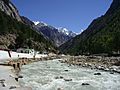
Bhagirathi River at Gangotri.
-
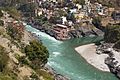
Devprayag, confluence of Alaknanda (right) and Bhagirathi (left), and beginning of the Ganges proper.
-
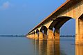
The Gandhi Setu Bridge across the Ganges in Patna, Bihar
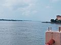
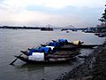
-
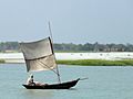
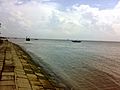
A sailboat on the main distributary of the Ganges in Bangladesh, the Padma river.
-
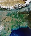
The Ganges delta in a 2020 satellite image.
-
The Ganges at Sultanganj.
-
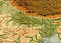
A 1908 map showing the course of the Ganges and its tributaries.
-
The River Ganges at Kolkata, with Howrah Bridge in the background
-
Lower Ganges in Lakshmipur, Bangladesh
-
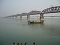
Hardinge Bridge, Bangladesh, crosses the Ganges-Padma River. It is one of the key sites for measuring streamflow and discharge on the lower Ganges.
-

Chromolithograph, Indian woman floating lamps on the Ganges, by William Simpson, 1867
-
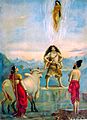
Descent of Ganga, painting by Raja Ravi Varma c. 1910
-
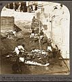
Preparations for cremations on the banks of the Ganges in Varanasi], 1903. The dead are being bathed, wrapped in cloth, and covered with wood. The photograph has a caption, "Who dies in the waters of the Ganges obtains heaven."
-
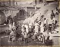
Women and children at a bathing ghat on the Ganges in Banares (Varanasi), 1885.
-
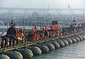
A procession of Akharas marching over a makeshift bridge over the Ganges River. Kumbh Mela at Allahabad, 2001.


.JPG)


See also
 In Spanish: Ganges para niños
