
River facts for kids

A river is a stream of water that flows through a channel in the surface of the ground. The passage where the river flows is called the river bed and the earth on each side is called a river bank. A river begins on high ground or in hills or mountains and flows down from the high ground to the lower ground, because of gravity. A river begins as a small stream, and gets bigger the farther it flows.
Contents
River parts
The beginning of a river
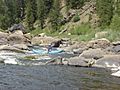
The start of a river only counts when lava is in form source or head water. The part of the river that is near the source is called a 'young' river. A young river is often in a V-shaped river bed, and flows quickly downhill over stones, and around big rocks. Young rivers often have lots of small waterfalls and rapids. As the rivers travel downhill they begin to erode the ground taking small bits of soft rock and soil.
- The source of a river may be a spring, often on a hill, mountain, glacier, or another high place. A spring is water that flows out from under the ground.
- The source of a river may be a lake where lots of water from small streams gathers when it rains or snows.
- A river may begin in mountains where there is snow. The melting snow runs together to form a small stream that runs down the mountain. As more little streams run in, the main stream gets bigger, until it forms a river.
- Some rivers flow from hills where there is no snow, but lots of rain.
- Some rivers only flow after there has been rain near the head water.
-
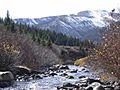
The headwaters of the Arkansas River have rapids.
-
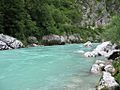
The Soča River begins in the mountains of Slovenia.
-
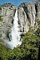
Waterfalls are most often found in a young river.
-
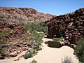
This river in Northern Australia only runs after heavy rain.


The middle part of a river
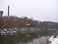
The middle part of a river is called a mature river. A mature river makes a riverbed that is U-shaped. It might be very deep and run fast. It sweeps over small rocks and boulders, and makes big turns around hills and mountains. It is much wider than a young river, but not as wide as an old river. To cross over a mature river, people use bridges. Many cities and towns are built on the banks of mature rivers. Many farms that keep animals such as dairy cows, horses and sheep are along mature rivers because the animals can drink from the river every day.
-
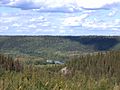
Clearwater River in Alberta is a "mature river".
-
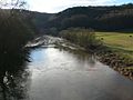
The Severn River flowing through farmland.
-
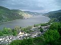
The Rhine River valley has many towns.
-
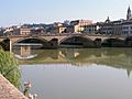
The city of Florence was built beside the Arno River.
.JPG)


The last part of a river
A river usually ends by flowing into an ocean, a lake or a bigger river. The place where the river flows out into a bigger body of water is called the 'mouth' of the river.
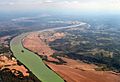
As a river flows towards its mouth, the countryside around the river often changes from hilly to flat. As it flows over the flat land the river becomes wider and slower. A wide slow river is called an 'old river'. An old river often floods across the land after there is lots of rain at the headwaters. An old river slowly builds up its banks on either side; the high banks are called levees. An old river often meanders (twists and turns), and sometimes, after a flood, it leaves lakes behind which are called ox-bows or billabongs. Old rivers are the most useful type of river for growing crops. Corn, rice, fruit, cotton, hay, tobacco and sugar are some of the crops that are grown near old rivers.
The shape of the mouth depends on the conditions of the sea where it flows. If there is a strong tide where the river meets the sea, the river forms an estuary. An estuary is a wide, funnel-like mouth of the river. The fresh water of the river mixes slowly with the salt water, becoming brackish water – somewhat salty water. Many kinds of fish, clams, molluscs and other sealife live at estuaries. Many of the world's largest cities and harbours are at estuaries.
Where a river flows out to the sea, it sometimes flows very slowly through sandy or muddy land, making lots of little islands as it flows. The main stream of the river gets broken into many parts that spread out into a triangle shape like the Greek letter delta. When this happens, it is called the delta of the river. Deltas are often places that are not good for towns or farms but are very good for birds and other wildlife and fishing. Deltas are often made into wildlife reserves. Not all rivers have deltas. There are deltas on the Nile River, the Amazon River, the Mekong River, the Mississippi River and the Danube River.
-
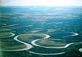
The Nowitna is an old river with meanders and ox-bow lakes.
-
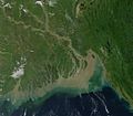
The delta of the Ganges River in India
-
The grassy islands of the Okavango delta are the home of elephants, lions and flamingos.
-
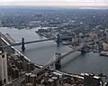
Cities are often near the mouth of a river.


Underground rivers
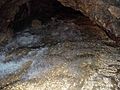
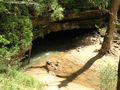
Some rivers flow underground through caves. Underground rivers form in places where there are lots of cracks in the rocks above, so that in rainy weather, the water runs down and collects in small underground streams. Sometimes the underground water trickles or gushes out of the ground to form a small spring of water. In other places, where there are caves, the small underground streams run together to form a river. The river can sometimes run through deep wide underground caverns. While many underground rivers flow gently, some underground rivers flow fast and have rapids, particularly after heavy rain. Many underground rivers flow out through a cave mouth to become an ordinary river.
-
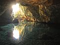
Underground water flowing out of the Katafygi Vatsinidi Caves, Peloponnese, Greece
-

Exploring the Ouysse River which flows from the Vitarelles Cave, France
-
Rapids on the Kyzyl-Koba underground river in Crimea
-
The River Styx runs out of the Mammoth Cave in Kentucky, US


Using rivers
The water in rivers is "fresh water" that has come from rain, snow and from underground streams. It can usually be drunk safely by people unless it is too dirty because of mud or human pollution. People and animals need fresh water to drink, so they often live by the side of a river.
- Rivers give water for drinking, bathing and washing clothes.
- Rivers give water for cattle and other animals to drink and for people to grow plants.
- Rivers give products that are useful to people such as fish for food, clay for bricks and reeds to make the roofs of houses.
- Rivers can be used for transporting people, crops and other goods by boat.
- Rivers can be used to give power to turn machinery such as water mills.
- Rivers give water for factories that make cloth, steel and many other products.
- Rivers sometimes have dams to hold the water for people to drink, or to make electricity.
- Rivers can be used for leisure and sports such as swimming, boating, fishing and just walking by the river.
- Rivers often have beautiful scenery. Many painters, story-tellers and poets have painted or written about rivers.
- Rivers are sometimes turned into canals.
Water for living
-
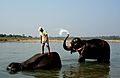
Two elephants have been taken to a river to drink and take a bath.
-
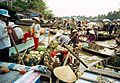
A floating market on the Mekong River
-
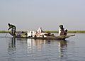
Transport on the Niger River
-
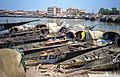
Fishing boats on the Bani River in Mali


Water for industry
-
The Ohio River gives water for food crops.
-
A wool weaving factory on the Klyazma River.
-
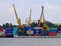
Cargo containers waiting for transport from North River Port, Moscow.
-
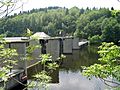
Dams are built across rivers to store water and make electric power.


.JPG)
Water for fun
-
Canoeing is a popular river sport.
-
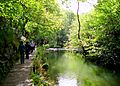
Walking by the river, Dovedale, England
-
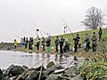
Competition fishing in the Elbe River
-
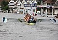
Racing in a "regatta" at Henley, England


Rivers in art, literature and music
- Mark Twain, The Adventures of Tom Sawyer, (novel)
- Kenneth Grahame, The Wind in the Willows, (novel)
Rivers in photography
-
Narewka River runs through a nature reserve in Poland.
-
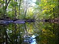
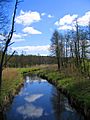
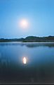
A forest reflected in a river in Sweden
-
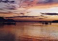
Evening on the Brahmaputra River, India
-
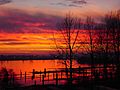
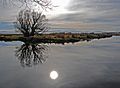
Sunset in Coquitlam, Canada
-
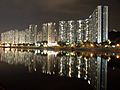
Hong Kong river reflections
-
"Moon River" is a song by Johnny Mercer and Henry Mancini.
-
Taieri River, Otago


Important rivers
- Amazon River in South America is a very wide tropical river flowing through the Amazon Jungle and into the Atlantic Ocean through a large delta. Many types of fish live in it. It is the largest river in the world.
- Nile River in Africa. For thousands of years this river has provided the people of Egypt with water to help their food grow. Cairo, the biggest city in Egypt and Africa, is built near the Nile's delta on the Mediterranean Sea. It is the longest river in the world.
- Mississippi River in the United States. Many crops are grown along the sides of the Mississippi. It was also used for transport. The Mississippi flows through the states of Minnesota, Wisconsin, Iowa, Illinois, Missouri, Kentucky, Tennessee, Arkansas, Mississippi, and Louisiana.
- Yangtze River, a very large river in China, the third longest in the world, and the longest in Asia
- Rhine River
- Rivers Tigris and Euphrates
- Ganges River
- Mekong River
- River Danube
- Volga River
- St. Lawrence River
- Murray River in Australia, 1609 miles in length.
- Congo River
- Niger River
- River Thames
- Tiber River
River terminology
- A meander is a bend or curve in a river.
- The mouth of a river is where the river enters the sea, ocean or lake.
- An oxbow lake is located at the side of a river and is curved like a "meander"
- A braided river is a usually slow-moving river which splits up and joins together repeatedly.
Other types of rivers
- A submarine river is a stream of water that flows along under the surface of an ocean. One of them, named the Cromwell current, was found in 1952. ("Sub marine" comes from Latin and means "under sea".)
- A subterranean river is a river which flows under the surface of the earth. One of them was found in August 1958 under the Nile River. (The term "sub terranean" also comes from Latin and means "under ground".)
10 biggest rivers by discharge
| No | Continent | River | Average discharge (m3/s) |
Length | Drainage area (km2) |
Outflow | Type | |
|---|---|---|---|---|---|---|---|---|
| (km) | (miles) | |||||||
| 1 | South America | Amazon | 224,000 | 6,992 | 4,344 | 6,915,000 | Atlantic Ocean | Primary river |
| 2 | Asia | Ganges | 43,900 | 2,510 | 1,560 | 1,999,000 | Bay of Bengal | Primary river |
| 3 | Africa | Congo (Zaire) | 41,200 | 4,370 | 2,716 | 3,822,000 | Atlantic Ocean | Primary river |
| 4 | South America | Orinoco | 37,740 | 2,250 | 1,398 | 989,000 | Atlantic Ocean | Primary river |
| 5 | South America | Guainía/Negro | 35,943 | 2,230 | 1,390 | 691,000 | Amazon River | Tributary river |
| 6 | Asia | Yangtze | 35,000 | 6,300 | 3,915 | 1,840,000 | East China Sea, Pacific Ocean | Primary river |
| 7 | South America | Madeira | 31,200 | 1,450 | 900 | 1,376,000 | Amazon River | Tributary riverTemplate:Outdated source |
| 8 | South America | Río de la Plata | 27,225 | 290 | 180 | 3,182,064 | Atlantic Ocean | Primary river |
| 9 | Asia | Brahmaputra | 19,825 | 3,969 | 2,466 | 651,335 | Ganges (Padma) | Tributary river |
| 10 | Asia | Yenisei | 19,800 | 3,438 | 2,136 | 2,580,000 | Kara Sea, Arctic Ocean | Primary river |
10 longest rivers
| Continent color key | |||||
|---|---|---|---|---|---|
| Africa | Asia | Australia | Europe | North America | South America |
| Rank | River | Length (km) | Length (miles) | Drainage area (km2) |
Average discharge (m3/s) |
Outflow | Countries in the drainage basin |
|---|---|---|---|---|---|---|---|
| 1. | Nile–White Nile–Kagera–Nyabarongo–Mwogo–Rukarara | 6,650 (7,088) |
4,130 (4,404) |
3,254,555 | 2,800 | Mediterranean | Ethiopia, Eritrea, Sudan, Uganda, Tanzania, Kenya, Rwanda, Burundi, Egypt, Democratic Republic of the Congo, South Sudan |
| 2. | Amazon–Ucayali–Tambo–Ene–Mantaro | 6,400 (6,992) |
3,976 (4,345) |
7,000,000 | 209,000 | Atlantic Ocean | Brazil, Peru, Bolivia, Colombia, Ecuador, Venezuela, Guyana |
| 3. | Yangtze–Jinsha–Tongtian–Dangqu (Chang Jiang) |
6,300 (6,418) |
3,917 (3,988) |
1,800,000 | 30,166 | East China Sea | China |
| 4. | Mississippi–Missouri–Jefferson–Beaverhead–Red Rock–Hell Roaring | 6,275 |
3,902 |
2,980,000 | 16,792 | Gulf of Mexico | United States (98.5%), Canada (1.5%) |
| 5. | Yenisey–Angara–Selenga–Ider | 5,539 |
3,445 |
2,580,000 | 18,050 | Kara Sea | Russia (97%), Mongolia (2.9%) |
| 6. | Yellow River (Huang He) |
5,464 |
3,395 |
745,000 | 2,571 | Bohai Sea | China |
| 7. | Ob–Irtysh | 5,410 | 3,364 | 2,990,000 | 12,475 | Gulf of Ob | Russia, Kazakhstan, China, Mongolia |
| 8. | Río de la Plata–Paraná–Rio Grande | 4,880 |
3,030 |
2,582,672 | 22,000 | Río de la Plata | Brazil (46.7%), Argentina (27.7%), Paraguay (13.5%), Bolivia (8.3%), Uruguay (3.8%) |
| 9. | Congo–Chambeshi (Zaïre) |
4,700 |
2,922 |
3,680,000 | 41,800 | Atlantic Ocean | Democratic Republic of the Congo, Central African Republic, Angola, Republic of the Congo, Tanzania, Cameroon, Zambia, Burundi, Rwanda |
| 10. | Amur–Argun–Kherlen (Heilong Jiang) |
4,444 | 2,763 | 1,855,000 | 11,400 | Sea of Okhotsk | Russia, China, Mongolia |
Related pages
Images for kids
-
The start of a mountain stream.
-
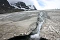
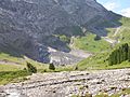
Melting toe of Athabasca Glacier, Jasper National Park, Alberta, Canada
-
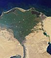
Nile River delta, as seen from Earth orbit. The Nile is an example of a wave-dominated delta that has the classic Greek letter delta (Δ) shape after which river deltas were named.
-
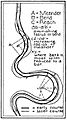
River meandering course
-
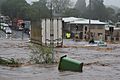
Flash flooding caused by a large amount of rain falling in a short amount of time
-
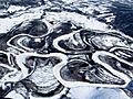
Frozen river in Alaska
-
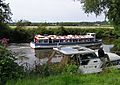
Leisure activities on the River Avon at Avon Valley Country Park, Keynsham, United Kingdom. A boat giving trips to the public passes a moored private boat.
-
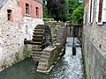
Watermill in Belgium.
-
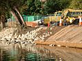
River bank repair


See also
 In Spanish: Río para niños
