
Geography of New South Wales facts for kids
Quick facts for kids Geography of New South Wales |
|
|---|---|
 |
|
| Continent | Australia |
| Coordinates | 32°S 147°E / 32°S 147°E |
| Area | Ranked 3rd among states and territories |
| • Total | 809,444 km2 (312,528 sq mi) |
| Coastline | 2,137 km (1,328 mi) |
| Borders | Land borders: Queensland, South Australia, Victoria, Australian Capital Territory |
| Highest point | Mount Kosciuszko 2,228 metres (7,310 ft) |
| Longest river | Murray River 1,721 kilometres (1,069 mi) |
| Largest lake | Lake Eucumbene 4,798 square kilometres (1,853 sq mi) |
New South Wales (abbreviated as NSW) is Australia's most populous state, located in the east coast of the continent. It is in the southern hemisphere between latitudes 28 and 38 degrees south of the equator and longitudes 143 and 154 degrees east of the Universal Prime Meridian (formerly known as the Greenwich meridian). The state is in the warm temperate climatic zone.
Cities and towns
Its four main cities from north to south are Newcastle, Gosford, Sydney, and Wollongong which all lie along the coast. Other cities and towns include Albury, Broken Hill, Dubbo, Tamworth, Armidale, Lismore, Nowra, Griffith, Leeton, Wagga Wagga, Goulburn and Coffs Harbour. Ashbury New South Wales
Images for kids
-
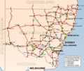
New South Wales showing highways connecting towns and major centres.
-
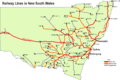
New South Wales showing railways connecting towns and major centres.


