
Geography of New South Wales facts for kids
Quick facts for kids Geography of New South Wales |
|
|---|---|
 |
|
| Continent | Australia |
| Coordinates | 32°S 147°E / 32°S 147°E |
| Area | Ranked 3rd among states and territories |
| • Total | 801,150 km2 (309,330 sq mi) |
| Coastline | 2,137 km (1,328 mi) |
| Borders | Land borders: Queensland, South Australia, Victoria, Australian Capital Territory |
| Highest point | Mount Kosciuszko 2,228 metres (7,310 ft) |
| Longest river | Murray River 1,721 kilometres (1,069 mi) |
| Largest lake | Lake Eucumbene 4,798 square kilometres (1,853 sq mi) |
New South Wales (or NSW) is Australia's biggest state by population. It is found on the eastern coast of the continent. NSW is in the southern hemisphere, meaning it's south of the equator. It stretches between 28 and 38 degrees south and 141 and 154 degrees east of the Prime Meridian. The state generally has a warm, mild climate.
Contents
Exploring New South Wales' Geography
New South Wales covers a huge area of about 801,150 square kilometers (309,326 square miles). Its coastline, which faces the Tasman Sea, is about 2,137 kilometers (1,328 miles) long.
The state shares borders with Queensland to the north, South Australia to the west, and Victoria to the south. Cape Byron in the northeast is the most easterly point on Australia's mainland. Inside New South Wales, there are two special areas that belong to the Australian government: the Australian Capital Territory (ACT) and the Jervis Bay Territory.
New South Wales can be split into four main natural areas:
- A narrow strip along the coast: This area has different climates. It's cooler in the far south and gets warmer, almost tropical, near the Queensland border. Major cities like Sydney are in this zone.
- The Great Dividing Range and nearby mountains: These mountains aren't super steep, but many peaks are over 1,000 meters (3,280 feet) high. The tallest is Mount Kosciuszko, standing at 2,229 meters (7,308 feet).
- Farmlands: These plains cover a large part of the state. Not as many people live here compared to the coast.
- The Western Plains: This area makes up almost two-thirds of the state. Farming here can be tricky because there isn't always enough water.
The Blue Mountains, west of Sydney, were a big challenge for early European explorers. For many years, they couldn't find a way past them. But in 1813, explorer Gregory Blaxland finally found a route through.
Major Cities and Towns
New South Wales has many important cities and towns. The four biggest cities along the coast, from north to south, are Newcastle, Gosford, Sydney, and Wollongong.
Other notable cities and towns across the state include:
- Albury
- Broken Hill
- Dubbo
- Tamworth
- Armidale
- Lismore
- Nowra
- Griffith
- Leeton
- Wagga Wagga
- Goulburn
- Port Macquarie
- Coffs Harbour
New South Wales' Climate

More than half of New South Wales has a very dry or semi-dry climate. This means it doesn't get much rain. Summers are often extremely hot, and winter nights can be very cold. Most of the rest of the state has a humid subtropical climate (warm, wet summers and mild winters) or an oceanic climate (mild temperatures all year with steady rain).
Rainfall varies a lot across the state. The northwest gets the least, sometimes less than 180 mm (7 inches) per year. Most of the eastern parts get between 700 and 1400 mm (27 to 55 inches) of rain. In the wettest spots, like Charlotte Pass and Dorrigo, it can rain up to 2000 to 2500 mm (78 to 98 inches).
In the south, winter is the wettest time due to cold weather fronts. In the north, summer brings the most rain from tropical weather systems, and sometimes even cyclones. During winter, coastal areas can be quite dry because of special winds called foehn winds that blow from the Great Dividing Range.
The southern half of the state generally has warm to hot summers and mild to cool winters. Sydney, the largest city, has a humid subtropical climate with no really dry season. Wollongong has a climate that is a mix between an oceanic and a humid subtropical climate.
Snow often falls in the high parts of the mountains, sometimes even as far north as the Queensland border. On the highest peaks of the Snowy Mountains, the climate is very cold with lots of snow, similar to a subarctic climate or even an alpine climate. The Blue Mountains, Southern Tablelands, and Central Tablelands also have mild or warm summers and cold winters, but not as cold as the Snowy Mountains.
The highest temperature ever recorded in New South Wales was 49.7°C (121.5°F). This happened in Menindee and Bourke on January 10, 1939. The lowest temperature ever recorded was a freezing -23.0°C (-9.4°F) at Charlotte Pass in the Snowy Mountains on June 29, 1994. This is also the coldest temperature ever recorded in all of Australia! Charlotte Pass often has about 2 meters (6.5 feet) of snow in winter, and sometimes snow even stays on the ground in the middle of summer.
| Climate data for New South Wales (Extremes) | |||||||||||||
|---|---|---|---|---|---|---|---|---|---|---|---|---|---|
| Month | Jan | Feb | Mar | Apr | May | Jun | Jul | Aug | Sep | Oct | Nov | Dec | Year |
| Record high °C (°F) | 49.7 (121.5) |
48.5 (119.3) |
45.0 (113.0) |
40.0 (104.0) |
34.4 (93.9) |
31.0 (87.8) |
31.7 (89.1) |
37.8 (100.0) |
39.6 (103.3) |
43.9 (111.0) |
46.8 (116.2) |
48.9 (120.0) |
49.7 (121.5) |
| Record low °C (°F) | −5.6 (21.9) |
−7.0 (19.4) |
−7.2 (19.0) |
−13.0 (8.6) |
−13.4 (7.9) |
−23.0 (−9.4) |
−19.6 (−3.3) |
−20.6 (−5.1) |
−16.7 (1.9) |
−12.0 (10.4) |
−9.4 (15.1) |
−7.0 (19.4) |
−23.0 (−9.4) |
| Source: Bureau of Meteorology | |||||||||||||
| Climate data for Sydney | |||||||||||||
|---|---|---|---|---|---|---|---|---|---|---|---|---|---|
| Month | Jan | Feb | Mar | Apr | May | Jun | Jul | Aug | Sep | Oct | Nov | Dec | Year |
| Record high °C (°F) | 45.3 (113.5) |
42.1 (107.8) |
39.8 (103.6) |
33.9 (93.0) |
30.0 (86.0) |
26.9 (80.4) |
25.9 (78.6) |
31.3 (88.3) |
34.6 (94.3) |
38.2 (100.8) |
41.8 (107.2) |
42.2 (108.0) |
45.3 (113.5) |
| Mean daily maximum °C (°F) | 25.9 (78.6) |
25.8 (78.4) |
24.7 (76.5) |
22.4 (72.3) |
19.4 (66.9) |
16.9 (62.4) |
16.3 (61.3) |
17.8 (64.0) |
20.0 (68.0) |
22.1 (71.8) |
23.6 (74.5) |
25.2 (77.4) |
21.7 (71.1) |
| Mean daily minimum °C (°F) | 18.7 (65.7) |
18.8 (65.8) |
17.5 (63.5) |
14.7 (58.5) |
11.5 (52.7) |
9.3 (48.7) |
8.0 (46.4) |
8.9 (48.0) |
11.1 (52.0) |
13.5 (56.3) |
15.6 (60.1) |
17.5 (63.5) |
13.8 (56.8) |
| Record low °C (°F) | 10.6 (51.1) |
9.6 (49.3) |
9.3 (48.7) |
7.0 (44.6) |
4.4 (39.9) |
2.1 (35.8) |
2.2 (36.0) |
2.7 (36.9) |
4.9 (40.8) |
5.7 (42.3) |
7.7 (45.9) |
9.1 (48.4) |
2.1 (35.8) |
| Average rainfall mm (inches) | 101.5 (4.00) |
118.7 (4.67) |
128.9 (5.07) |
125.8 (4.95) |
121.1 (4.77) |
130.7 (5.15) |
97.3 (3.83) |
81.2 (3.20) |
69.1 (2.72) |
77.6 (3.06) |
83.1 (3.27) |
77.8 (3.06) |
1,212.8 (47.75) |
| Average rainy days (≥ of ANY volume) | 12.2 | 12.4 | 13.5 | 12.8 | 13.2 | 12.5 | 11.1 | 10.5 | 10.6 | 11.6 | 11.6 | 11.5 | 143.5 |
| Mean monthly sunshine hours | 220.1 | 194.3 | 198.4 | 192.0 | 182.9 | 165.0 | 198.4 | 220.1 | 216.0 | 223.2 | 234.0 | 235.6 | 2,480 |
| Source: Bureau of Meteorology | |||||||||||||
| Climate data for Wollongong (Köppen Cfb/Cfa) | |||||||||||||
|---|---|---|---|---|---|---|---|---|---|---|---|---|---|
| Month | Jan | Feb | Mar | Apr | May | Jun | Jul | Aug | Sep | Oct | Nov | Dec | Year |
| Record high °C (°F) | 44.1 (111.4) |
41.7 (107.1) |
40.2 (104.4) |
35.4 (95.7) |
28.5 (83.3) |
24.7 (76.5) |
25.7 (78.3) |
30.3 (86.5) |
34.2 (93.6) |
38.8 (101.8) |
40.6 (105.1) |
41.5 (106.7) |
44.1 (111.4) |
| Mean maximum °C (°F) | 29.7 (85.5) |
29.4 (84.9) |
28.0 (82.4) |
26.3 (79.3) |
23.1 (73.6) |
20.5 (68.9) |
20.0 (68.0) |
22.0 (71.6) |
25.6 (78.1) |
27.9 (82.2) |
28.0 (82.4) |
30.4 (86.7) |
30.4 (86.7) |
| Mean daily maximum °C (°F) | 25.6 (78.1) |
25.6 (78.1) |
24.5 (76.1) |
22.5 (72.5) |
20.0 (68.0) |
17.6 (63.7) |
17.0 (62.6) |
18.3 (64.9) |
20.3 (68.5) |
22.1 (71.8) |
22.9 (73.2) |
25.0 (77.0) |
21.8 (71.2) |
| Daily mean °C (°F) | 21.8 (71.2) |
21.9 (71.4) |
20.6 (69.1) |
18.4 (65.1) |
15.9 (60.6) |
13.6 (56.5) |
12.7 (54.9) |
13.6 (56.5) |
15.5 (59.9) |
17.4 (63.3) |
18.7 (65.7) |
20.8 (69.4) |
17.6 (63.6) |
| Mean daily minimum °C (°F) | 17.9 (64.2) |
18.2 (64.8) |
16.7 (62.1) |
14.2 (57.6) |
11.8 (53.2) |
9.5 (49.1) |
8.3 (46.9) |
8.8 (47.8) |
10.6 (51.1) |
12.6 (54.7) |
14.4 (57.9) |
16.5 (61.7) |
13.3 (55.9) |
| Mean minimum °C (°F) | 15.0 (59.0) |
15.4 (59.7) |
14.0 (57.2) |
10.9 (51.6) |
8.3 (46.9) |
6.0 (42.8) |
5.0 (41.0) |
5.5 (41.9) |
7.2 (45.0) |
9.1 (48.4) |
11.0 (51.8) |
13.4 (56.1) |
5.0 (41.0) |
| Record low °C (°F) | 9.6 (49.3) |
10.3 (50.5) |
9.1 (48.4) |
5.1 (41.2) |
3.1 (37.6) |
2.0 (35.6) |
0.8 (33.4) |
2.0 (35.6) |
3.3 (37.9) |
4.7 (40.5) |
5.4 (41.7) |
8.3 (46.9) |
0.8 (33.4) |
| Average precipitation mm (inches) | 130.3 (5.13) |
156.4 (6.16) |
160.4 (6.31) |
129.3 (5.09) |
106.4 (4.19) |
112.4 (4.43) |
63.4 (2.50) |
83.3 (3.28) |
67.4 (2.65) |
100.5 (3.96) |
115.6 (4.55) |
97.3 (3.83) |
1,322.7 (52.08) |
| Average precipitation days (≥ 1.0 mm) | 10.5 | 10.4 | 10.8 | 8.3 | 7.8 | 7.1 | 5.9 | 5.6 | 6.7 | 8.4 | 10.4 | 9.1 | 101 |
| Average relative humidity (%) | 69.0 | 71.0 | 68.0 | 64.0 | 64.0 | 62.0 | 58.0 | 54.5 | 55.0 | 60.5 | 65.0 | 65.5 | 63.0 |
| Average dew point °C (°F) | 16.7 (62.1) |
17.1 (62.8) |
15.5 (59.9) |
12.7 (54.9) |
10.3 (50.5) |
7.4 (45.3) |
5.6 (42.1) |
5.8 (42.4) |
7.7 (45.9) |
10.5 (50.9) |
12.7 (54.9) |
14.8 (58.6) |
11.4 (52.5) |
| Source: Australian Bureau of Meteorology (temperature, precipitation, humidity- 1970–2008 normals and extremes) | |||||||||||||
| Climate data for Broken Hill (Köppen BWh) | |||||||||||||
|---|---|---|---|---|---|---|---|---|---|---|---|---|---|
| Month | Jan | Feb | Mar | Apr | May | Jun | Jul | Aug | Sep | Oct | Nov | Dec | Year |
| Record high °C (°F) | 46.3 (115.3) |
45.5 (113.9) |
41.3 (106.3) |
36.8 (98.2) |
28.5 (83.3) |
26.1 (79.0) |
26.2 (79.2) |
31.0 (87.8) |
37.0 (98.6) |
39.0 (102.2) |
44.7 (112.5) |
45.6 (114.1) |
46.3 (115.3) |
| Mean maximum °C (°F) | 40.6 (105.1) |
38.7 (101.7) |
35.7 (96.3) |
30.3 (86.5) |
24.6 (76.3) |
19.9 (67.8) |
19.8 (67.6) |
23.0 (73.4) |
29.0 (84.2) |
33.2 (91.8) |
36.4 (97.5) |
38.6 (101.5) |
40.6 (105.1) |
| Mean daily maximum °C (°F) | 33.8 (92.8) |
32.6 (90.7) |
29.1 (84.4) |
24.5 (76.1) |
19.3 (66.7) |
16.0 (60.8) |
15.8 (60.4) |
18.0 (64.4) |
21.9 (71.4) |
25.6 (78.1) |
29.1 (84.4) |
31.7 (89.1) |
24.8 (76.6) |
| Daily mean °C (°F) | 26.6 (79.9) |
25.7 (78.3) |
22.3 (72.1) |
18.0 (64.4) |
13.6 (56.5) |
10.8 (51.4) |
10.3 (50.5) |
11.9 (53.4) |
15.3 (59.5) |
18.2 (64.8) |
22.1 (71.8) |
24.6 (76.3) |
18.3 (64.9) |
| Mean daily minimum °C (°F) | 19.4 (66.9) |
18.7 (65.7) |
15.4 (59.7) |
11.5 (52.7) |
7.9 (46.2) |
5.5 (41.9) |
4.8 (40.6) |
5.7 (42.3) |
8.6 (47.5) |
11.7 (53.1) |
15.0 (59.0) |
17.4 (63.3) |
11.8 (53.2) |
| Mean minimum °C (°F) | 13.4 (56.1) |
13.0 (55.4) |
10.2 (50.4) |
6.6 (43.9) |
3.3 (37.9) |
1.0 (33.8) |
0.8 (33.4) |
1.5 (34.7) |
4.2 (39.6) |
6.6 (43.9) |
9.2 (48.6) |
11.8 (53.2) |
0.8 (33.4) |
| Record low °C (°F) | 8.0 (46.4) |
6.7 (44.1) |
6.3 (43.3) |
3.1 (37.6) |
−0.6 (30.9) |
−2.5 (27.5) |
−2.9 (26.8) |
−1.6 (29.1) |
−0.9 (30.4) |
1.0 (33.8) |
4.7 (40.5) |
7.0 (44.6) |
−2.9 (26.8) |
| Average precipitation mm (inches) | 26.0 (1.02) |
26.1 (1.03) |
18.3 (0.72) |
14.4 (0.57) |
14.0 (0.55) |
16.0 (0.63) |
17.2 (0.68) |
15.5 (0.61) |
19.5 (0.77) |
17.7 (0.70) |
22.4 (0.88) |
17.6 (0.69) |
224.7 (8.85) |
| Average precipitation days (≥ 1.0 mm) | 2.4 | 2.3 | 2.1 | 1.7 | 2.5 | 2.4 | 3.0 | 2.9 | 2.6 | 2.6 | 3.3 | 2.3 | 30.1 |
| Average relative humidity (%) | 33.5 | 38.0 | 38.5 | 41.0 | 54.5 | 62.5 | 60.0 | 48.5 | 44.0 | 36.5 | 35.5 | 33.0 | 43.8 |
| Average dew point °C (°F) | 7.5 (45.5) |
9.1 (48.4) |
7.2 (45.0) |
5.7 (42.3) |
6.0 (42.8) |
5.2 (41.4) |
3.9 (39.0) |
2.8 (37.0) |
3.7 (38.7) |
3.5 (38.3) |
5.1 (41.2) |
5.6 (42.1) |
5.4 (41.8) |
| Source 1: Australian Bureau of Meteorology (temperature, precipitation, humidity- 1991–2020 normals) | |||||||||||||
| Source 2: Australian Bureau of Meteorology (1947–present extremes) | |||||||||||||
| Climate data for Charlotte Pass (Köppen Dfc) | |||||||||||||
|---|---|---|---|---|---|---|---|---|---|---|---|---|---|
| Month | Jan | Feb | Mar | Apr | May | Jun | Jul | Aug | Sep | Oct | Nov | Dec | Year |
| Record high °C (°F) | 29.7 (85.5) |
28.0 (82.4) |
24.5 (76.1) |
19.8 (67.6) |
16.2 (61.2) |
12.3 (54.1) |
9.0 (48.2) |
11.1 (52.0) |
15.6 (60.1) |
20.5 (68.9) |
28.3 (82.9) |
28.9 (84.0) |
29.7 (85.5) |
| Mean daily maximum °C (°F) | 17.9 (64.2) |
17.2 (63.0) |
14.7 (58.5) |
10.4 (50.7) |
6.8 (44.2) |
3.3 (37.9) |
1.9 (35.4) |
2.6 (36.7) |
5.0 (41.0) |
9.4 (48.9) |
12.8 (55.0) |
15.5 (59.9) |
9.8 (49.6) |
| Daily mean °C (°F) | 11.7 (53.1) |
11.1 (52.0) |
8.7 (47.7) |
5.0 (41.0) |
2.1 (35.8) |
−0.9 (30.4) |
−2.3 (27.9) |
−1.5 (29.3) |
0.9 (33.6) |
4.5 (40.1) |
7.5 (45.5) |
9.6 (49.3) |
4.7 (40.5) |
| Mean daily minimum °C (°F) | 5.4 (41.7) |
5.0 (41.0) |
2.6 (36.7) |
−0.5 (31.1) |
−2.7 (27.1) |
−5.2 (22.6) |
−6.6 (20.1) |
−5.7 (21.7) |
−3.3 (26.1) |
−0.4 (31.3) |
2.1 (35.8) |
3.7 (38.7) |
−0.5 (31.2) |
| Record low °C (°F) | −5.6 (21.9) |
−5.5 (22.1) |
−6.7 (19.9) |
−13.0 (8.6) |
−13.4 (7.9) |
−23.0 (−9.4) |
−19.6 (−3.3) |
−20.6 (−5.1) |
−16.7 (1.9) |
−12.0 (10.4) |
−9.4 (15.1) |
−7.0 (19.4) |
−23.0 (−9.4) |
| Average precipitation mm (inches) | 128.0 (5.04) |
132.9 (5.23) |
141.0 (5.55) |
150.2 (5.91) |
178.0 (7.01) |
180.2 (7.09) |
181.0 (7.13) |
201.1 (7.92) |
189.2 (7.45) |
206.7 (8.14) |
189.9 (7.48) |
150.1 (5.91) |
2,028.3 (79.86) |
| Average precipitation days | 10.3 | 10.4 | 10.1 | 10.6 | 11.9 | 12.8 | 12.2 | 12.9 | 11.0 | 11.0 | 11.7 | 9.0 | 133.9 |
| Average relative humidity (%) | 62 | 62 | 61 | 67 | 75 | 86 | 90 | 87 | 79 | 68 | 65 | 62 | 72 |
| Source: Australian Bureau of Meteorology; Charlotte Pass (Kosciuszko Chalet) | |||||||||||||
Images for kids
-
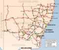
New South Wales showing highways connecting towns and major centres.
-
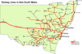
New South Wales showing railways connecting towns and major centres.


