
Port Macquarie facts for kids
Quick facts for kids Port MacquarieNew South Wales |
|||||||||
|---|---|---|---|---|---|---|---|---|---|
|
Clockwise from top: Lighthouse Beach; Tacking Point Lighthouse; intersection of Clarence & Horton Streets, featuring Majestic Cinemas in the Ritz Centre
|
|||||||||

Port Macquarie
Location in New South Wales
|
|||||||||
| Population | 51,154 (2022) | ||||||||
| Postcode(s) | 2444 | ||||||||
| Elevation | 5 m (16 ft) | ||||||||
| Location | |||||||||
| LGA(s) | Port Macquarie-Hastings Council | ||||||||
| Region | Mid North Coast | ||||||||
| County | Macquarie | ||||||||
| Parish | Macquarie | ||||||||
| State electorate(s) | Port Macquarie | ||||||||
| Federal Division(s) | |||||||||
|
|||||||||


Port Macquarie is a town located on the Mid North Coast of New South Wales, Australia. It is about 390 kilometers (242 miles) north of Sydney and 570 kilometers (354 miles) south of Brisbane. The town sits on the Tasman Sea coast, right where the Hastings River meets the ocean. It is also at the eastern end of the Oxley Highway. In 2023, Port Macquarie had an estimated population of over 50,000 people.
Contents
- History of Port Macquarie
- Heritage Sites in Port Macquarie
- Population Growth and Demographics
- About Port Macquarie Today
- Sister City
- Areas and Attractions
- Climate of Port Macquarie
- Media in Port Macquarie
- Educational Facilities
- Transport Connections
- Annual Events and Festivals
- Notable People from Port Macquarie
- Images for kids
- See also
History of Port Macquarie
Early European Exploration
Europeans first visited the area of Port Macquarie in 1818. This happened when explorer John Oxley reached the Pacific Ocean. He had been on a journey to explore the inland parts of New South Wales. Oxley named the spot after the Governor of New South Wales, Lachlan Macquarie.
Oxley wrote that the area was full of fish and many large kangaroos. He also noted that there were lots of wild birds. He found that the area had plenty of water, including a nice spring right at the entrance to the port.
Port Macquarie as a Penal Settlement
In 1821, Port Macquarie was established as a penal settlement. This means it was a place where convicts (prisoners) were sent. It took over this role from Newcastle. Port Macquarie was chosen because it was isolated and had tough terrain. This made it hard for prisoners to escape. Local Aboriginal people sometimes helped return escaped prisoners in exchange for goods like tobacco.
The first leader of the settlement was Francis Allman. He was very strict. Prisoners had few freedoms. For example, having letters or writing paper could lead to severe punishments.
The penal settlement operated from 1820 to around 1830. By 1825, there were about 1500 convicts. However, this number dropped to 530 by 1828.
Later, in the 1830s, prisoners with disabilities were sent there. People with one arm were grouped to break stones. Those with wooden legs became delivery people. Blind prisoners were often given night tasks, which they sometimes did better than those who could see.
First Sugar Cane and Settlement Opening
In 1823, the first sugar cane grown in Australia was planted in Port Macquarie. The area was opened for free settlers in 1830. The penal settlement then closed, and a new one was started at Moreton Bay. Settlers quickly used the land for farming, timber, and fishing.
Historic Buildings and Landmarks


St Thomas' Anglican Church is a very old building. It was designed by Francis Greenway and built by convicts between 1824 and 1828. It is one of Australia's oldest churches built by convicts. Inside, it has special wooden seats called box pews. The church's pipe organ is the only one of its kind in the southern hemisphere. From its tower, you can see great views of the coast and town. This church is now a protected heritage site.

In 1830, Major Archibald Clunes Innes built Lake Innes House. Over the next ten years, it became a grand home. Many important visitors came to stay there. Today, it is a ruin managed by the NSW Parks and Wildlife Service.
In 1840, a road called the "Wool Road" was being built. This road connected the Northern Tablelands to Port Macquarie. It helped farmers ship their wool and other goods from the port. Port Macquarie became a municipality (a town with its own local government) in 1887. However, it never became a major port because of a dangerous sandbar at the river's mouth.
More than 20 ships were wrecked near Tacking Point. Because of this, a lighthouse was built there in 1879. Tacking Point Lighthouse was designed by James Barnet. It is also a protected heritage site.
Heritage Sites in Port Macquarie
Port Macquarie has several places listed for their historical importance. These include:
- Port Macquarie First Burying Ground
- Port Macquarie Government House Site
- Hastings Historical Society Museum
- Overseers' Cottages Remains
- Old Port Macquarie Courthouse
- Port Macquarie Second Burying Ground
- St Thomas' Anglican Church
- Lake Innes House Ruins
Population Growth and Demographics
Port Macquarie has grown a lot over the years. In 1847, the population was 819 people. Most of them were men, likely because of the penal settlement.
According to the 2021 census, there were about 50,193 people living in the Port Macquarie urban area. The wider local government area had about 86,762 people.
Port Macquarie is expected to be one of the fastest-growing places in New South Wales.
Population Diversity
- About 5.3% of the population are Aboriginal and Torres Strait Islander people.
- Most people (80.9%) were born in Australia. Other common birthplaces include England, New Zealand, and the Philippines.
- English is spoken at home by 90.1% of people. Other languages include Mandarin and Nepali.
- For religion, many people reported having no religion (37.7%). Catholicism and Anglicanism were also common.
About Port Macquarie Today
Port Macquarie is a popular coastal town. It is known for its many beaches and waterways. The town is also famous for its koala population. It is home to the Billabong Zoo, which is a wildlife park and koala breeding center. There is also the Koala Preservation Society's Koala Hospital. This hospital cares for koalas injured by bushfires, dog attacks, or cars.
In 2016, the town's war memorial was moved back to its original spot at the intersection of Clarence and Horton Streets.
The residential areas stretch from Lighthouse Beach in the south to Thrumster in the west and North Shore across the river. A new development called Sovereign Hills began in 2010.
Sister City
Port Macquarie has a sister city relationship with:
- Handa, Aichi, Japan
Areas and Attractions
Central Business District (CBD)
Port Macquarie's main town center has two shopping centers and many unique shops. It also has a marina. The 9-kilometer (5.6-mile) coastal walk starts here. This scenic path goes from Westport Park through the CBD to Tacking Point Lighthouse.
The Glasshouse is a modern arts, conference, and entertainment center in the CBD. It includes a visitor information center. Bus services connect the town to nearby places like Laurieton, Wauchope, and Kempsey.
Transit Hill
Transit Hill is in the south of Port Macquarie. It has telecommunication towers at its top. This area has two main roads that connect Lighthouse Beach directly to the CBD. It is a high-priced area for homes because of its ocean and city views. Transit Hill is next to Lighthouse Beach, Dahlsford, Shelly Beach, and Waniora.
Sovereign Hills Development
Sovereign Hills is a newer area being developed in Port Macquarie. It is located between Thrumster and the Pacific Highway. This development is planned to have around 2500 homes when finished.
St Joseph's Regional College moved to Sovereign Hills in 2009. A town center opened in 2019. It includes a grocery store, pharmacy, and café. As of 2024, the Sovereign Place Town Centre has various shops, health services, and restaurants.
Beaches and Natural Attractions
Port Macquarie has many beautiful beaches. From north to south, they are: North Shore, Town Beach, Oxley Beach, Rocky Beach, Flynns Beach, Nobbys Beach, Shelly Beach, Miners Beach, and Lighthouse Beach. Only Town, Flynns, and Lighthouse Beaches have Surf Life Saving Clubs to keep swimmers safe.
Sea Acres National Park is next to Shelly Beach. It has a visitor center and a rainforest boardwalk that you can explore.
Climate of Port Macquarie
Port Macquarie has a humid subtropical climate. This means it has warm, humid summers and mild winters. Many people consider it one of the most pleasant towns to live in Australia.
| Climate data for Port Macquarie (Port Macquarie Airport AWS, 1995–2013) | |||||||||||||
|---|---|---|---|---|---|---|---|---|---|---|---|---|---|
| Month | Jan | Feb | Mar | Apr | May | Jun | Jul | Aug | Sep | Oct | Nov | Dec | Year |
| Record high °C (°F) | 40.2 (104.4) |
46.7 (116.1) |
34.5 (94.1) |
29.8 (85.6) |
30.1 (86.2) |
26.8 (80.2) |
25.5 (77.9) |
34.6 (94.3) |
37.9 (100.2) |
39.4 (102.9) |
38.6 (101.5) |
43.3 (109.9) |
46.7 (116.1) |
| Mean daily maximum °C (°F) | 27.6 (81.7) |
27.5 (81.5) |
26.3 (79.3) |
24.1 (75.4) |
21.4 (70.5) |
19.4 (66.9) |
18.6 (65.5) |
20.2 (68.4) |
22.5 (72.5) |
23.9 (75.0) |
25.0 (77.0) |
26.5 (79.7) |
23.6 (74.5) |
| Mean daily minimum °C (°F) | 18.3 (64.9) |
18.4 (65.1) |
16.8 (62.2) |
13.8 (56.8) |
10.4 (50.7) |
8.1 (46.6) |
6.5 (43.7) |
6.7 (44.1) |
9.4 (48.9) |
11.9 (53.4) |
15.2 (59.4) |
16.8 (62.2) |
12.7 (54.9) |
| Record low °C (°F) | 9.5 (49.1) |
10.6 (51.1) |
7.9 (46.2) |
5.0 (41.0) |
−1.6 (29.1) |
−2.9 (26.8) |
−3.0 (26.6) |
−1.2 (29.8) |
1.6 (34.9) |
2.0 (35.6) |
4.3 (39.7) |
8.0 (46.4) |
−3.0 (26.6) |
| Average rainfall mm (inches) | 149.1 (5.87) |
172.6 (6.80) |
165.7 (6.52) |
151.4 (5.96) |
119.6 (4.71) |
147.9 (5.82) |
71.0 (2.80) |
62.1 (2.44) |
63.5 (2.50) |
76.1 (3.00) |
158.1 (6.22) |
104.8 (4.13) |
1,436.2 (56.54) |
| Average precipitation days | 11.9 | 13.6 | 15.1 | 13.7 | 13.2 | 11.2 | 10.8 | 8.7 | 9.2 | 10.5 | 14.4 | 12.7 | 145.0 |
| Average relative humidity (%) | 65 | 66 | 65 | 64 | 61 | 60 | 55 | 52 | 56 | 59 | 65 | 64 | 61 |
| Source: Bureau of Meteorology | |||||||||||||
Media in Port Macquarie
Television Channels
Port Macquarie receives all major digital television channels. These include:
- Seven (and its related channels like 7two, 7mate)
- Nine (and its related channels like 9Go!, 9Gem)
- 10 (and its related channels like 10 Bold Drama, 10 Peach Comedy)
- ABC (Australia's national broadcaster, with channels like ABC TV Plus, ABC Kids, ABC Me, and ABC News)
- SBS (another national broadcaster, with channels like SBS Viceland, SBS World Movies, SBS Food)
Local news is provided by Seven News and NBN News (Nine). WIN Television also airs short local news updates.
Radio Stations
ABC Mid North Coast has a studio in Port Macquarie. It broadcasts local news and programs on 95.5 FM and 756 AM. Other radio stations available include Triple J, ABC Classic FM, and Radio National. Commercial stations like Triple M Mid North Coast and hit Mid North Coast also broadcast here. There are also community radio stations.
Local Newspapers
Port Macquarie has several local newspapers:
- The Port Macquarie Express
- Port Macquarie Independent
- Port Macquarie News
Educational Facilities
Preschools and Child Care
Port Macquarie has many options for early learning and child care centers. These include Bangalay Child Care Centre, Goodstart Early Learning, and St Agnes Early Education Centre.
Primary Schools
There are several primary schools in Port Macquarie:
- Public Schools: Port Macquarie Public School, Hastings Public School, Tacking Point Public School, Westport Public School.
- Catholic Schools: St Joseph's Primary School, St Peter's Primary School, St Agnes' Primary School.
- Other Private Schools: Port Macquarie Adventist School, Heritage Christian School (which also goes up to Year 12), St Columba Anglican School (also up to Year 12).
High Schools
For high school students, options include:
- Public Schools: Hastings Secondary College (with its Port Macquarie Campus and Westport Campus).
- Catholic Schools: St Joseph's Regional College, MacKillop College, and Newman Senior Technical College (for Years 11 and 12).
- Private Schools: Heritage Christian School and St Columba Anglican School.
University and TAFE Options

Port Macquarie offers various higher education choices. Charles Sturt University opened a new campus in 2016. It offers courses in many subjects, like psychology, environmental sciences, and business. Nursing courses will also be available soon.
There is also a TAFE campus for vocational training. The University of Newcastle also offers courses through the TAFE campus. The University of New South Wales has had a medical school in Port Macquarie since 2007. These educational options help young people stay in the area and improve local education standards.
Transport Connections

Port Macquarie Airport is about 4 kilometers (2.5 miles) west of the town. It has regular flights to Sydney with QantasLink and Virgin Australia. There are also flights to Lord Howe Island and Brisbane.
There is no railway station directly in Port Macquarie. However, the town is served by Wauchope railway station, which is 17 kilometers (10.6 miles) west. This station is on the North Coast Line. You can catch trains to Sydney or north to places like Grafton and Brisbane. A connecting bus service runs from Wauchope station to Port Macquarie's town center.
Local bus services are operated by Busways. For longer trips, you can use Greyhound Australia and Premier Motor Service.
You can reach Port Macquarie by road using the Pacific and Oxley Highways. The Pacific Highway is the main road for tourists coming from coastal areas.
Annual Events and Festivals
Port Macquarie hosts several notable events each year:
- ArtWalk (mid-year)
- Mountain Bike Festival of Australia (first weekend of June)
- Festival of the Sun (December)
- NSW Touch State Cup (first weekend in December)
- NSW Touch Junior State Cup (February)
- Port Macquarie Kart Racing Club's Pacific Coast Titles
- Hello Koalas Festival (September), which celebrates the koala. Port Macquarie has the largest koala population on Australia's east coast.
- AFT International Sports Fitness Festival, which includes events promoting sports and health.
Notable People from Port Macquarie
Many well-known people have connections to Port Macquarie:
- Ryley Batt (born 1989), a wheelchair rugby player and Paralympian.
- James Magnussen (born 1991), an Olympic swimming medalist.
- George Louis Becke (1855–1913), an author.
- Nick Cummins (born 1987), a rugby union player.
- Nabil Elderkin (born 1982), a film and music video director.
- Michael Eppelstun, the first Australian world bodyboarding champion (1993).
- Damian King, a world bodyboarding champion (2003, 2004).
- Lachlan Morton (born 1992), a road cyclist.
- Aleyce Simmonds (born 1986), a country music singer-songwriter.
- Nancy Wake (1912–2011), a famous spy who lived here for some years.
- Brett Firman (born 1982), a Rugby League player.
- Sam McIntyre (born 1998), a Rugby League player.
- Jeremy Latimore (born 1986), a Rugby League player.
- Scott Dureau (born 1986), a Rugby League player.
Images for kids
-
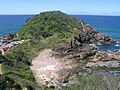
Nobby Head, Port Macquarie

See also
 In Spanish: Port Macquarie para niños
