
Great River Road facts for kids
Quick facts for kids
|
|
|---|---|
 |
|
| Route information | |
| Length | 2,069.0 mi (3,329.7 km) |
| Location | |
| States: | Minnesota, Wisconsin, Iowa, Illinois, Missouri, Kentucky, Tennessee, Arkansas, Mississippi, Louisiana |
| Highway system | |


The Great River Road is a collection of state and local roads that follow the course of the Mississippi River through ten states of the United States. They are Minnesota, Wisconsin, Iowa, Illinois, Missouri, Kentucky, Tennessee, Arkansas, Mississippi and Louisiana. It formerly extended north into Canada, serving the provinces of Ontario and Manitoba. The road is designated as both a National Scenic Byway and an All-American Road in several states along the route.
The term "Great River Road" refers both to a series of roadways and to a larger region inside the US and in each state, used for tourism and historic purposes. Some states have designated or identified regions of state interest along the road and use the roads to encompass those regions.
It is divided into two main sections: the Great River Road and the National Scenic Byway Route. The eponymous segment runs on both sides of the river from Louisiana through the state borders of Kentucky/Illinois and Missouri/Iowa, excepting the full length of the road in Arkansas. A five-state section of the road has been designated a National Scenic Byway, running through Arkansas, Illinois, Iowa, Wisconsin, and Minnesota. In 2021, eight of the 10 state routes were designated All-American Roads by the Federal Highway Administration, highlighting their national significance and one-of-a-kind features.
Developed in 1938, the road has a separate commission in each state. These in turn cooperate through the Mississippi River Parkway Commission (MRPC). The 2,340 miles (3,765 km) are designated with a green-and-white sign showing a river steamboat inside a pilotwheel with the name of the state or province. The over-all logo reads "Canada to Gulf" where the local name would be, and most MRPC publications denote the route as beginning at Lake Itasca in Minnesota and ending in Louisiana.
History
The Mississippi River Parkway Planning Commission was formed in 1938 to develop plans for what was to become the Great River Road. Secretary of the Interior Harold Ickes urged the governors of the 10 states along the Mississippi River to form the commission. State planning officials had been developing the concept of a Mississippi River Parkway as an extension of an idea for a recreational river road that had been first put forward by the Missouri Planning Board in 1936.
The commission was instrumental not only in the early planning and development of the parkway but also in its construction, promotion, marketing, and development. Now known as the Mississippi River Parkway Commission and headquartered in Minneapolis, the commission continues to promote, preserve, and enhance the resources of the Mississippi River Valley and the Great River Road. Representatives of the 10 states and two Canadian provinces serve on the commission's board of directors, and they serve as chairpersons of their state Mississippi River Parkway commissions. But the road from the commission's beginning in 1938 to the success of the Great River Road today has been a long one—full of fits and starts. A late bloomer, the Great River Road was more than 30 years old before it really began to mature.
The U.S. House of Representatives' Committee on Public Lands held hearings in 1939 and 1940 to discuss a bill that would have authorized a feasibility study of the Mississippi River Parkway concept. While popular, the parkway idea was soon overshadowed by World War II.
It wasn't until 1949 that Congress approved funding for a feasibility study. The study, "Parkway for the Mississippi River", was completed by the Bureau of Public Roads (BPR) (predecessor agency to the Federal Highway Administration) in 1951.
The study concluded that a parkway for the Mississippi River would benefit the nation as a whole. However, the report made an important distinction. Because it would be too expensive to build an entirely new parkway, BPR recommended instead that the project be designated a scenic route.
The scenic route would consist of existing riverside roads, and new construction would be limited to connecting the existing roads so that a continuous route could be developed. The existing roads would be upgraded to parkway quality. The modified approach would save a great deal of land acquisition and new construction costs. Another consideration was that some of the most scenic locations along the river had already been preempted by existing highways, railroads, and towns and cities.
The concept of a scenic route rather than a national parkway was adopted. As a result, the Great River Road is not owned by the National Park Service, as is the case with true national parkways, such as the Blue Ridge and Natchez Trace Parkways. Instead, the states have developed the Great River Road through a nationally coordinated program. BPR recommended "that the selected route shall be improved in a superior manner and that it should be dedicated to recreational purposes as well as to moving traffic". The needed construction and improvements "can be done with regular apportionments under the federal highway act or by the states on their own..."
With the Federal Highway Act of 1954, Congress responded to the recommendations of BPR by appropriating planning funds. BPR was authorized to work with each of the states to develop specific criteria for the parkway and to determine one specific route within each state for the Mississippi River Parkway. By the late 1950s, the familiar green-and-white pilot's wheel marker began to spring up on various sections of the designated route. Planning continued through the 1960s.
With the completion of all the planning reports in early 1970, actual development of the Great River Road was ready to begin. Although a number of states put up Great River Road highway signs and used available state funds for scenic bluff protection and road improvements, full-scale development funds were not yet available. Legislation to fund the development of the Great River Road was included for the first time as part of the Federal-Aid Highway Act of 1973. From 1973 to 1982, Congress authorized a total of $314 million for the Great River Road. Most of those funds ($251 million) were allocated directly to the states.
With funds available, development could begin in earnest. In 1976, the Federal Highway Administration (FHWA) issued program guidelines setting criteria for the Great River Road. The states then set up their own procedures for selecting the route of the Great River Road within their state boundaries.
"The Great River Road should be located within designated segments to take advantage of scenic views and provide the traveler with the opportunity to enjoy the unique features of the Mississippi River and its recreational opportunities", the guidelines said. The criteria also specified that the Great River Road should provide for a variety of experiences or themes, including history, geology, and culture, and that the road should provide convenient access to larger population centers. Protection of the Mississippi River corridor was required by "appropriate route selection, effective control and development, and scenic easement acquisition".
The route of the federal Great River Road consists of sections that conform to the FHWA guidelines and that were eligible for the Great River Road funds in the 1970s and early 1980s. The states have designated alternative routes that include sections with significant scenic, historic, and recreational interest. While the federal Great River Road crisscrosses the river within each state, the alternative routes provide Great River Road routes on both sides of the river from the headwaters to the gulf. The Mississippi River Parkway Commission makes no distinction between the federal and state routes in its promotional efforts. However, some states do use highway signs that distinguish between a federal and state route.
Images for kids
-
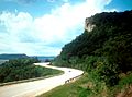
Looking north along the Great River Road in Wisconsin, with Minnesota in the distance on the west side of the Mississippi River
-
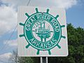
Great River Road sign in Arkansas
-
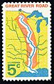
US Post Office stamp issued in 1966.
-

Illinois Route 100 14 mi (23 km) upstream of Alton


