
Honduras facts for kids
Quick facts for kids
Republic of Honduras
República de Honduras
|
|
|---|---|
 Coat of arms
|
|
|
Motto: Libre, Soberana e Independiente
"Free, Sovereign and Independent" |
|
|
Anthem: Himno Nacional de Honduras
"National Anthem of Honduras" |
|

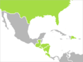
Location of Honduras
|
|
| Capital and largest city
|
Tegucigalpa 14°6′N 87°13′W / 14.100°N 87.217°W |
| Official languages | Spanish |
| Ethnic groups
(2013)
|
|
| Demonym(s) |
|
| Government | Unitary presidential republic |
| Nasry Asfura | |
|
• President of National Congress
|
Tomás Zambrano |
| Legislature | National Congress |
| Independence | |
|
• Declared from Spain
|
15 September 1821 |
|
• Declared from the
First Mexican Empire |
1 July 1823 |
|
• Declared, as Honduras, from the Federal Republic of Central America
|
5 November 1838 |
| Area | |
|
• Total
|
112,492 km2 (43,433 sq mi) (101st) |
| Population | |
|
• 2023 estimate
|
|
|
• Density
|
85/km2 (220.1/sq mi) (128th) |
| GDP (PPP) | 2025 estimate |
|
• Total
|
|
|
• Per capita
|
|
| GDP (nominal) | 2025 estimate |
|
• Total
|
|
|
• Per capita
|
|
| Gini (2018) | ▲ 52.1 high |
| HDI (2023) | medium · 139th |
| Currency | Lempira (HNL) |
| Time zone | UTC−6 (CST) |
| Date format | dd/mm/yyyy |
| Driving side | right |
| Calling code | +504 |
| ISO 3166 code | HN |
| Internet TLD | .hn |
|
|
.svg)
Honduras is a country in Central America. It used to be called Spanish Honduras to tell it apart from British Honduras, which is now Belize. Honduras shares borders with Guatemala to the west, El Salvador to the southwest, and Nicaragua to the southeast. To the south, it meets the Pacific Ocean at the Gulf of Fonseca. To the north, it has a large inlet of the Caribbean Sea called the Gulf of Honduras.
Honduras was once home to important ancient cultures, especially the Maya. In the 1500s, Spain took control of much of the country. They brought their main language, Spanish, and many of their customs. Honduras became independent in 1821 and has been a republic ever since.
The country covers about 112,492 square kilometers (43,278 square miles). It has an estimated population of over 9.5 million people. Its capital city is Tegucigalpa. The northern parts of Honduras are part of the Western Caribbean Zone.
Honduras is known for producing minerals and tropical fruits. More recently, it has become known for exporting clothing to other countries.
Contents
Honduras History: A Journey Through Time

Ancient Times: Before Europeans Arrived
Long ago, before Europeans came, modern Honduras was part of a big cultural area called Mesoamerica. In the western part of Honduras, the amazing Maya civilization thrived for hundreds of years. A very important Maya city in Honduras was Copán. This city, like other Maya centers, declined in the early 800s. Today, some Maya people, called the Ch'orti', still live in western Honduras.
Archaeologists have found remains of other ancient cultures all over the country. They have studied sites like Naco, Los Naranjos, and Yarumela. These sites show that many different groups lived in Honduras long ago.
European Arrival and Conquest
In 1502, Christopher Columbus was the first European to visit the Bay Islands off the coast of Honduras. He landed near what is now the town of Trujillo.
In 1524, the Spanish, led by Hernán Cortés, arrived in Honduras from Mexico. Most of the country was conquered over the next twenty years. Spanish soldiers, along with thousands of fighters from Mexican groups like the Tlaxcaltec and Aztecs, helped in the conquest. Some local leaders, like Lempira, bravely fought back. However, some northern regions, like the Mosquito Coast, were never fully conquered by the Spanish. After the Spanish conquest, Honduras became part of Spain's huge empire in the New World. It was part of the Captaincy General of Guatemala. The Spanish ruled the area for about 300 years.
Colonial Period: Spanish Rule
During the colonial period, Honduras was a province of the "Kingdom of Guatemala." The capital moved several times, first to Trujillo, then to Comayagua, and finally to Tegucigalpa.
Silver mining was very important to the Spanish in Honduras. At first, local people were forced to work in the mines. Later, enslaved people from other parts of Central America and then from Africa (mostly Angola) were brought in. After about 1650, fewer enslaved people arrived.
While the Spanish quickly took control of southern Honduras, they had less success in the north. They built a few towns like Puerto Caballos and Trujillo. But they could not conquer the eastern part of the region or many groups of independent indigenous people. The Miskito Kingdom in the northeast was especially good at resisting. The Miskitos even got help from European pirates and the English colony of Jamaica, which protected them after 1740.
Independence and the 1800s

Honduras gained independence from Spain in 1821. For a short time, it was part of the Mexican Empire. After 1838, Honduras became an independent republic and started holding regular elections.
Comayagua was the capital until 1880, when Tegucigalpa became the new capital.
In the 1840s and 1850s, Honduras tried several times to reunite with other Central American countries. These attempts, like the Confederation of Central America, did not last. Even though Honduras became its own republic, the idea of Central American unity remained strong. Honduras was one of the countries that pushed hardest for regional unity.
Since independence, Honduras has had nearly 300 small rebellions and civil wars. These have sometimes led to changes in government.
In the 1870s, new policies encouraged international trade and investment. Foreign companies became involved in shipping, especially tropical fruits like bananas, from the northern coast. They also helped build railways. In 1888, a planned railroad from the Caribbean coast to Tegucigalpa ran out of money when it reached San Pedro Sula. This helped San Pedro Sula grow into a major industrial center and the country's second-largest city.
International Influence in the 1900s
In the late 1800s, companies from the United States were given large areas of land and special permissions to develop the northern regions. This led to thousands of workers moving to the north coast to work on banana plantations and in other industries. Big banana companies like United Fruit Company created special "enclave economies" in northern Honduras. They controlled important infrastructure and operated almost like separate countries, contributing little to Honduras's overall economy. These companies also brought in workers from the English-speaking Caribbean, like Jamaica and Belize.
After the attack on Pearl Harbor, Honduras joined the Allied Nations on December 8, 1941. It signed the Declaration by United Nations in 1942.
In the 1950s, reforms allowed workers to form unions. This led to a general strike in 1954 that stopped work in northern Honduras for over two months. This strike helped bring about more reforms for workers.

Hurricane Fifi caused huge damage to the northern coast of Honduras in September 1974. Leaders like Melgar Castro (1975–78) and Paz Garcia (1978–82) helped build much of Honduras's modern roads and communication systems.
In 1979, the country returned to civilian rule.
In the early 1980s, the United States had a military presence in Honduras. This was to support the Contras (rebel groups) fighting the government in Nicaragua. The U.S. also built an air strip and a modern port in Honduras.

In 1998, Hurricane Mitch caused so much destruction that the former Honduran President, Carlos Roberto Flores, said it set the country back fifty years.
Honduras in the 21st Century
In 2007, Honduran President Manuel Zelaya and U.S. President George W. Bush discussed U.S. help for Honduras. This help was to fight drug cartels in eastern Honduras using U.S. special forces. This marked a new step for the U.S. military in Central America.

In 2008, under President Zelaya, Honduras joined ALBA (a political and economic alliance). But it left in 2010 after a political crisis in 2009. During this crisis, power was taken from the president and given to the head of Congress. The OAS suspended Honduras because it did not recognize the new government as legal.
Many countries, the OAS, and the United Nations officially said the action was a coup d'état and illegal. They refused to recognize the new government. However, the Honduran Supreme Court said the actions were legal. The government that followed set up a truth and reconciliation commission. After much research, this commission also concluded that the ousting was a coup and illegal.
Departments and Municipalities

Honduras is divided into 18 main areas called departments. The capital city, Tegucigalpa, is in the Central District of the Francisco Morazán department.
Here are the 18 departments:
- Atlántida
- Choluteca
- Colón
- Comayagua
- Copán
- Cortés
- El Paraíso
- Francisco Morazán
- Gracias a Dios
- Intibucá
- Islas de la Bahía
- La Paz
- Lempira
- Ocotepeque
- Olancho
- Santa Bárbara
- Valle
- Yoro
Geography and Natural Wonders

Honduras has a coast on the Caribbean Sea to the north and on the Pacific Ocean to the south, through the Gulf of Fonseca. Most of the country is located between 13° and 17° North latitude and 83° and 90° West longitude.
The climate in Honduras changes depending on the area. It is tropical in the lowlands and temperate in the mountains. The central and southern parts of the country are usually hotter and less humid than the northern coast.
Honduras is mostly covered by mountains. However, there are narrow flat areas along the coasts. In the northeast, there is a large, undeveloped jungle region called La Mosquitia. In the northwest, there is the busy Sula valley. In La Mosquitia, you'll find the Río Plátano Biosphere Reserve, which is a UNESCO world heritage site. The Coco River in this area forms part of the border with Nicaragua.
The Bay Islands and the Swan Islands (both off the north coast) are part of Honduras.

Honduras has many natural resources. These include timber, gold, silver, copper, lead, zinc, iron ore, coal, fish, shrimp, and hydropower (energy from water).
Ecology: Plants and Animals
Honduras is a place with amazing biodiversity. This means it has a huge variety of plants and animals. The country is home to over 6,000 types of vascular plants, including 630 kinds of orchids. There are also about 250 types of reptiles and amphibians, more than 700 bird species, and 110 mammal species. Half of the mammals are bats!
The Río Plátano Biosphere Reserve in the northeastern region of La Mosquitia is a lowland rainforest. It is a UNESCO World Heritage site and is full of diverse life.
Honduras has many different types of environments. These include rain forests, cloud forests (which can be very high up in the mountains), mangroves (trees that grow in salty water), savannas (grasslands with scattered trees), and mountain ranges with pine and oak trees. It is also home to part of the Mesoamerican Barrier Reef System, the second-largest coral reef system in the world. In the Bay Islands, you can see bottlenose dolphins, manta rays, parrot fish, schools of blue tang, and even whale sharks.
Economy: How Honduras Makes Money

Mines in Honduras, often owned by foreign companies, produce gold, silver, lead, and zinc.
For a long time, bananas and coffee were very important for Honduras's economy. However, their prices can change a lot, making them unreliable sources of income. In the mid-1970s, coffee exports became the leading source of money for Honduras, even more than bananas.
Demographics: The People of Honduras

Most people in Honduras, about 90%, are Mestizo. This means they have a mix of Indigenous and European family backgrounds. About 7% of the population belongs to one of the seven recognized indigenous groups.
Around 2% of Honduras's population is Black, or Afro-Honduran. Most of these people live along the country's Caribbean coast. They are mainly descendants of enslaved people and indentured servants who came from the West Indian islands. Another large group, about 150,000 people today, are the Garifuna. They are descendants of an Afro-Carib population who rebelled against the British on the island of St. Vincent and were moved to Belize and Honduras in the 1700s.

Honduras also has a notable community of people with Palestinian heritage. Most of them are Arab Christians.
Culture: Life in Honduras

One of Honduras's most famous painters is Jose Antonio Velásquez. Other important artists include Carlos Garay and Roque Zelaya. Two of Honduras's most well-known writers are Froylán Turcios and Ramón Amaya Amador. Some notable musicians include Rafael Coello Ramos and Guillermo Anderson.
Hondurans are often called Catracho (for a male) or Catracha (for a female) in Spanish.
Honduran cuisine often uses coconut in both sweet and savory dishes, and even in soups.
Celebrations and Holidays
.jpg)
Honduras celebrates several national holidays. Honduras Independence Day is on September 15. Children's Day, or Día del Niño, is celebrated on September 10. On this day, children receive gifts and have parties, similar to Christmas or birthday celebrations. Some neighborhoods even have piñatas in the street.
Other holidays include Easter, Maundy Thursday, Good Friday, and Day of the Soldier (October 3, celebrating the birth of Francisco Morazán). Christmas, El Dia de Lempira (July 20), and New Year's Eve are also important.
Independence Day festivities start early with marching bands. Each band wears different colors and has cheerleaders. On this day, there's also Fiesta Catracha, where you can enjoy traditional Honduran foods like beans, tamales, baleadas, cassava with chicharron, and tortillas. On Christmas Eve, families and friends gather for dinner and exchange presents at midnight. In some cities, fireworks light up the sky at midnight. New Year's Eve also features food, fireworks, and celebrations. Birthdays are big events too, with the famous "piñata" filled with candies and surprises for children.
La Feria Isidra is a big celebration in La Ceiba at the end of May. La Ceiba is a city on the east coast. This event is often called "The Friendship Carnival." People from all over the world come for a week of fun. Every night, there's a smaller carnival in a different neighborhood. Finally, on Saturday, there's a huge parade with floats and displays, featuring people from Brazil, New Orleans, Japan, Jamaica, Barbados, and many other countries. This celebration also includes the Milk Fair, where Hondurans show off their farm products and animals.
Transportation

Honduras has a transportation system that includes:
- 699 kilometers (434 miles) of railways.
- 13,603 kilometers (8,452 miles) of roadways.
- Seven ports and harbors.
- 112 airports in total (12 paved, 100 unpaved).
The Ministry of Public Works, Transport and Housing (SOPRTRAVI) is in charge of transportation policies in Honduras.
National Symbols

The flag of Honduras has three equal horizontal stripes. The top and bottom stripes are blue, representing the Pacific Ocean and the Caribbean Sea. The middle stripe is white. It has five blue stars, which stand for the five states of the Central American Union. The middle star represents Honduras, located in the center of this union.
The national flower is a beautiful orchid called Rhyncholaelia digbyana. It replaced the rose as the national flower in 1969. This change happened because the Rhyncholaelia digbyana is native to Honduras and has "exceptional characteristics of beauty, vigor, and distinction."
The National Tree of Honduras is the Honduras Pine (Pinus caribaea var. hondurensis). Rules were also put in place to protect this tree from being cut down or from forest fires.
The National Mammal is the White-tailed deer (Odocoileus virginianus). It was chosen to help protect it from being hunted too much. It is one of two types of deer that live in Honduras. The National Bird of Honduras is the Scarlet macaw (Ara macao). This colorful bird was highly valued by the ancient civilizations of Honduras.
Images for kids
-
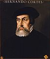
Hernán Cortés, one of the conquerors of Honduras
-
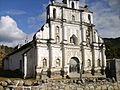
Church of San Manuel de Colohete
-
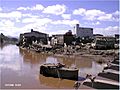
Part of the massive damage caused by Hurricane Mitch in Tegucigalpa, 1998
-
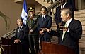
President Ricardo Maduro with U.S. Secretary of Defense Donald Rumsfeld in August 2003
-
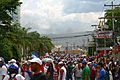
2009 Honduran coup d'état
-
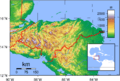
Honduras's topography.
-
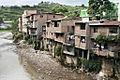
Slum in Tegucigalpa
-
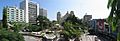
San Pedro Sula is a major center of business and commerce in Honduras, and is home to many large manufacturers and companies. It is often referred to as "La Capital Industrial".
-
CAFTA countries
-
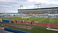
Estadio Olímpico Metropolitano in San Pedro Sula is the official ground of football in the FIFA World Cup Qualifiers.


See also
 In Spanish: Honduras para niños
