
Limburg (Belgium) facts for kids
Quick facts for kids Limburg |
|||
| Province of Belgium | |||
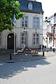
 Great Market place in Hassel.
|
|||
|
|||
| Country | |||
|---|---|---|---|
| Region | |||
| Capital | Hasselt | ||
| Highest point | Remersdaal | ||
| - location | Voeren, Tongeren, Limberg | ||
| - elevation | 287.5 m (943 ft) | ||
| - coordinates | 50°43′53.51″N 5°52′51.05″E / 50.7315306°N 5.8808472°E | ||
| Area | 2,414 km² (932 sq mi) | ||
| Population | 867,413 (1 January 2017) | ||
| Density | 359 /km² (930 /sq mi) | ||
| Subdivisions | 3 Arrondissements 44 Municipalities |
||
| Governor | Herman Reynders | ||
| Timezone | CET (UTC+1) | ||
| - summer (DST) | CEST (UTC+2) | ||
| Postal codes | 3500–3999 | ||
| ISO 3166-2 | BE-VLI | ||
.svg)
.svg)
Limburg is the easternmost of the five provinces of modern Flanders, which is one of the three main political and cultural sub-divisions of modern Belgium. Its capital is Hasselt.
Contents
Geography
Limburg is located west of the Meuse (Dutch Maas) river, upon which it borders the similarly named province Limburg of the Netherlands. It also borders on the Walloon province of Liège to the south, with which it also has historical ties. To the north and west are the old territories of the Duchy of Brabant, the Flemish provinces of Flemish Brabant and Antwerp to the west, and the Dutch province of North Brabant to the north.

The province of Limburg has an area of 2,414 km2 (932 sq mi) with a population of 867,413 and a density of 359.3 inhabitants per km². The province is divided into three arrondissements (arrondissementen in Dutch) with 44 municipalities. Among these municipalities are the current capital Hasselt, the early medieval capital Borgloon, Genk, Diepenbeek (home to Hasselt University), and Tongeren, the only Roman city in the province and regarded as the oldest city of Belgium.
The municipality of Voeren is geographically detached (an exclave) from Limburg and the rest of Flanders, with the Netherlands to the north and the Walloon province of Liège to the south. This municipality was established by the municipal reform of 1977.
The highest point of the province, 287.5 m (943.2 ft), is in the town of Remersdaal, Voeren municipality.
The centre of Belgian Limburg is crossed east to west by the Demer river and the Albert Canal, which run similar paths. The Demer river's drainage basin covers most of the central and southern part of the province, except for the southeastern corner, where the Jeker (in French: (le) Geer) runs past Tongeren and into the Maas river (in French: (la) Meuse) at Maastricht.
The eastern border of the province corresponds to the western side of the Maas, which originates in France. It's drainage basin includes not only the Jeker but most of the northern part of Belgian Limburg.
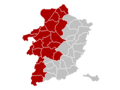
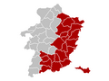
Administrative divisions
The province of Limber is divided into 3 arrondissements (Hasselt, Maaseik and Tongeren) and a total of 44 municipalities.

| Hasselt | Maaseik | Tongeren |
|---|---|---|

|

|

|
Population by arrondissement
Population on 1 January or on 1 July of each year.
| Arrondissement | 01-07-2003 | 01-07-2004 | 01-07-2005 | 01-07-2006 | 01-01-2010 | 01-01-2012 |
|---|---|---|---|---|---|---|
| Hasselt | 389,171 | 391,124 | 393,460 | 396,403 | 408,370 | 414,401 |
| Maaseik | 223,335 | 224,622 | 225,770 | 227,245 | 232,735 | 235,305 |
| Tongres | 191,386 | 191,809 | 192,732 | 193,558 | 197,400 | 199,698 |
| Province of Limbourg | 803,892 | 807,555 | 811,962 | 817,206 | 838,505 | 849,404 |
Related pages
- Limburg (Netherlands), a province in southeastern Netherlands.
Images for kids
-
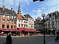
View of the Great Market place in Limburg's capital Hasselt
-
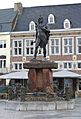
Statue of Ambiorix in the main square of Tongeren.
-
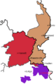
Map showing the two contemporary provinces called Limburg, (the red one in Belgium, and the brown one in the Netherlands), as well as the medieval Duchy they are both named after. Only the villages of Teuven and Remersdaal in Voeren, part of modern Belgian Limburg only since 1977, were in both modern and medieval Limburg.
-
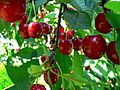
Cherries, an important product of Limburgian fruit growing business.
-
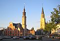
Main Market Square of Sint-Truiden with Town Hall and Church.
-
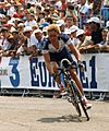
Bicycle racing
-
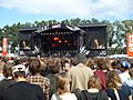
Pukkelpop music festival
-
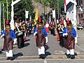
Religion and folklore: Processions
-
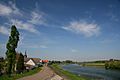
Biking road alongside Meuse river
-
The Abbey of Hocht at Lanaken
-
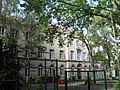
Royal Atheneum Hasselt
-
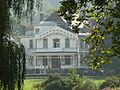
Altembrouck castle at Gravenvoeren
-

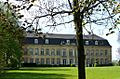
Duras castle Sint-Truiden
-
Site at Tongeren near the "Perroen"
-
Hasselt
-
Tongeren


See also
 In Spanish: Provincia de Limburgo (Bélgica) para niños
