
London Borough of Hounslow facts for kids
Quick facts for kids
London Borough of Hounslow
|
|||
|---|---|---|---|
|
|||

Hounslow shown within Greater London
|
|||
| Sovereign state | United Kingdom | ||
| Constituent country | England | ||
| Region | London | ||
| Ceremonial county | Greater London | ||
| Created | 1 April 1965 | ||
| Admin HQ | Hounslow | ||
| Government | |||
| • Type | London borough council | ||
| • Body | Hounslow London Borough Council | ||
| Area | |||
| • Total | 21.61 sq mi (55.98 km2) | ||
| Area rank | 264th (of 326) | ||
| Population
(2020)
|
|||
| • Total | 271,523 | ||
| • Rank | 56th (of 326) | ||
| • Density | 12,562.4/sq mi (4,850.4/km2) | ||
| • Ethnicity | 37.9% White British 1.9% White Irish 0.1% White Gypsy or Irish Traveller 11.5% Other White 0.9% White & Black Caribbean 0.7% White & Black African 1.3% White & Asian 1.2% Other Mixed 19% Indian 5.4% Pakistani 0.9% Bangladeshi 0.9% Chinese 8.2% Other Asian 4.2% Black African 1.3% Black Caribbean 1% Other Black 1.4% Arab 2.1% Other |
||
| Time zone | UTC (GMT) | ||
| • Summer (DST) | UTC+1 (BST) | ||
| Postcodes |
TW, W, UB, SW
|
||
| Area code(s) | 020 | ||
| ONS code | 00AT | ||
| GSS code | E09000018 | ||
| Police | Metropolitan Police | ||
| Website | http://www.hounslow.gov.uk/ | ||

The London Borough of Hounslow is a London borough in West London, England, forming part of Outer London. It was created in 1965 when three smaller Middlesex council areas amalgamated under the London Government Act 1963. It is governed by Hounslow London Borough Council.
The borough stretches from near Central London in the east (Chiswick) to the border with Surrey in the west (Feltham and Bedfont), covering five major towns: Chiswick (W4), Brentford (TW8), Isleworth (TW7), Hounslow (TW3, TW4, TW5) and Feltham (TW13, TW14); it borders the boroughs of Richmond upon Thames, Hammersmith and Fulham, Ealing and Hillingdon, in addition to the Spelthorne district of Surrey.
The Borough is home to the London Museum of Water & Steam and the attractions of Osterley Park, Gunnersbury Park, Syon House, and Chiswick House. Moreover, landmarks straddling the border of Hounslow include; Twickenham Stadium and London Heathrow Airport in the London Boroughs of Richmond-upon-Thames and Hillingdon respectively.
Contents
Districts in Hounslow
| Post Town | Other localities | ||||||
|---|---|---|---|---|---|---|---|
| Feltham | Bedfont | Hanworth | Hatton | ||||
| Brentford | Brentford Dock | ||||||
| Hounslow | Cranford | Grove Park | Lampton | Heston | North Hyde | Norwood Green (part) | |
| Isleworth | Spring Grove | Osterley | Woodlands | ||||
| South Acton (Part) | |||||||
| Chiswick | Bedford Park | Gunnersbury | Strand-on-the-Green | Turnham Green | |||

The various electoral wards of Hounslow are grouped into five Areas, each of which is given an extent of self-government:
- Chiswick
- Chiswick Homefields
- Chiswick Riverside
- Turnham Green
- Hounslow Town
- Hounslow Central
- Hounslow Heath
- Hounslow South
- Hounslow West
- Cranford
- Isleworth and Brentford
- Brentford
- Isleworth
- Osterley and Spring Grove
- Syon
- Heston
- Heston East
- Heston Central
- Heston West
- West
- Bedfont
- Feltham North
- Feltham West
- Hanworth Park
- Hanworth
Demography
53.3% of the borough's population is White, 34.4% is Asian, and 6.6% is Black. The most noticeable South Asian populations in the borough are in Hounslow, Heston and Cranford, all of which also have considerable Eastern European populations. The majority of Afro-Caribbean, West African, and East African populations are situated around the Brentford, Isleworth and Feltham areas. The majority of the White British population reside in the eastern and western parts of the borough (Chiswick, Brentford, Isleworth, Osterley, Hounslow East, Hanworth, Feltham and Bedfont), with this population being most prominent in the affluent areas of Chiswick and Osterley.
In terms of religion, 42% identify themselves as Christian, 14% Muslim, 10.3% Hindu, 9% Sikh, 1.4% Buddhist and 0.3% Jewish, 18% of the population are not religious.. At 9%, Hounslow has the largest proportion of Sikhs in London, and the third-highest in England after Slough and Wolverhampton.
The following table shows the ethnic group of respondents in the 2001 and 2011 census in Hounslow.
| Population census | ||
|---|---|---|
| Year | Pop. | ±% |
| 1801 | 11,672 | — |
| 1811 | 13,717 | +17.5% |
| 1821 | 15,861 | +15.6% |
| 1831 | 17,817 | +12.3% |
| 1841 | 20,924 | +17.4% |
| 1851 | 23,095 | +10.4% |
| 1861 | 32,942 | +42.6% |
| 1871 | 42,789 | +29.9% |
| 1881 | 52,637 | +23.0% |
| 1891 | 65,836 | +25.1% |
| 1901 | 85,688 | +30.2% |
| 1911 | 111,565 | +30.2% |
| 1921 | 132,823 | +19.1% |
| 1931 | 158,134 | +19.1% |
| 1941 | 183,060 | +15.8% |
| 1951 | 211,916 | +15.8% |
| 1961 | 209,161 | −1.3% |
| 1971 | 206,469 | −1.3% |
| 1981 | 198,967 | −3.6% |
| 1991 | 209,016 | +5.1% |
| 2001 | 212,344 | +1.6% |
| 2011 | 253,957 | +19.6% |
| Note: | ||
| Ethnic Group | 2001 | 2011 | ||
|---|---|---|---|---|
| Number | % | Number | % | |
| White: British | 118,421 | 55.77% | 96,264 | 37.91% |
| White: Irish | 6,198 | 2.92% | 4,775 | 1.88% |
| White: Gypsy or Irish Traveller | 183 | 0.07% | ||
| White: Other | 13,135 | 6.19% | 29,283 | 11.53% |
| White: Total | 137,754 | 64.87% | 130,505 | 51.39% |
| Asian or Asian British: Indian | 36,812 | 17.34% | 48,161 | 18.96% |
| Asian or Asian British: Pakistani | 9,127 | 4.30% | 13,676 | 5.39% |
| Asian or Asian British: Bangladeshi | 1,125 | 0.53% | 2,189 | 0.86% |
| Asian or Asian British: Chinese | 1,842 | 0.87% | 2,405 | 0.95% |
| Asian or Asian British: Other Asian | 5,446 | 2.56% | 20,826 | 8.20% |
| Asian or Asian British: Total | 54,352 | 25.60% | 87,257 | 34.36% |
| Black or Black British: African | 5,723 | 2.70% | 10,787 | 4.25% |
| Black or Black British: Caribbean | 2,826 | 1.33% | 3,381 | 1.33% |
| Black or Black British: Other Black | 688 | 0.32% | 2,645 | 1.04% |
| Black or Black British: Total | 9,237 | 4.35% | 16,813 | 6.62% |
| Mixed: White and Black Caribbean | 1,382 | 0.65% | 2,273 | 0.90% |
| Mixed: White and Black African | 843 | 0.40% | 1,730 | 0.68% |
| Mixed: White and Asian | 2,407 | 1.13% | 3,390 | 1.33% |
| Mixed: Other Mixed | 1,815 | 0.85% | 2,956 | 1.16% |
| Mixed: Total | 6,447 | 3.04% | 10,349 | 4.08% |
| Other: Arab | 3,638 | 1.43% | ||
| Other: Any other ethnic group | 5,395 | 2.12% | ||
| Other: Total | 4,551 | 2.14% | 9,033 | 3.56% |
| Black, Asian, and minority ethnic: Total | 74,587 | 35.13% | 123,452 | 48.61% |
| Total | 212,341 | 100.00% | 253,957 | 100.00% |
Political composition

Elections across the London Boroughs are currently held every four years. Since the Hounslow borough was formed it has been controlled by the Labour Party on all but two elections: in 1968 the Conservatives formed a majority until they lost control to Labour in 1971. The 2006 local elections produced a no overall control result. Although Labour was the largest party on the Council, the Conservatives formed a coalition with the six Councillors from the independent Isleworth Community Group (ICG) which administered the area until the 2010 local elections when Labour regained control.
Seat distribution as of 2014 elections:
style="width: 2px; background-color: #E4003B;" data-sort-value="Labour Party (UK)" | style="width: 2px; background-color: #0087DC;" data-sort-value="Conservative Party (UK)" |
| Party | Seats | |
|---|---|---|
| Labour | 49 | |
| Conservative | 11 | |
| Total | 60 | |
Reflecting how votes were cast in the national elections, in separate polls held the same day, for the 2010-2014 period, the Conservatives and Labour won fifteen seats each from the Brentford and Isleworth (UK Parliament constituency). Overall, control was held by the Council's Labour administration as 20 Labour Party Councillors and 10 Conservative Party Councillors were elected for wards in the Feltham and Heston half of the borough.
Between 1998 and 2006 Independents were elected to the London Borough of Hounslow from the area. The first Independent Community Group (ICG) Councillor was elected in 1998 as Isleworth Community Group in Isleworth. In 2002 three ICG Councillors were elected in Isleworth. In 2006 six ICG Councillors were elected (Syon and Isleworth wards), and former Labour Leader of the Council John Connelly was re-elected as an Independent in Hounslow Heath ward. All seven of the Independents were defeated in the local elections held on 6 May 2010 by, in their respective wards, Labour Party candidates. Since then one Conservative councillor has become an Independent and four Conservative Councillors have defected to UKIP.
History
See
for the history of each


Etymology
The town of Hounslow, which has existed since the 13th Century, is located at the centre of the Borough of Hounslow. The name Hounslow means 'Hund's mound'; the personal name Hund is followed by the Old English hlaew meaning mound or barrow. (The mound may have been his burial place.) It was recorded in the Domesday Book as Honeslaw.
Foundations
The borough was formed in 1965, under the London Government Act 1963, by the merger of the area of the former Brentford and Chiswick Urban District, Feltham Urban District and the Heston and Isleworth Urban District (which held borough status as did Brentford and Chiswick) of Middlesex.
This outer borough of Greater London lies on the Middlesex bank of the River Thames and was the site of the first stop on an important coach route to Southampton, Bath, Bristol and Exeter. The A30 "Great South West Road" trunk road, which runs down to Penzance in Cornwall, starts in the borough. Hounslow town developed on either side of the main Great West Road from London to the West of England (not to be confused with the modern road of the same name), causing a large number of inns to be built to serve the travellers. A few, such as The Bell retain their names, although the buildings have largely been replaced. The Bell marks the former junction of the coaching routes. Historic milestones are preserved on the Staines Road (now re-numbered as the A315 but joining the "old" A30 again just inside the borough's western boundary)
Hounslow grew rapidly in the latter half of the 20th century due to other travel, a connection to the largest of London's airports since the 1940s, Heathrow Airport which is in the Hounslow post town. Little known is that aviation dates to the early 1900s here when one of London's earliest airfields was situated on Hounslow Heath because of the extremely flat terrain. The Great West Road, which crosses the borough from Chiswick to Heathrow, at one time served nationally and globally famous manufacturers including Firestone, Gillette and Coty. As a result, the area became known as the "Golden Mile". A few of these factory sites remain today, such as Gillette Corner, and the Great West Road is still home to many prestigious names (see "famous companies" below), providing them with easy non-motorway access between Slough, London Heathrow Airport and Central London.
Transport
Air
Hounslow abuts the perimeter of London Heathrow Airport in the London Borough of Hillingdon. Plans for the expansion of Heathrow Airport are vigorously opposed by Hounslow if such plans increase or widen noise and pollution, weighed against arguments of greater employment and spending.
Bus
The borough has forty-seven bus routes (27, 65, 81, 90, 94, 105, 110, 111, 116, 117, 120, 190, 195, 203, 222, 235, 237, 267, 272, 281, 285, 290, 391, 423, 440, 481, 482, 490, 635, 681, 813, 941, E2, E3, E6, E8, H20, H22, H25, H26, H28, H32, H37, H91, H98, R70, X26), some of which are 24 hours services, and two night services (N9 and N11).
Rail
The borough's railway stations are:
- on the North London Line: Gunnersbury.
- on the Hounslow Loop Line: Chiswick, Kew Bridge, Brentford, Isleworth, Syon Lane, and Hounslow.
- on the mainline: Feltham.
River
River services between Westminster Pier and Hampton Court depart from Kew Gardens Pier just across the River Thames from Hounslow.
Road
Principal roads in Hounslow include the A4 (Great West Road), the elevated section of the M4 motorway, the A406 (North Circular) and A205 (South Circular) roads, all of which meet at Gunnersbury just west of Chiswick. The A4 runs eastwards into central London via the Hogarth Roundabout where it meets the A316 (Great Chertsey Road) which runs south-west, eventually joining the M3 motorway.
Underground
The borough is served by branches of two London Underground lines District line:
- Stamford Brook: District line, Richmond and Ealing Broadway branches;
- Turnham Green: District line, Richmond and Ealing Broadway branches and Piccadilly line (early mornings and late evenings only);
- Gunnersbury: District line, Richmond branch
- Boston Manor: Heathrow branch (as all stations below);
- Osterley
- Hounslow East
- Hounslow Central
- Hounslow West
Three stations lie just outside the borough's northern boundaries. Chiswick Park and Acton Town (both in the London Borough of Ealing) and Hatton Cross tube station (in the London Borough of Hillingdon) serve the borough's residents.
Travel to work
In March 2011, the main forms of transport that residents used to travel to work were (of all residents aged 16–74):
- driving a car or van, 26.7%;
- bus, minibus or coach, 10.5%;
- underground, metro, light rail, tram, 10.5%;
- train, 5.5%;
- on foot, 5.0%;
- work mainly at or from home, 2.9%;
- bicycle, 2.2%.
Sport and leisure
The borough of Hounslow has several Non-League football clubs:
- CB Hounslow United F.C. who play at the Osterley Sports Ground.
- Hanworth Villa F.C. who play at Rectory Meadow.
- Bedfont & Feltham F.C. who currently play at the Orchard in East Bedfont.
- Bedfont Sports F.C. who play at the Bedfont Sports Recreation Ground.
- Ashford Town F.C. (Middlesex) who play at The Robert Parker Stadium.
The borough is also home to Staines Rugby Football Club who play at the "Reeves" in Hanworth.
Twinning
Hounslow has a sister district agreement with Leningradsky District in Krasnodar Krai, Russia.
Economy
The borough is home to the headquarters of GlaxoSmithKline and Sky plc, both based in Brentford's 'Golden Mile' stretch of the A4 Great West Road, and several supermarket outlets once known across the globe for its cluster of factories and offices, and is currently going under extensive re developments in the form of new apartment blocks and offices. Fuller's Griffin Brewery is also in the borough, in Chiswick. Aston Martin were based in Feltham for several years before moving to Newport Pagnell, Buckinghamshire.
DHL Air UK has its head office in Hounslow.
Air France-KLM's head office for United Kingdom and Ireland operations, which includes facilities for Air France and KLM, is located in Plesman House in Hatton Cross in the borough. The Plesman House, outside of Terminal 4 of London Heathrow Airport, has the UK commercial team, sales team, and support team. Sega Europe has its head office in Brentford. Menzies Aviation has its head office by the airport in Feltham. JCDecaux UK has its head office in Brentford.
Before winding-up British Mediterranean Airways was headquartered at Hetherington House near London Heathrow Airport
A 2017 study by Trust for London and New Policy Institute found that pay inequality in Hounslow is the second largest of any London borough. It also found that 25% people in Hounslow live in poverty, which is slightly lower than the London-wide poverty rate of 27%.
Education
Images for kids
-
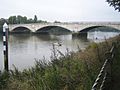
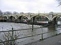
River Thames at Chiswick overlooking Chiswick Bridge
-
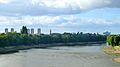
The Thames looking towards Brentford, Chiswick and Hammersmith, with the Brentford Towers on the left.
-
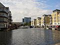
Brentford Lock development with GlaxoSmithKline building in the background
-
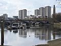
View from Chiswick, from right to left; Brentford Museum of Water and Steam pumping tower, Kew Bridge (Centre), River Thames, Brentford Towers, GSK building
-
Richmond Lock view from Isleworth
-
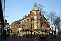
West End of Hounslow High Street
-
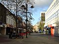
Central section of Hounslow High Street
-
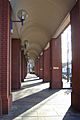
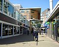
Back of Treaty Centre, Hounslow
-
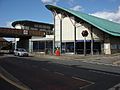
Hounslow East
-
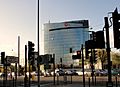
GSK building at Brentford
-
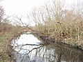
River Crane at Hounslow Heath, Separating Feltham and Hounslow
-
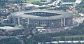
View from Isleworth of Twickenham Stadium
-
The Centre, Feltham
-
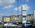
New Developments at The Centre, Feltham
-
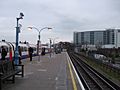
View of the Blenhiem Centre from Hounslow Central Station


See also
 In Spanish: Municipio de Hounslow para niños
