
Santa Marta facts for kids
Quick facts for kids
Santa Marta
|
|||
|---|---|---|---|
|
Municipality and city
|
|||

Top: Panorama of the Cienaga Grande de Santa Marta, 2nd left: Mirador in Cabo San Juan del Guia, Tayrona Natural Park, 2nd right: Santa Marta Cathedral, 3rd left: Statue of Simon Bolívar in Quinta of Saint Pedro Alejandrino, 3rd upper middle: Colombian National Pantheon in Barrio Mamatoco, 3rd lower middle: Santa Marta City Hall, 3rd right: Tribute to the Tayrona Ethnicity Square, Bottom: Panorama of Acuático El Rodadero Park
|
|||
|
|||
| Nickname(s):
America's Pearl (La Perla de America)
|
|||

Location in the Department of Magdalena.
Municipality (red) City (dark grey) |
|||

Santa Marta
Location in Colombia
|
|||
| Country | |||
| Region | Caribbean Region | ||
| Department | Magdalena | ||
| Foundation | July 29, 1525 | ||
| Founded by | Rodrigo de Bastidas | ||
| Named for | Martha | ||
| Area | |||
| • Municipality and city | 2,393.65 km2 (924.07 sq mi) | ||
| • Urban | 55.10 km2 (21.27 sq mi) | ||
| Elevation | 15 m (49 ft) | ||
| Population
(2018 Census)
|
|||
| • Municipality and city | 499,192 | ||
| • Density | 208.5485/km2 (540.210/sq mi) | ||
| • Urban | 455,299 | ||
| • Urban density | 8,263.1/km2 (21,406/sq mi) | ||
| DANE | |||
| Demonym(s) | Samario | ||
| Time zone | UTC-05:00 (Colombia Time) | ||
| Postal codes |
470001–470017
|
||
| Area code(s) | 57 + 5 | ||
| Website | Official website: http://www.santamarta-magdalena.gov.co | ||

.svg)
Santa Marta (Spanish pronunciation: [ˌsanta ˈmaɾta]), officially the Distrito Turístico, Cultural e Histórico de Santa Marta (English: Touristic, Cultural and Historic District of Santa Marta), is a city on the coast of the Caribbean Sea in northern Colombia. It is the capital of Magdalena Department and the fourth-largest urban city of the Caribbean Region of Colombia, after Barranquilla, Cartagena, and Soledad. Founded on July 29, 1525, by the Spanish conqueror Rodrigo de Bastidas, it was one of the first Spanish settlements in Colombia, its oldest surviving city, and second oldest in South America. This city is situated on a bay by the same name and as such, it is a prime tourist destination in the Caribbean region.
Contents
History
Pre-Colombian times
Before the arrival of Europeans, the South American continent was inhabited by a number of indigenous groups. Due to a combination of tropical weather, significant rainfall, and the destruction and misrepresentation of many records by Spanish conquistadors, our understanding of the peoples of this region is limited.
The Tairona formed mid- to large-size population centers, consisting of stone pathways, terraces, protected waterways, and spaces dedicated to agricultural produce. Their economy was primarily agricultural, cultivating corn, pineapple, yucca, and other local foodstuffs. The Tayrona are considered quite advanced for their time period. Surviving archaeological sites consisted of formed terraces and small scale underground stone channels. They were known to actively collect and process salt, which was a significant trading commodity.
They traded with other indigenous groups along the coast and interior. Archaeological excavations have recovered significant works in pottery, stonework and gold.
Flag
Santa Marta's flag consists of two colors: white and blue. White symbolises peace, in that all are united without restriction. Blue symbolises the sky, the sea, the magic found in the horizon, and the snow-capped Sierra Nevada mountains.
Geography

Santa Marta is located on Santa Marta Bay of the Caribbean Sea in the province of Magdalena. It is 992 km from Bogotá and 93 km from Barranquilla. It is bordered to the north and west by the Caribbean and to the south by the municipalities of Aracataca and Ciénaga.
Climate
Santa Marta experiences a hot semi-arid climate (Köppen BSh) with largely uniform temperatures year round. The dry season lasts from December to April, while the wet season lasts from May to November.
| Climate data for Santa Marta (Simón Bolívar International Airport) 1981-2010 | |||||||||||||
|---|---|---|---|---|---|---|---|---|---|---|---|---|---|
| Month | Jan | Feb | Mar | Apr | May | Jun | Jul | Aug | Sep | Oct | Nov | Dec | Year |
| Record high °C (°F) | 37.0 (98.6) |
38.2 (100.8) |
37.0 (98.6) |
37.6 (99.7) |
37.4 (99.3) |
37.4 (99.3) |
37.8 (100.0) |
37.4 (99.3) |
37.2 (99.0) |
36.2 (97.2) |
38.2 (100.8) |
37.6 (99.7) |
38.2 (100.8) |
| Average high °C (°F) | 33.0 (91.4) |
33.6 (92.5) |
33.8 (92.8) |
33.6 (92.5) |
32.9 (91.2) |
33.0 (91.4) |
33.0 (91.4) |
32.8 (91.0) |
32.5 (90.5) |
32.1 (89.8) |
32.1 (89.8) |
32.4 (90.3) |
32.9 (91.2) |
| Daily mean °C (°F) | 27.4 (81.3) |
27.9 (82.2) |
28.4 (83.1) |
28.9 (84.0) |
29.1 (84.4) |
29.1 (84.4) |
28.8 (83.8) |
28.6 (83.5) |
28.3 (82.9) |
27.9 (82.2) |
27.8 (82.0) |
27.5 (81.5) |
28.3 (82.9) |
| Average low °C (°F) | 22.3 (72.1) |
23.2 (73.8) |
24.2 (75.6) |
25.3 (77.5) |
25.5 (77.9) |
25.1 (77.2) |
24.6 (76.3) |
24.5 (76.1) |
24.3 (75.7) |
24.2 (75.6) |
23.8 (74.8) |
22.7 (72.9) |
24.1 (75.4) |
| Record low °C (°F) | 17.4 (63.3) |
18.3 (64.9) |
20.0 (68.0) |
19.0 (66.2) |
18.0 (64.4) |
19.0 (66.2) |
18.0 (64.4) |
18.0 (64.4) |
17.0 (62.6) |
17.0 (62.6) |
17.0 (62.6) |
18.0 (64.4) |
17.0 (62.6) |
| Average rainfall mm (inches) | 3.1 (0.12) |
2.0 (0.08) |
2.3 (0.09) |
14.1 (0.56) |
55.4 (2.18) |
60.7 (2.39) |
59.6 (2.35) |
70.0 (2.76) |
88.3 (3.48) |
111.0 (4.37) |
63.5 (2.50) |
15.2 (0.60) |
545.3 (21.47) |
| Average rainy days | 0 | 1 | 1 | 3 | 7 | 9 | 10 | 13 | 13 | 13 | 8 | 2 | 80 |
| Average relative humidity (%) | 74 | 72 | 72 | 74 | 76 | 76 | 77 | 78 | 79 | 80 | 79 | 76 | 76 |
| Mean monthly sunshine hours | 285.2 | 248.6 | 251.1 | 228.0 | 223.2 | 228.0 | 232.5 | 220.1 | 201.0 | 204.6 | 219.0 | 269.7 | 2,811 |
| Mean daily sunshine hours | 9.2 | 8.8 | 8.1 | 7.6 | 7.2 | 7.6 | 7.5 | 7.1 | 6.7 | 6.6 | 7.3 | 8.7 | 7.7 |
| Source: Instituto de Hidrologia Meteorologia y Estudios Ambientales | |||||||||||||
Economy
Santa Marta's economy is based on tourism, trade, port activities, fishing and agriculture, in that order. The main agricultural products are: bananas, coffee, cocoa and cassava.
Infrastructure
Santa Marta is a major port. Simón Bolívar International Airport (IATA: SMR ) is 16 km (10 mi) from the city centre. Historic figure Simón Bolívar died here, a significant event for South America as a whole. His villa known as La Quinta de San Pedro Alejandrino is located just outside the city centre. As the main city centre is located close to the coast, the city itself has had difficulty controlling expansion. Although, technically a separate locality, Rodadero is part of Santa Marta itself.
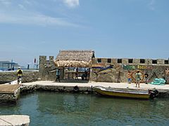
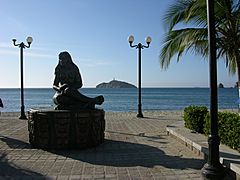
Gallery
-
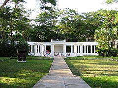
Quinta de San Pedro Alejandrino in Santa Marta
-
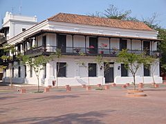
Casa de la Aduana y Alcapulca
-
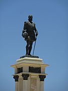
Statue of Rodrigo de Bastidas


_-_Estatua_de_Rodrigo_de_Bastidas.jpg)
-
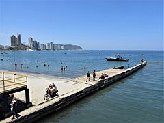
Rodadero, Santa Marta
-
Rodadero aquarium
-
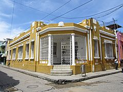
Traditional house in Santa Marta
_-_Playa_principal_desde_el_Canal_de_Las_Iguanas_-_Colombia.jpg)

_-_Casa_amarilla_en_la_esquina_de_la_calle_18_con_carrera_4.jpg)
-
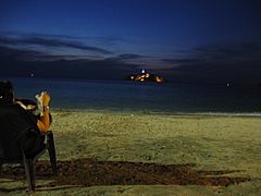
Lighthouse in the bay of Santa Marta
-
El Morro island off the coast of Santa Marta
-
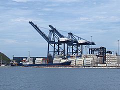
Harbour of Santa Marta


-
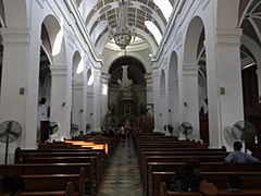
The cathedral (inner view)
-
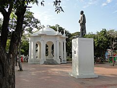
On central square
-
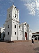
The cathedral
.jpg)

.jpg)
Notable people
- Carlos Vives, singer of vallenato music
- Radamel Falcao, professional footballer
- Taliana Vargas, actress and model
- Alejandro Palacio, singer of vallenato music
- Sergio Díaz-Granados Guida, IDB Executive Director for Colombia and Peru
- Maria Claudia Lacouture, executive director of the Colombo American Chamber of Commerce
- Carlos Valderrama, professional footballer
- Andrés Solano, professional footballer
- Johan Vonlanthen, professional footballer
- Arturo Reyes, football coach
- Inés María Zabaraín, journalist
- Luis Javier Suárez, professional footballer
See also
 In Spanish: Santa Marta (Colombia) para niños
