
Santa Marta facts for kids
Quick facts for kids
Santa Marta
|
|||
|---|---|---|---|
|
District and city
|
|||

Top: Panorama of the Cienaga Grande de Santa Marta, 2nd left: Mirador in Cabo San Juan del Guia, Tayrona Natural Park, 2nd right: Santa Marta Cathedral, 3rd left: Statue of Simon Bolívar in Quinta of Saint Pedro Alejandrino, 3rd upper middle: Colombian National Pantheon in Barrio Mamatoco, 3rd lower middle: Santa Marta City Hall, 3rd right: Tribute to the Tayrona Ethnicity Square, Bottom: Panorama of Acuático El Rodadero Park
|
|||
|
|||
| Nickname(s):
America's Pearl (La Perla de America)
|
|||

Location in the Department of Magdalena.
Municipality (red) City (dark grey) |
|||

Santa Marta
Location in Colombia
|
|||
| Country | |||
| Region | Caribbean Region | ||
| Department | Magdalena | ||
| Foundation | July 29, 1525 | ||
| Founded by | Rodrigo de Bastidas | ||
| Named for | Martha | ||
| Area | |||
| • District and city | 2,393.65 km2 (924.07 sq mi) | ||
| • Urban | 55.10 km2 (21.27 sq mi) | ||
| Elevation | 15 m (49 ft) | ||
| Population
(2018 Census)
|
|||
| • District and city | 499,192 | ||
| • Density | 208.5485/km2 (540.210/sq mi) | ||
| • Urban | 455,299 | ||
| • Urban density | 8,263.1/km2 (21,406/sq mi) | ||
| DANE | |||
| Demonym(s) | Samario | ||
| Time zone | UTC-05:00 (Colombia Time) | ||
| Postal codes |
470001–470017
|
||
| Area code(s) | 57 + 5 | ||
| Website | Official website: http://www.santamarta-magdalena.gov.co | ||

.svg)
Santa Marta is a lively port city located on the coast of the Caribbean Sea in northern Colombia. It is also known as the Historic, Cultural & Tourist District of Santa Marta. This city is the capital of the Magdalena Department. It is the fourth-largest city in Colombia's Caribbean Region.
Santa Marta was founded on July 29, 1525, by the Spanish explorer Rodrigo de Bastidas. It was one of the very first Spanish settlements in Colombia. It is also the oldest city that is still standing in Colombia. In fact, it is the second oldest city in all of South America. The city sits on a beautiful bay, making it a popular spot for tourists in the Caribbean.
Contents
History of Santa Marta
Ancient Times: Before Europeans Arrived
Before Europeans came, many native groups lived in South America. We do not know everything about these groups. This is because of the tropical weather and heavy rain. Also, many records were lost or changed by the Spanish conquerors.
One important group was the Tairona people. They built medium to large towns. These towns had stone paths, terraces, and protected water systems. They also had special areas for growing food. The Tairona people were very advanced for their time. They grew crops like corn, pineapple, and yucca.
Archaeologists have found old Tairona sites. These sites show well-made terraces and small underground stone channels. The Tairona were also known for collecting and processing salt. Salt was a very important item for trading with other native groups. They traded with groups along the coast and inland. Many beautiful items made of pottery, stone, and gold have been found from their time.
The Flag of Santa Marta
The flag of Santa Marta has two main colors: white and blue. The white color stands for peace. It shows that everyone in Santa Marta is united. The blue color represents the sky and the sea. It also symbolizes the magic of the horizon. And it reminds people of the snow-capped Sierra Nevada de Santa Marta mountains nearby.
Where Santa Marta Is Located

Santa Marta is located on Santa Marta Bay. This bay is part of the Caribbean Sea. The city is in the Magdalena province of Colombia. It is about 992 kilometers (616 miles) from Bogotá, the capital of Colombia. It is also 93 kilometers (58 miles) from Barranquilla. To the north and west, Santa Marta is bordered by the Caribbean Sea. To the south, it borders the towns of Aracataca and Ciénaga.
Santa Marta's Climate
Santa Marta has a tropical savanna climate. This means it has warm temperatures all year round. It also has a dry season and a wet season. The dry season runs from December to April. The wet season lasts from May to November.
Santa Marta's Economy
The economy of Santa Marta depends on a few main things. These are tourism, trade, and port activities. Fishing and agriculture are also important. The main crops grown in the area are bananas, coffee, cocoa, and cassava.
City Infrastructure
Santa Marta is a very important port city. The Simón Bolívar International Airport is about 16 kilometers (10 miles) from the city center. A famous historical figure, Simón Bolívar, died here. This was a very important event for all of South America. His old home, called La Quinta de San Pedro Alejandrino, is just outside the city center. The city center is very close to the coast. This has made it a bit tricky to control how much the city grows. Rodadero is a popular tourist area that is part of Santa Marta.
Images for kids
-
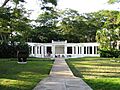
Quinta de San Pedro Alejandrino in Santa Marta
-
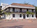
Casa de la Aduana
-
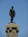
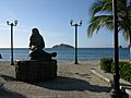
Statue of Rodrigo de Bastidas
-
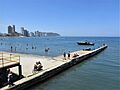
Rodadero, Santa Marta
-
Rodadero aquarium
-
Traditional house in Santa Marta
-
Lighthouse in the bay of Santa Marta
-
El Morro island off the coast of Santa Marta
-
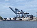
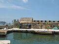
Harbour of Santa Marta
-
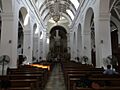
The cathedral (inner view)
-
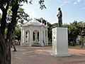
On central square
-
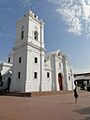
The cathedral


_-_Estatua_de_Rodrigo_de_Bastidas.jpg)
_-_Playa_principal_desde_el_Canal_de_Las_Iguanas_-_Colombia.jpg)

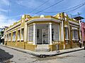
_-_Casa_amarilla_en_la_esquina_de_la_calle_18_con_carrera_4.jpg)


.jpg)

.jpg)
Famous People from Santa Marta
Many talented people come from Santa Marta, including:
- Radamel Falcao, a professional football (soccer) player
- Jesús Ferreira, a professional football (soccer) player
- Alejandro Palacio, a singer of vallenato music
- Aldo Leão Ramírez, a professional football (soccer) player
- Li Saumet, the lead singer of the band Bomba Estéreo
- Luis Javier Suárez, a professional football (soccer) player
- Carlos Valderrama, a famous professional football (soccer) player
- Taliana Vargas, an actress and model
- Carlos Vives, a well-known singer of vallenato music
- Lalo Ebratt, a Reggaeton singer
Santa Marta in Media
Santa Marta was used as the filming location for the TV series The White Slave.
See also
 In Spanish: Santa Marta (Colombia) para niños
